Follow along as participants in the cruise provide updates and reflections on their experiences, the science, the technology, and other elements of the expedition.
August 6, 2010 | By Tom Kok

They say a journey of a thousand miles begins with a single step. For Tom Kok, a journey of several thousand miles began with a single phone call. That call came from Dave Lovalvo, the Remotely Operated Vehicle (ROV) Operations Manager on NOAA Ship Okeanos Explorer. When Dave asked Tom if he was interested in traveling to the Okeanos Explorer to work with the ROV team, he had no practical experience with ships, no practical experience with ROVs, and absolutely no idea what to expect. As a recent mechanical engineer graduate, he was about to embark on an exciting and challenging voyage known as ocean exploration.
Read moreAugust 5, 2010 | By Colleen Peters

People are easily mesmerized by biology. It moves! It wiggles! It spits! This makes the remotely operated vehicle (ROV) video particularly captivating for a wide audience. In comparison, mapping is perhaps ‘not as entertaining.’ I have to admit, standing a mapping watch through the midnight hours (one of my main duties) is not the most exhilarating activity, but is a key and necessary component of our mission.
Read moreAugust 4, 2010 | By Wahyu W.Pandoe

Baruna Jaya IV’s recent multibeam survey to the west of Siau revealed a previously unknown seamount rising from seafloor depths of 2,300 meters to 710 meters, or nearly 1,600 meters high. This seamount is located about 8 kilometers to the west of Siau Island. Baruna Jaya IV is further investigating the site by collecting CTD measurements and trawling/dredging to learn more.
Read moreAugust 3, 2010 | By Jeremy Potter

Someone pulled out a thread on the fabric of time and space. At least that’s how it feels to be associated with this expedition. While NOAA Ship Okeanos Explorer is operating in Indonesian waters, satellite and high-speed Internet pathways, AKA “telepresence,” enables shore-side scientist participation across the globe.
Read moreAugust 2, 2010 | By ENS Matt O'Leary


Meet Ensign Matt O’Leary, an officer in the NOAA Commissioned Officer Corps, currently assigned to NOAA Ship Okeanos Explorer. The NOAA Corps, comprised of just over 300 officers, is the smallest of our nation’s seven uniformed services. The Corps can trace its history back to the founding of the Survey of the Coast in 1807, but they didn’t become a uniformed service until 1917. NOAA Corps officers work throughout all of NOAA’s offices, both onshore and at sea aboard NOAA’s fleet of 19 vessels (and 12 aircraft).
Read moreAugust 1, 2010 | By Molly Timmers

While NOAA Ship Okeanos Explorer continues to map and examine the undersea environment with a focus on the deeper waters of the Sangihe Talaud region, the Indonesian Research Vessel Baruna Jaya IV continues to conduct complementary operations: mapping shallower areas of the seafloor and assessing marine habitats using a variety of technologies. Read on to learn more about some of the work being conducted from Baruna Jaya IV as part of the INDEX-SATAL 2010 expedition.
Read moreJuly 31, 2010 | By Meme Lobecker and Elaine Stuart

The EM302 multibeam sonar system onboard NOAA Ship Okeanos Explorer is one of the most state-of-the-art systems of its kind available in the world today. Manufactured by Kongsberg in Horten, Norway, the EM302 is capable of detecting features on the seafloor at relative sizes much smaller than have historically been detectable by similar sonars.
Read moreJuly 29, 2010 | By Colleen Peters

The mapping, Conductivity Temperature Depth sampling, and remotely operated vehicle (ROV) dives would not be possible without the ship’s crew to maintain the platform from which we explore the ocean. Here is a brief look at what a typical day is like on NOAA ship Okeanos Explorer while the ship is underway and conducting operations. Not everyone is directly involved in the mission activities on a daily basis, but everyone on the ship has a very important role in the success of the mission.
Read moreJuly 27, 2010 | By Colleen Peters

Going to sea can be a lot like band camp (and I should know—I went four times!). It generally takes place during the summer (field season). You pack up your instruments (scientific equipment) and personal effects, move to a remote location such as a campground (ship) upstate (offshore) where you won’t be distracted by the outside world (newspapers and TV) and where everyone works together to focus on the new show (mission).
Read moreJuly 26, 2010 | By Jeremy Potter

“Creative solutions turn challenges into opportunities.” U.S. Ambassador to Indonesia Cameron Hume wrote those words in an op-ed a few years ago. He also lives by them. The INDEX-SATAL 2010 expedition was one of those rare opportunities that he envisioned. It seems quite appropriate that one of his biggest successes is bearing fruit in the waning time of his tour as U.S. Ambassador to Indonesia.
Read moreJuly 24, 2010 | By Randy Visser

Video technology plays a big role in the exploration we are engaged with here on NOAA Ship Okeanos Explorer. The ship is outfitted with a variety of cameras and other cameras are mounted on both the camera platform and the remotely operated vehicle (ROV) itself. The ROV pilots use these cameras as their eyes while diving. Other members of the team, including the scientists, use the images created by these cameras to identify various marine species and environments, helping to guide the pilots and direct the exploration during a dive. And of course, people gathered at the various Exploration Command Centers around the globe use the images to participate in this experience in real time.
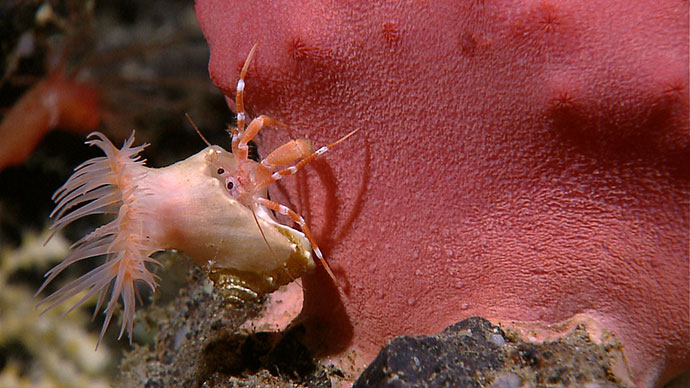
Read moreJuly 22, 2010 | By Dave Lovalvo
, streamed live to the ship and shore-side Exploration Command Centers, are viewed by scientists with the expertise to identify seafloor life and habitats.")
As we continue on our first mission of ocean exploration, collectively we must strive to answer what still today remains one of our most controversial questions: Where does exploration stop and research science begin? Serious thought should be given as to how we stay true to the mission that defines us.
Read moreJuly 12, 2010 | By Eleanor Bors

As doctoral student Eleanor Bors sits in Seattle, Washington, in the technologically equipped "Exploration Command Center", she can’t help but marvel at viewing live deep-sea creatures half a world away, and thousands of feet deep, in real time.
Read moreJuly 11, 2010 | By Santiago Herrera
 lack any form of fused internal skeleton.")

Today we had one of the most interesting dives so far during this expedition. The location was the volcanic feature termed “Target K” in the southwestern part of our area of operations. The summit of this seamount reaches a depth of approximately 460 meters below sea level.
Read moreJuly 9, 2010 | By Webb Pinner and Kelley Elliott

Implementing “telepresence,” or the real-time participation of geographically distributed participants, in a single event is far from simple. A variety of tools and technologies are being utilized aboard the Okeanos Explorer to facilitate this remote participation during the INDEX-SATAL 2010 expedition.
Read moreJuly 7, 2010 | By Dave Lovalvo


Many people are curious as to the cast of characters that make an operation like this work. Cast in this case, is a very appropriate term. There is no single individual, no star of the show. It’s teamwork, with numerous players, many of which are behind the scenes both on the ship and on the shore.
Read moreJuly 5, 2010 | By David McKinnie

While NOAA Ship Okeanos Explorer has been offshore doing preliminary work mapping the deeper waters of the INDEX 2010 operating area, the Indonesian Research Vessel Baruna Jaya IV has been busy making final preparations to join the expedition and bring her complementary capabilities to bear on exploring the Sangihe-Talaud region.
Read moreJuly 4, 2010 | By Colleen Peters

Ocean exploration may be about 25 percent exhilaration and 75 percent perspiration. It is incredibly exciting to be on the cutting edges of technology and getting to look at areas of the world’s ocean that have never been observed before. However, what most people may not realize is how many days at sea it really takes to get those few good images, that one great map, and the dive that will change the course of history.
Read moreJuly 2, 2010 | By David McKinnie
 and David McKinnie (left), NOAA liaison to the US Embassy-Jakarta watch video from the <em>Okeanos Explorer</em> INDEX 2010 Expedition during the US Embassy-Jakarta 4th of July Celebration.")
At American Embassies around the world, one of the most important events of the year is the 4th of July celebration. Indonesia is large enough to merit three of them – in Surabaya, Jakarta, and Medan – on different days. This year, Jakarta celebrated the 4th on July 2nd. The celebration was special for NOAA and its ocean exploration partners in Indonesia.
Read moreJune 30, 2010 | By Verena Tunnicliffe


We are deep in one of the most exotic seas in the world – the centre of the Coral Triangle with the highest diversity of marine animals in the world. The Little Hercules remotely operated vehicle is throwing a tiny spotlight onto deep-sea habitats rarely seen before our exploration. As we neared the first hydrothermal venting on the summit of Kawio Barat, the biologists were excited to discover what types of animals would inhabit the vents.
Read moreJune 29, 2010 | By Kelley Elliott and David Butterfield

After many months of planning and preparation, today marked the first day of full telepresence operations at the Exploration Command Center (ECC) based in Seattle, Washington. Scientists and other participants began arriving at 1700 local time to an office space at the NOAA Pacific Marine Environmental Laboratory, set-up with six large, high-definition monitors; several computers; and an RTS Intercom Unit enabling real-time communication with NOAA Ship Okeanos Explorer and other shore-side ECCs.
Read moreJune 27, 2010 | By James Holden

One of the primary goals of this expedition is to discover and explore new deep-sea hydrothermal vent ecosystems – located in places where seawater is heated deep within the crust near a magma source and then shoots out of the seafloor as jets of fluid up to 400°C (750°F). The question is, “how do you discover these sites (which exist in complete darkness and may fit inside a gymnasium) over the broad expanse of the ocean?”
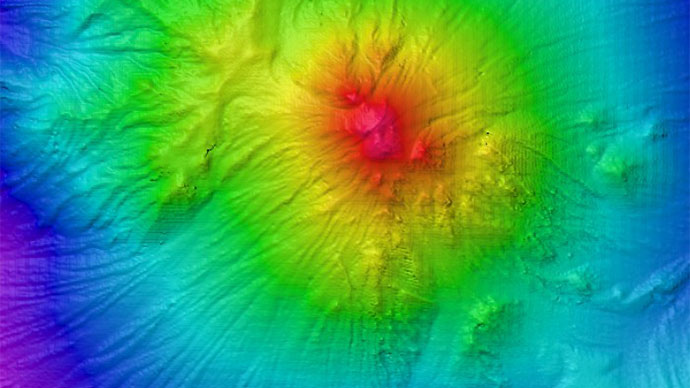
Read moreJune 26, 2010 | By Mashkoor Malik, Elizabeth Lobecker, Elaine Stuart, Colleen Peters, and Nicola Verplanck
 seamount looking from the northwest. The underwater volcano rises around 3,800 meters (12,467 feet) from the seafloor.")
June 24 marked the start of the first expedition where all of the sensors on NOAA Ship Okeanos Explorer will work in unison to explore unknown depths in Indonesian waters. The hull-mounted multibeam sonar (Kongsberg EM302, 30 kHz) will be used to collect data to produce baseline bathymetric maps, which ocean scientists – including marine geologists, biologists, oceanographers, and ecologists – will use as a backdrop to study the seafloor. Kawio Barat was one of the first underwater seamounts mapped during this cruise. The impressive volcano rises some 3,800 meters (12,467 feet) above the surrounding seafloor. Images from mapping results over Kawio Barat were shared with scientists based in Jakarta and Seattle in real time, from which CTD cast sites and remotely operated vehicle dive sites will be selected.
Read moreJune 25, 2010 | By Michael A. Purwoadi

Full operations at the Jakarta Exploration Command Center (ECC) commenced yesterday, June 24, with the start of the INDEX-SATAL 2010 expedition. During the expedition, scientists based at the Jakarta ECC will monitor video and data feeds coming off of NOAA Ship Okeanos Explorer and the Agency for the Assessment and Application of Technology's research vessel, Baruna Jaya IV, as both vessels explore areas known to be very volcanically active around the Sangihe and Talaud islands. With the ability to monitor live incoming feeds, and communicate in real time with the Okeanos Explorer, scientists and participants at the Jakarta ECC are utilizing telepresence to explore the ocean for the first time!
Read moreJune 24, 2010 | By Cameron R. Hume

Yesterday, I had the pleasure of visiting NOAA Ship Okeanos Explorer in Bitung and participating in the opening ceremonies hosted by the Governor of North Sulawesi. The ship’s arrival at Bitung is the latest chapter in a sustained two-year long effort to build an ocean exploration science partnership between Indonesia and the United States and to bring the Okeanos Explorer to Indonesia for the first-ever visit to Indonesia of a U.S. government civilian research ship.
Read moreJune 23, 2010 | By Jeremy Potter

The Governor of North Sulawesi and the Mayor of Bitung, Indonesia, really know a thing or two about hospitality. It’s been more than 48 hours since the ‘Welcoming Ceremony’ for the NOAA Ship Okeanos Explorer and onboard personnel ended, but we are still practically speechless.
Read more