by Kelley Elliott, NOAA Office of Ocean Exploration and Research
David Butterfield, Joint Institute for the Study of the Atmosphere and Oceans, University of Washington and NOAA/PMEL
June 29, 2010
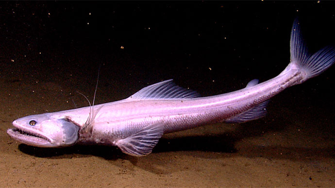
Footage captured on June 29, 2010, during the first ROV dive of INDEX-SATAL 2010 down to the Kawio Barat volcano. The video shows some of the stunning marine life encountered during the dive. A field of clams (possibly chemosynthetic?) is imaged shortly before the ROV came across a hydrothermal vent plume. Video courtesy of the NOAA Office of Ocean Exploration and Research, INDEX-SATAL 2010. Download video (mp4, 54.4 MB).
After many months of planning and preparation, today marked the first day of full telepresence operations at the Exploration Command Center (ECC) based in Seattle, Washington. Scientists and other participants began arriving at 1700 local time to an office space at the NOAA Pacific Marine Environmental Laboratory, set-up with six large, high-definition monitors; several computers; and an RTS Intercom Unit enabling real-time communication with NOAA Ship Okeanos Explorer and other shore-side ECCs.
Scientists and expedition participants began setting up computers around a conference table and logging into a variety of online collaboration tools used to communicate and share information with other scientists and participants in Jakarta, Indonesia and on the Okeanos Explorer and a handful of experts and students joining from other locations. Large, high-definition monitors in the front the ECC streamed live footage from NOAA Ship Okeanos Explorer, located thousands of miles away in the Celebes Sea.

Today marked the first day of full operations during INDEX-SATAL 2010 at the Seattle Exploration Command Center. Scientists stand watch as live footage of the seafloor captured by the ROV streams to shore in real time. Image courtesy of the NOAA Office of Ocean Exploration and Research, INDEX-SATAL 2010. Download larger version (jpg, 3.4 MB).
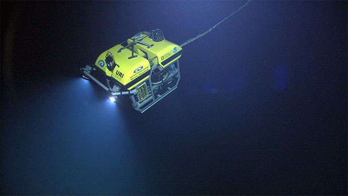
Meanwhile on the Okeanos Explorer, the remotely operated vehicle (ROV) team and members of the ship’s crew have just finished breakfast and are making preparations to deploy the Little Hercules ROV down to Kawio Barat – an undersea volcano in the Celebes Sea 1,900 to 5,500 meters (6,233 to 18,045 feet) deep – to search for hydrothermal vents and associated ecosystems. High-definition cameras located around the ship capture the action, and at any time as many as three video feeds showing what is happening in real time are sent from the ship to participants on shore.
Today, these video feeds are being pulled into both the Jakarta and Seattle ECCs, where scientists are standing watch, waiting to provide input and information about the seafloor and habitats being explored by the Little Hercules ROV. Scientists in both locations watch as the ROV is deployed over the side of the ship and begins its descent through deep water to an area near the crest of the Kawio Barat volcano. Shortly after deployment, a daily meeting between participants in all three locations to review the current dive plan and discuss plans for the following day begins.

The Little Hercules ROV descends through deep water down to Kawio Barat – an undersea volcano in the Celebes Sea 1,900 to 5,500 meters (6,233 to 18,045 feet) deep – to search for hydrothermal vents and associated ecosystems. Video collected by a high-definition camera on Little Hercules and the camera platform are sent to the ship, to satellites in space, and to Exploration Command Centers on shore in real time. Image courtesy of the NOAA Office of Ocean Exploration and Research, INDEX-SATAL 2010. Download larger version (jpg, 1.5 MB).

The slope explored during today’s dive on Kawio Barat was covered by dark volcaniclastic sediments – fine bits of pulverized rock produced by explosive lava eruption higher up the slope. Image courtesy of the NOAA Office of Ocean Exploration and Research, INDEX-SATAL 2010. Download larger version (jpg, 1.7 MB).
About an hour later, the ROV arrives at the seafloor and begins ascent of the upper western slope toward the summit, situated about 250 meters (820 feet) higher than our starting depth. Based on evidence from several water column profiles around the summit, we fully expect to find active hydrothermal vents on this volcano. As we work our way up the slope, scientists based in Seattle, Oregon, Massachusetts, and Jakarta – each with expertise in submarine and hydrothermal systems – recognize promising signs that the area very recently, and perhaps still, contains active hydrothermal venting. They read the signs and provide guidance on what direction the ROV should head to find active vent areas.
The entire slope along our track is covered by dark volcaniclastic sediments, fine bits of pulverized rock produced by explosive lava eruption higher up the slope. The surface of the sediments is often covered by bright white or orange coatings produced when warm fluids percolate up through the sand-like sediments and encounter cold seawater. The iron and sulfur carried by the warm fluids produce orange or yellow-white coatings that stand out vividly against the dark background. In some places, we see rocky outcrops standing above the sediments, and many of the rocks are brightly colored from hydrothermal alteration.

Rocky outcrops standing above the sediment like you see here contain brightly colored areas, altered from past hydrothermal activity. Image courtesy of the NOAA Office of Ocean Exploration and Research, INDEX-SATAL 2010. Download larger version (jpg, 2.4 MB).

Many of the rocks we see exposed on the western slope of Kawio Barat are highly vesicular, meaning they are full of holes left by gas bubbles present in the lava as it froze during eruption. The lavas here must have been exceptionally rich in gas to produce so many gas bubbles at a depth of nearly 2,000 meters (6,562 feet). Image courtesy of the NOAA Office of Ocean Exploration and Research, INDEX-SATAL 2010. Download larger version (jpg, 2.0 MB).
None of the areas that we see along the ascending transect, however, are actual, active hydrothermal flow. They are signs of potentially very recent warm conditions, but nothing we see on the western slope can produce the intense hydrothermal plumes we detected in recent days with the CTD.
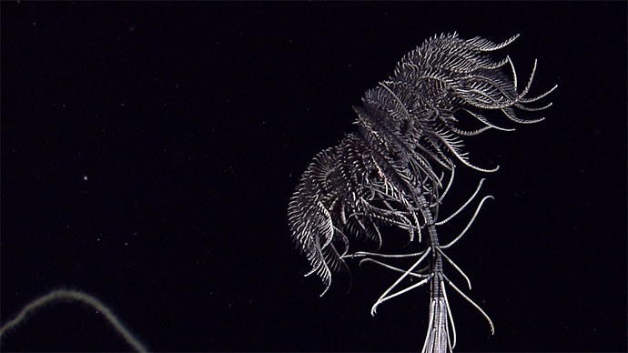
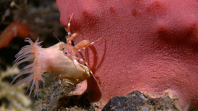
Our ascent takes us all the way up to the summit ridge where we see live clams sitting on top of sediments. Are they chemosynthetic? By the time we reach the summit ridge, we are all wondering why we haven’t seen any active venting, as the dive time is quickly running out. As we pass the point where a perpendicular ridge crosses the ridge we are traversing, with only 15 minutes remaining before we have to leave the bottom, large billowing clouds of light-colored particles appear. We have found the smoking gun, and all of us watching in Seattle, Jakarta, and on board the Okeanos Explorer are excited and looking forward to finding the source of these vents on the next dive.

The surface of the sediments seen during the dive was often covered by bright white or orange coatings produced when warm fluids percolate up through the sand-like sediments and encounter cold seawater. The iron and sulfur carried by the warm fluids produce orange or yellow-white coatings that stand out vividly against the dark background. Image courtesy of the NOAA Office of Ocean Exploration and Research, INDEX-SATAL 2010. Download larger version (jpg, 1.8 MB).

During the ROV dive, we ascended up a summit ridge where, in the last hour of the dive, we saw live clams sitting on top of sediments. Our dive revealed many signs that the area previously hosted active hydrothermal venting and these clams might be one more such sign; however, we were unable to determine whether these clams are chemosynthetic with the imagery collected. Image courtesy of the NOAA Office of Ocean Exploration and Research, INDEX-SATAL 2010. Download larger version (jpg, 1.7 MB).
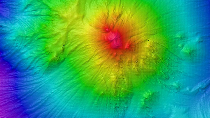
Animation showing EM302 multibeam data acquired via NOAA Ship Okeanos Explorer during the INDEX-SATAL 2010 expedition, overlain on satellite bathymetry. The animation zooms in to show the Little Hercules ROV descending through the water column to the Kawio Barat submarine volcano. Video courtesy of the NOAA Office of Ocean Exploration and Research, INDEX-SATAL 2010. Download video (mp4, 32.5 MB).