The Columbia River meets the Pacific Ocean in an idyllic setting on the coast of Washington and Oregon.
June 26-July 13, 2001
Summaries
Daily Updates
In the spirit of discovery defined by the original Lewis and Clark Expedition, ocean scientists explored the little known submarine abyss of Astoria Canyon. Just 10 mi offshore from the mouth of the Columbia River, the most westward reach of the famous 19th century explorers, these depths were virtually unexplored. The region’s active tectonic setting suggested the potential for fluid or methane seeps in the canyon. Its sheer depth has stood as a "sentry," guarding the canyon from human intruders, and intrigued the researchers who hoped to discover untouched biological havens and even previously unknown species.
The modern-day explorers plumbed the depths of Astoria Canyon with many technological tools that were unimagined in the time of Lewis and Clark. Sonar, hydrophones, high-resolution video, and a remotely operated vehichle (ROV) called ROPOS are just a few of them. Once finished in the canyon, the exploration party headed to nearby Heceta Bank, a heavily fished underwater plateau. There, they assessed and compared its habitat with the nearly pristine environment of Astoria Canyon.
Background information for this exploration can be found on the left side of the page. Daily updates are included below. More detailed logs and summaries of exploration activities can be found on the right.
Updates & Logs
SUMMARIES
Click images or links below for detailed mission logs.
 Observations at Heceta Bank, July 4 � July 13, Phase 3 Summary
 After completing the exploration of Astoria Canyon, another exploration phase began when the modern-day Corp of Discovery embarked from Astoria, Oregon, with a 25-member scientific and engineering team aboard the Ronald H. Brown to explore the geology and habitats of invertebrates and commercially important fishes on Heceta Bank. Read a summary of this exploration.
 Visiting the Frontier: Diving into Astoria Canyon, June 26 – July 3, Phase 2 Summary
Much of the expedition's significance lies in its interdisciplinary scientific approach to ocean discovery. Geologists, ichthyologists, invertebrate zoologists, physical oceanographers and fisheries biologists
teamed to study the geological forces at work and ecological relationships of this unexplored submarine realm.
Get a sweeping overview of what this diverse group of scientists discovered from Waldo Wakefield and Bob Embley, co-chief scientists of the expedition. Also
read an account by Richard Hill, award-winning science reporter for
The Oregonian, and
 view a short video clip
 of underwater footage and launching the ROV.
 Scientists' Observations (Phase 2 of the Expedition)
 Expedition scientists explored Astoria Canyon for eight days between June 26 and July 3 using ROPOS' video cameras and sampling instruments. They also conducted bio-acoustic sampling, mid-water trawls, CTD casts, and other scientific procedures.
Read their preliminary observations of this historic ocean expedition.
 Uncharted Territory: Mapping Astoria Canyon, May 29 – June 16, Phase 1 Summary of the Expedition
Before heading to sea to explore Astoria Canyon with a remotely operated vehicle (ROV), scientists had to reconnoiter and map the submarine terrain. They did this on a survey cruise using sidescan sonar to identify the best places to conduct ROV transects.
Learn the results of this cruise.
 Photo Log
This is a collection of all images from daily logs of the Lewis and Clark Legacy Expedition. It contains colorful photos of fishes, invertebrates, geological features, equipment used on the expedition, and three-dimensional images of Astoria Canyon and Heceta Bank.
Check out some of the unusual scenes and beautiful creatures seen on the expedition.
DAILY UPDATES
July 13 To celebrate completion of this voyage of discovery, an Open House aboard the
Ronald H. Brown and a press conference with the ocean explorers were held in Newport, Oregon. The public was able to meet the scientists and crew who took part in this expedition and see equipment that was used. The press heard first hand accounts of what the explorers observed.
Read about this final event of the expedition.
July 12 The final ROPOS dive ended shortly before midnight on July 11, signalling the end of the Lewis and Clark Legacy Expedition. The ROV traveled over some of the most complex geologic features of the northern part of Heceta Bank during this mission and made an interesting discovery about one of the many species of rockfish.
Learn what scientists discovered.
July 11 The fifteenth and final ROPOS dive of the expedition began late this morning in a geologically complex region of northern Heceta Bank, where explorers found more seeps. On the previous dive the evening before, on the southwest edge of the bank while crossing a vast mud plain, scientists discovered an unusual seep, unlike any of the others seen earlier.
Find out why this one was different.
July 10 Curiosity brought the explorers to parts of the bank not previously visited and back to an area of seeps that they discovered on the first Heceta Bank ROPOS dive on July 4th. Today they found more extensive seep habitat.
Share a part of what they found, and
read an interview with Keith Bosley, research fisheries biologist.
July 9 The log for today covers two dives of the remotely operated vehicle ROPOS. During the nighttime geological survey, explorers visited the possible site of an ancient shoreline and exposed headland at a time when the sea level was much lower. Earlier, more fish transects, this time over massive outcrop ridges and fields of large boulders, revealed crinoid "forests" that shared ridges with seastars, brittlestars, nudibranchs, and numerous species of sponges.
Find out what else oceanographers saw.
July 8 During ROPOS dive number seven, the explorers located extensive carbonate crusts and small carbonate chimneys that provide microhabitats for fish and substrate on which invertebrates can attach. They also saw small bacterial mats, where active gas bubbling was observed.
Find out more and
read an interview with Jennifer Bloeser of the Pacific Marine Conservation Council.
July 7 Once again, the winds died down, and scientists returned to recover the fish traps from the previous day. Geologists on board tested an acoustic remote sensing system known as Imagenex, and deployed the ROV ROPOS to study some interesting areas of heavily jointed and folded features. It was a busy day for the scientists aboard the Lewis and Clark Legacy Expedition.
Read all about it and view some very interesting images.
July 6 After a day of bad weather, the remotely operated vehicle ROPOS returned to the water to deploy fish traps and conduct fish transects. The winds had returned by evening, however, so ROV operations were suspended and the scientists turned to bioacoustic sampling.
Learn what scientists discovered and
read a profile of Captain Donald A. Dreves, Commanding Officer of the NOAA Ship
Ronald H. Brown.
July 5 Late yesterday evening, the winds kicked up 10-ft seas, making launch and recovery of the ROV ROPOS too dangerous. Consequently, today's activities began with transects using the bioacoustic profiler and an acoustic Doppler current profiler. Read about these activities, as well as the results of the previous day's second ROPOS mission.
July 4 In the early morning hours, the NOAA Ship
Ron Brown steamed into the waters of Heceta Bank, 30 miles off the coast of central Oregon. The scientists on board lost no time, deploying the remotely operated vehicle ROPOS shortly after dawn to continue the habitat-based fisheries research that began there in 1988.
Find out about and see some of the interesting marine life encountered during the expedition's first dive on the bank.
July 3 After eight days at sea, explorers returned to the port of Astoria, Oregon. Their final day at Astoria Canyon marked the deepest dive of the adventure, spectacular geologic formations, and the most abundant marine life of the expedition. Following an exchange of scientific personnel in Astoria, the NOAA ship
Ron Brown headed to Heceta Bank for another journey of discovery.
Learn about the final ROPOS dive in Astoria Canyon.
July 2 Today,
the remotely operated vehicle
ROPOS made a pair of dives, one to search for a geologic fault and another to study landslides in the canyon. The very nature of submarine geologic exploration led to interesting invertebrate observations.
Learn about these dives of the expedition, and
get the perspective of Waldo Wakefield, expedition co-chief scientist.
July 1 The expedition to Astoria Canyon has only three more days before explorerers head south to Heceta Bank, a heavily fished ocean plateau. Weather and equipment have been cooperating for the past several days during the dives in the canyon, and a film crew has been busy documenting all aspects of the expedition.
Hear from the cameraman and
read an interview with marine biologist Mary Yoklavich, an expert on rockfish.
June 30 Discovery is not limited to daylight hours in ocean depths where sunlight never penetrates. During the third dive of the remotely operated vehicle (ROV) ROPOS, scientists studied fish by day and geology and invertebrates at night. Other operations over the last 24 hours include ocean conductivity, temperature and depth measurements, bioacoustic profiling, and mid-water trawling.
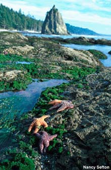
See the sea cucumbers and colorful sea stars in the depths of Astoria Canyon,
and
read an interview with marine ecologist Brian Tissot.
June 28 The seas calmed, and ROPOS made its first dive to the bottom of Astoria Canyon, nearly 2,000 ft deep! Bioacoustic sampling results from the previous day revealed schools of hake and rockfish in the mid-water realm.
Check out what scientists are discovering.
June 27 The launch of the remotely operated vehicle (ROV) ROPOS to explore the depths of Astoria Canyon has been delayed due to adverse weather conditions. The bioacoustic profiler was deployed, however, to test the system in full-operation mode. Scientists will be conducting acoustic transects across the axis of the canyon this evening, and anticipate seeing the deep-scattering layer organisms, such as krill.
Learn more about Astoria Canyon from the expedition's Teacher-at-sea, and
read an interview with biologist Bill Pearcy.
June 26 The NOAA Ship
Ronald H. Brown will the leave the port of Vancouver, British Columbia, and sail to Astoria Canyon, approximately 10 mi offshore from the mouth of the Columbia River, to begin the expedition.
Read about the first day of this 18-day expedition.
Sign up for the Ocean Explorer E-mail Update List.


