


ROPOS samples a carbonate chimney at 275 m depth. These limestone structures provide microhabitats for fish and invertebrates. Click image for a larger view and to learn more.
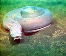
Pacific hagfish, pictured here at 280 m depth, are found from shallow depths down to 400 m. During night transects on July 7, a significant portion of the hagfish were observed resting on the bottom in this curled position. Click image for a larger view and to learn more.
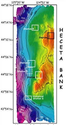
Areas of submersible dives (historical dives) conducted in 1988, 1989, and 1990. During this final phase of the Lewis and Clark Legacy Expedition, dives are being conducted with the ROPOS ROV to repeat transects made during the earlier dives. Comparing these data will reveal information about changes in fish and invertebrate abundance over the past decade. Click image for a larger view.
Carbonate Crusts and Chimneys
July 8, 2001
Susan Merle, Geological Research Assistant
Cooperative Institute for Marine Resource Studies Program, Oregon State University
Vents Program, Pacific Marine Environmental Laboratory, NOAA
and
Curt Whitmire
Cooperative Institute for Marine Resource
Studies
Oregon State University
When ROPOS went back in the water yesterday morning for dive R608, the sixth on Heceta Bank, a series of fish transects were run at historical station 1, on the northern bank in water depths ranging from 70 to 85 meters. The seafloor consists of jointed bedding planes that form distinct ridge topography. Although the total numbers fish were relatively low, high numbers of juvenile rockfish were observed in some places. The dive took place from 1022 - 1646 PDT. Samples taken on the dive include: 2 rocks, 2 urchins, 1 polychaete and a sponge. The ROV was then brought on deck as we transited west for the evening's geobiology traverses.
ROPOS returned to the water on July 7 at 8 pm PDT. Dive R609 took place in an area due west of the previous dive, but in deeper water. The objectives of the dive were to: (1) investigate and sample several "pockmarks" west of the bank's seaward edge, and (2) investigate the nature of deepwater rockfish habitats. The seep area explored is seaward of the shelf break, in water depths ranging from 250-525 m. The sea floor in this area is mainly mud-covered. In some areas, shallow depressions of 100-200 m in diameter are found. Dives during the summer 2000 field season revealed that these were probably formed by the expulsion of gas produced within the underlying sediments. These pockmarks are characterized by extensive carbonate precipitation (limestone) that forms crusts and small chimneys. The carbonate structures provide microhabitats for fish and substrate to which invertebrates can attach. In some places, specialized chemosynthetic bivalves (clams) utilize energy derived from the methane hydrogen sulfide that seeps out. At the two seep sites visited on Dive R609, we encountered extensive carbonate crusts and chimneys, and small amounts of bacterial mat, where active gas bubbling was observed.
ROPOS then proceeded to deeper water to investigate habitats on the continental slope. At one location with a strong acoustic return, deepwater weathering of outcropping rock was observed, with boulders forming from the slow degradation of the rock. Ground-truthing of such areas observed on high-resolution maps is important for understanding the nature and extent of deepwater habitats for fish and invertebrates. Samples collected on the dive included a niskin water sample, several gastropods (snails, etc.), a sea pen, a sea urchin, a brittlestar, two crinoids, a sediment core, and a piece of a carbonate chimney.
At 7:57 am PDT on July 8, nearly 12 hrs since its descent, the ROV was recovered. We have now moved on to dive R610 for more fish transects at historical station 4.

Jennifer Bloeser, Scientific Coordinator of the Pacific Marine Conservation Council.
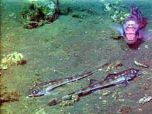
Two unidentified poachers (foreground) and a sharpchin rockfish (upper left) observed in the vicinity of the carbonate outcrops during ROPOS dive R609 on July 7. Click image for a larger view and to learn more.
Science Coordinator
Pacific Marine Conservation Council (PMCC)
Ocean Explorer Team: What is your background, and how did you come to work for the Pacific Marine Conservation Council?
Jennifer Bloeser: I have a master's in natural resources in fisheries from Humboldt State University. I did my thesis on an anomalous population of California halibut. It allowed me to work with a resource that was primarily exploited recreationally at that time; thus, I got to interact with fishermen and some management people. I decided that when I completed my degree, I wanted to combine science, management, and conservation in a way that would effect change. The PMCC offered me that opportunity.
Ocean Explorer Team:What are the general goals of the PMCC in relation to groundfish issues on the West Coast?
Jennifer Bloeser: Basically, our mission encompasses sustainable fisheries and coastal economies. Right now, we're primarily working on three issues. One is quantifying total mortality with the groundfish fishery, particularly through bycatch, and having an observer program. The second deals with stakeholder participation in the various marine reserve processes happening on the West Coast, such as working with coastal communities to figure out how they want to have a voice in these processes. The third issue involves developing ways to transition the fleet through this "disaster" and end up with a sustainable, balanced fishery. We're gathering data from different communities to discover what they feel is necessary to maintain their infrastructure and the fishing part of their economy.
Ocean Explorer Team: How does this project dovetail with accomplishing those three goals?
Jennifer Bloeser: I think this project helps to accomplish the overall goal of the PMCC, which is having a sustainable resource. I also co-chair the habitat steering group for the Pacific Fishery Management Council. In that arena, I'm working on a lot on habitat issues, particularly as they pertain to overfished species. What we do out here will help to fill the gaps of habitat information for several rockfish species. We do not have critical habitat or habitat areas of particular concern identified for rockfish, which are especially pertinent to overfished species. This work is critical to understanding the interactions between fish and their habitat.
The persistence of the staircase over more than a decade and its coherence for more than 1000 km across the Canada Basin not only indicates geothermal heating but also suggests very little motion at these depths. An interesting feature of the basin is that the well-formed staircase structure is not observed near the edges of the deep basin. This is likely a sign of more mixing and more vertical transport of heat. We hope that the precise instruments on our mooring that will provide us with continuous readings of temperature in the bottom and staircase layers will give us more clues.
With this data we hope to find out how and where the geothermal heat is escaping. How long has this water been in isolation? How did it get there and where did it come from? Are the structures we observe likely to change significantly in the near future? What are the remarkable physical processes that are occurring at these depths? Answers to these questions will further our understanding of the role of the deep water and its relationship to the shallow and intermediate depth waters of the Arctic Ocean, which, as we already know, play a vital part in the global ocean and climate system.
Sign up for the Ocean Explorer E-mail Update List.