


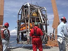
The remotely operated vehicle ROPOS (inside the cage) is being used to explore Astoria Canyon. High seas delayed its deployment on the first full day of the expedition. Click image for larger view.
The Geology of Submarine Canyons
June 27, 2001
Jeff Goodrich, Teacher-at-sea
Earth Science Teacher
Lake Oswego High School
Lake Oswego Oregon
and
Susan Merle, Geological Research Assistant
CIMRS Program, Oregon State University
Vents Program, Pacific Marine Environmental Laboratory, NOAA
Traveling through the night in 15-ft swells, the NOAA Ship Ron Brown and its team of ocean explorers arrived at Astoria Canyon just before 10 this morning. The canyon resembles a huge gash running perpendicular to the continental shelf, and stretches some 25 nautical mi, sloping westward toward the deep abyss of the Cascadia Basin. Here, at the deep end of the canyon, sediment from the Columbia River spreads out over the abyssal plain as the Astoria Fan.
Submarine canyons are not uncommon. More than 100 of them nick nearly all of the world's continental shelves. Created through the processes of erosion, they look like terrestrial canyons. Thus, they were once thought to be the result of fluvial (river) processes during periods of glaciation and lower sea levels. Scientists now know that this is only part of the story. Global sea level has never fallen below 200 m, so the Columbia River could not have cut the bottom portion of the Astoria Canyon, which lies 2,000 m below sea level. Triggered, perhaps, by earthquakes in the Cascadia Subduction Zone, huge, avalanche-like sediment movements, called turbidity currents, tear down the continental slope, abrading and carving the canyon. These currents may move up to 27 km per hr, and have been responsible for the failures of many trans-ocean communication cables.
The sediments responsible for turbidity currents in Astoria Canyon come mainly from the Columbia River. A portion of the sediment in this area, however, probably came from the Missoula Floods, a catastrophic series of Pleistocene floods from western Montana. These floods tore across eastern Washington, funneled through the Columbia River Gorge, and terminated at the mouth of the Columbia River, depositing an unknown quantity of material into the canyon area and beyond. These deposits are of interest to the geologists on board. One of the things they hope to do is quantify the amount of material deposited from the ancient floods.
Read the interview below with Bill Pearcy, of Oregon State University, for a biological oceanographer's perspective on Astoria Canyon.
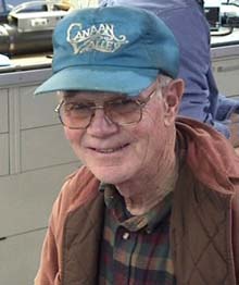
Bill Pearcy, a biologist at Oregon State University, participated in one of the first rearch cruises to Astoria Canyon in the early 1960s. Click image for larger view.
Interview with Bill Pearcy, Biologist
Oregon State University
June 27, 2001
Ocean Explorer Team: What type of oceanographic research do you do?
Bill Pearcy: I'm a biological oceanographer. I've worked in estuaries and the coastal zone, and have done a lot of work in the deep sea. I've covered it all working mostly with the big stuff, nekton. I've been going to sea since I came to Oregon State in the early 1960s. We've participated in many cruises, mostly in the coastal ocean up to maybe 100 mi offshore.
Ocean Explorer Team: Have you worked at Astoria Canyon before this cruise?
Bill Pearcy: Yes. In the early 1960s, I worked with people from the National Marine Fisheries Service. They were doing surveys just south of the canyon for rockfish and other benthic fish in 200 m or less, and caught lots of rockfish. We were really surprised when we looked at the stomachs of the rockfish. We could see that they wee eating shellfish and mesopelagic fish, which are usually found in deeper water (usually 500 m or more). It was a surprise to see these deep-sea fishes. We assumed that updraft circulation in the canyon brought these deep-sea fishes up to the surface, which made them "easy pickins" for the shelf rockfish. We made some suppositions about circulation in the canyon and how it was causing advection.
Ocean Explorer Team: How does your previous work tie in with this cruise?
Bill Pearcy: I'm interested in what's going on during this cruise because we're studying physics, biology, geology and acoustics all together as a package to try to figure out how the deep water is getting up here. It's a follow-up to what we did a long time ago, studying the interactions between the canyon and both the shelf and deep-sea fauna. It all comes together in these submarine canyons. It's a fascinating spot, and we know so little about it. All we've done here is a few tows with bottom trawls on the shelf near the canyon. All of the rest is unexplored. We don't know what's in the deep canyon and how these deep fish come into shallow areas. It's a fascinating area.
Sign up for the Ocean Explorer E-mail Update List.