


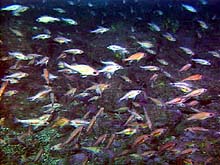
A large school of pygmy rockfish and others, probably small redstripe rockfish, were sighted on the shallow southern portion of Heceta Bank at 77 m depth. Click image for larger view.
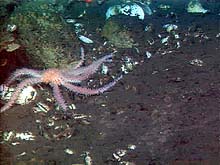
On Dive R614, ROPOS collected an unidentified species of seastar, pictured here amid bivalve and gastropod shells, at 490 m depth. Unusual morphological features of this specimen are tube feet that completely surround its appendages. Click image for larger view.
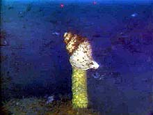
This gastropod appears to be performing a balancing act. In reality, it is depositing numerous egg casings to form this pinnacle-like spire. Click image for larger view.
Seeps and Spires
July 10, 2001
Susan Merle, Geological Research Assistant
Cooperative Institute for Marine Resource Studies Program, Oregon State University
Vents Program, Pacific Marine Environmental Laboratory, NOAA
and
Curt Whitmire
Cooperative Institute for Marine Resource
Studies
Oregon State University
ROPOS was in the water for Dive R613 from 12:57 pm to 6 pm PDT on July 9. As with most of our previous daytime dives, conducting quantitative fish transects was the main objective. The transects took place on a section of the bank that we had not visited previously. The habitat was composed of boulder fields between topographically high ridges. Sand and mud were interspersed between many of the features. Several large schools of fish were spotted, including juvenile rockfish, and adult yellowtail and pygmy rockfish. Large densities of basketstars, seastars and sponges were present in the high current areas on the rock ridges. Samples included a basketstar, a crinoid, sponges, gorgonians (corals), brittlestars, and two water samples.
Between Dives R613 and R614, Jackie Popp-Noskov deployed the bioacoustic profiler and gathered more data while transiting south. Dive R614 began on July 9 at 8:46 pm, south of the shelf break in water depths ranging from 400 to more than 500 m. The dive began in an area that Bill Barss and Steve Parker, of the Oregon Department of Fish and Wildlife, believed to be a petrale sole spawning site. Unfortunately, petrale were not spotted on our transect. Because the peak spawning period for petrale sole is in January and February, they may not have been in this area (or depth range) during the current summer season.
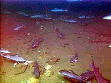
We then proceeded southwest to the reflective area first visited on Dive R603 (July 4), the first ROPOS dive on Heceta Bank. The discovery of seeps with chemosynthetic clams in the vicinity brought us back to this site. This latest survey revealed a much more expansive seep habitat, consisting of dense communities of bivalves, gastropods (e.g., Neptunia), and other invertebrates. One of these sites was more than 100 m across. Numerous gastropod egg masses, thought to be spawned by predatory Neptunia, were formed into small, pinnacle-like spires. Patches of white filamentous bacterial mat were observed where fluid flow was probably strongest. Samples collected included rocks, bivalves, gastropods, black crinoids, an anemone, a seastar, an octocoral, bacterial mat, and water. The dive ended at 8:09 am PDT on July 10.
ROPOS has returned to the water on a portion of the southeast bank, again in new territory. More tomorrow.
Keith Bosley, a NOAA research fisheries biologist.
The ROPOS camera captured this school of 50 or more sablefish in the vicinity of the seeps visited on Dive R614. Click image for larger view.
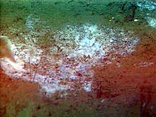
Patches of white filamentous bacterial mat were observed where fluid flow was probably strongest, in the seep area visited on Dive R614. Click image for larger view.
An Interview with Keith Bosley
Research Fisheries Biologist
NOAA, National Marine Fisheries Service
Ocean Explorer Team: What is your background?
Keith Bosley: I went to graduate school at Rutgers University in New Brunswick, NJ, and received an MS in environmental science with emphasis in marine biology. My thesis topic was aimed at conducting laboratory experiments to validate some of the assumptions that are made when people use stable isotope techniques in field studies of food webs. The main thrust of my thesis work was that I reared larval fish in the laboratory in order to look at the length of time it took for a consumer to acquire the isotopic signature of its diet. If you have a highly mobile animal or one that feeds on multiple trophic levels, it is likely to encounter any number of diets that are isotopically distinct. If you want to learn anything about the importance of one habitat versus another or one diet versus another, you need to know the length of time it takes for an animal to acquire the signature of its diet. This becomes useful for trying to determine at what trophic level an animal is feeding, because there is a relatively predictable relationship between what you look like and what your diet looks like. In other words, "You are what you eat" -- at least if you're a fish.
Ocean Explorer Team: How did you come to be involved with this project?
Keith Bosley: I'm still technically a research associate for Rutgers University, and I'm on an intergovernmental personnel agreement (IPA) to work with the National Marine Fisheries Service (NMFS) in Newport, Oregon. I knew Dr. Waldo Wakefield, co-chief scientist of this expedition, so when the opportunity presented itself and he left Rutgers to work in Oregon, we worked out this arrangement to bring me to Oregon. It seems like a data-poor world out here on the West Coast, more so than on the East Coast. There are many questions that need to be addressed. I'm trying to collect samples of multiple trophic levels, starting with the phytoplankton in the water that serve as the basis for the food web. I'm also collecting zooplankton, small fish, and rockfish, to figure out the extent to which fish associate with one habitat or another.
It would be interesting to see the data from Astoria Canyon, because there, the Columbia River causes this massive flushing of terrestrial production into the ocean. The Canyon also has the advection of deep, nutrient-rich water and highly productive shelf water. All of these are potential sources of carbon, so we need to see how they manifest themselves throughout the food web, depending on different habitats. It is also interesting here on Haceta Bank, because there is upwelling of deep, nutrient-rich water into this shallow, highly productive shelf area. We need to conduct separate food- web studies, and, ultimately, compare the two areas. It adds an interesting piece of information to this study, because the whole thrust of this project is looking at habitat associations. Having a stable isotope component to this research could potentially support, or maybe clear up, our findings.
Sign up for the Ocean Explorer E-mail Update List.