


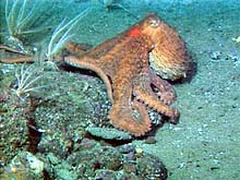
An octopus observed at 94 m depth on central Heceta Bank. Octopi have the ability to change coloration to blend in with their surroundings. This one was caught off guard, and is none too happy about it. Click image for larger view.
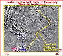
This image shows central Heceta Bank dives R605 and R607 overlaid on the topography. This portion of the bank represents outcrops of heavily folded and jointed bedrock. The folds are a series of ridges and troughs. Click image for larger view.
Pencil-beam Scanning and Oases of Life
July 7, 2001
Susan Merle, Geological Research Assistant
Cooperative Institute for Marine Resource Studies Program, Oregon State University
Vents Program, Pacific Marine Environmental Laboratory, NOAA
and
Curt Whitmire
Cooperative Institute for Marine Resource
Studies
Oregon State University
The weather was much more manageable during operations on July 6. The remotely operated vehicle (ROV) ROPOS went back in the water around 11:20 am PDT for Dive R607, and headed to the bottom in the vicinity where the fish traps were previously deployed. The three fish traps were engineered so that when the weights were released, a float would send them floating to the surface. Several factors, however, delayed the recovery of the traps until a later dive.
The geologists on board prepared for some test runs of an acoustic remote sensing system known as Imagenex, which is mounted on the ROV. Imagenex is a "pencil-beam" scanning sonar device, which makes sonar sweeps from side to side as the ROV traverses, resulting in a high-resolution zig-zag pattern of depth soundings under the ROV track. This is our first Imagenex survey on Heceta Bank, but in the past, we have used Imagenex to collect high-resolution bathymetry at several sites on the Juan de Fuca Ridge. We completed two test runs of the Imagenex system, one in an east-west direction and the second in a west-east direction. When analyzed, this system produces high-resolution imagery of the sea floor, which will aid in classifying the bottom types of Heceta Bank.
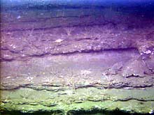
The terracing visible on this rock outcrop is caused by differential erosion. The less resistant rock layers erode away, sometimes forming overhanging ledges that offer protection for juvenile rockfish from predators and strong currents. Crinoids cover this terrace at 93 m depth. Click the image for a larger view.
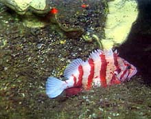
A tiger rockfish perches itself in a crevice between two boulders at 92 m depth. At upper left is a large yellow sponge. Click the image for a larger view.
Next, our nighttime dive efforts transitioned to doing geological surveys of some interesting areas of heavily jointed and folded features. At the beginning of these transects, the ROV passed over a sandy sea floor with intermittent patches of cobbles and boulders. Oftentimes, the terrain appeared as a barren wasteland, but occasionally provided oases for invertebrates such as crinoids, brittlestars, and sponges, as well as ratfish and various species of rockfish.
The sandy terrain turned to hard, flat bottom, which, on occasion, was pushed up into large outcroppings. These outcroppings appeared to be composed primarily of mudstone, and showed evidence of boring organisms. The burrows of these organisms create weaknesses in the surface mudstone, causing pieces to crumble off, and sometimes forming overhangs that offer protection to fish from predators and strong currents.
As the sea level rose after the last Ice Age, the shoreline moved progressively eastward to its present-day location. We sampled many rocks and sediments in this area that may provide compelling evidence for the existence of an ancient shoreline to the west of the dive area. Additionally, many invertebrates were sampled, including a couple of species of seastars, a brittlestar, an anemone, a sponge, and an unusual translucent cnidarian known as Caryophyllidae. Dive R607 ended around 7:45 am PDT. After a short break for routine maintenance, ROPOS was back in the water at 10:22 am PDT on July 7, to begin another series of fish transects near historical station 1.
Sign up for the Ocean Explorer E-mail Update List.