


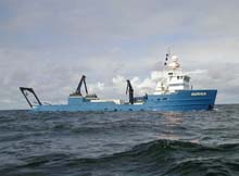
The Auriga conducts a sonar survey of Astoria Canyon. Photo by Jamie Lauritzen. Click image for larger view.
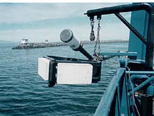
The white objects at left are multibeam transducers. The cylinder on the canted extension (center of photo) is used to navigate a deep-tow sidescan sonar instrument. Click image for larger view.
Uncharted Territory: Mapping Astoria Canyon (Phase 1 of the Expedition)
May 31 – June 13, 2001
Bob Embley, Geophysicist
Pacific Marine Enviromental Laboratory, NOAA
Chris Goldfinger, Marine Geologist
College of Atmospheric and Ocean Sciences Oregon State University
Sea-floor exploration using remotely operated vehicles or manned submersibles requires a detailed map of the target areas in order to choose sites of particular interest. In March 2001, we began to make arrangements to conduct detailed sea-floor surveys of the Astoria canyon before the arrival of the Ronald H. Brown, the remotely operated vehicle (ROV) ROPOS, and the exploration team.
Although most oceanographic cruises utilize specialized vessels operated by the government and various universities, specialized operations can also be conducted on private vessels originally constructed for other purposes. The vessel chosen for this phase of the expedition is the Auriga, owned and operated by Northwind, Inc. of Seattle, WA. The Auriga is a 154-ft crabbing boat (before that, it was a small New England ferry) which, in recent years, has taken on a series of charters for cable companies and government agencies. The personnel of the Auriga are professional mariners with long experience in the inclement subarctic waters of the Gulf of Alaska and Bering Sea. While on board, they regaled us with stories about their experiences in these northern waters.
Two mapping systems were leased for the Astoria surveys (see Sea-floor Mapping). A multibeam system capable of mapping in water depths from 100 to 2,000 m was mounted on a rigid metal pole suspended from the side of the Auriga. This would provide us with a complete depth map of the upper canyon.
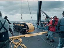
Recovery of the deep-tow sidescan sonar instrument. Click image for larger view.
A deep-towed sidescan sonar was the second leased system used from the Auriga. We anticipated that this system would provide important information about the texture of the sea floor and would locate rock outcrops, faults, methane seeps, and other targets of interest for further exploration with the ROV ROPOS.
The Auriga cruise began May 31 in Seattle and ended on June 13. Six personnel from NOAA and Oregon State University and six personnel hired to operate the sonar and sidescan systems were on board together with seven Auriga personnel. During that time, we completed a multibeam survey that revealed amazing new details about the structure of the canyon. Extremely steep (in some places, vertical) cliffs were found on the south wall of the upper canyon. The new map shows a possible fault extending along this wall and into the lower canyon. The sidescan sonar system showed rock outcrops with fish swimming above them, rock walls with large fractures penetrating them. and mysterious blocks embedded in the soft sediment of the canyon floor.
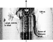
Sidescan sonar "image" of the base of Astoria Canyon wall showing large fractures in rocks. Shadowed areas are pure white. Click image for larger view.
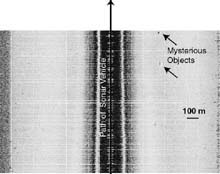
Sonar "image" of mysterious objects on the floor of the canyon at 1,000 m depth. Click image for a larger view and more information about the image.
Sign up for the Ocean Explorer E-mail Update List.