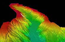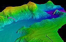
Looking down Astoria Canyon to the southwest . The ROPOS dive tracks of June 29 (fuschia) and July 3 (yellow) are shown. Click image for larger view.
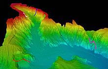
The head of Astoria Canyon, looking east. ROPOS dive tracks are shown for June 28 (blue), June 30 (green), and July 1 (white). Click image for larger view.
Looking east from mid-canyon. ROPOS dive tracks are superimposed in various colors. Click image for a larger view and for more information about the dive tracks.
Visiting the Frontier: Diving into Astoria Canyon, (Phase 2 of the Expedition)
June 26 – July 3, 2001
After seven days of exploration with modern technology, scientists are now able to portray many of upper Astoria Canyon's major geological and ecological features (see summary below). Also of great interest are the keen observations from Richard Hill, the award-winning science writer from The Oregonian. Read his vivid account.![]() View a video of Astoria Canyon Exploration(QuickTime, 2.6MB). Requires QuickTime
View a video of Astoria Canyon Exploration(QuickTime, 2.6MB). Requires QuickTime ![]() .
.
Waldo Wakefield and Robert Embley
Co-chief Scientists
Lewis and Clark Legacy Ocean Expedition
Almost 200 years ago, Meriwether Lewis and William Clark and the Corps of Discovery made their historic crossing of the United States. The Europeans' first exploration of the American West was marked not only by its bold thrust into the unknown, but also by its scientific return. Descriptions of hundreds of plants and animals that were previously unknown to science were a lasting legacy of the expedition. One area of the North American continental platform was inaccessible to early 19th Century explorers, however; it was the continental shelf and slope beneath the Pacific Ocean. During the spring and summer of 2001, an interdisciplinary consortia of scientists, led by investigators from the National Oceanic and Atmospheric Administration, conducted a 7-day mission off the Oregon coast that focused on Astoria Canyon, a major submarine canyon off the mouth of the Columbia River. This modern-day "Corp of Discovery" mapped, explored, and documented the physical, chemical, and biological systems of this westernmost portion of the Columbia River drainage system, which begins just 10 mi west of the present mouth of the Columbia River. The 2001 expedition was particularly fitting in light of the upcoming bicentennial of the original one, because one of Lewis and Clark’s highest priorities was to explore and map the drainage systems of the western United States. During the low sea-level stands of the glacial periods, the Columbia River drained directly into the canyon. Today, the canyon is a virtually unexplored biological haven. With its roots in Lewis and Clark's Corps of Discovery, the exploration of Astoria Canyon offers an exciting public and educational outreach opportunity.
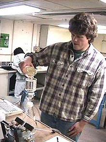
Keith Bosley, of the National Marine Fisheries Service's Rockfish Habitat Group, uses stable-isotope chemical methods to determine food-web relationships between plankton and fish in Astoria Canyon. Click image for larger view.
Using sidescan and multibeam sonars deployed during an earlier cruise in June aboard the vessel Auriga, as well as multi-beam sonar on the NOAA Ship Ronald H. Brown, scientists created new, 3-dimensional, high- resolution images that clearly depict features of Astoria Canyon that have never been observed and documented, such as walls, outcrops, rocks, faults, and slides. The research team also conducted detailed biological, chemical, physical and geological surveys of the canyon using a variety of remote sensing and sampling devices, including a sophisticated remotely operated vehicle (ROV) from Canada, the ROPOS (Remotely Operated Platform for Ocean Science). ROPOS is a powerful, tethered, electro-hydraulic ROV capable of diving to 5,000 m for more than 24 hrs at a time. Deployed from the state-of-the-art research vessel Ron Brown, and able to perform a wide range of functions using an ever-increasing array of sophisticated equipment, ROPOS has provided the scientists of this mission with tools that are critical for viewing and sampling both the sea floor and the water column. Biological specimens and geological samples that will prove invaluable to museums and universities were also collected.
Conducting ocean exploration from the Ron Brown with ROPOS provided a special opportunity for teams of geologists, ichthyologists, invertebrate zoologists, physical oceanographers and fisheries biologists to view the sea floor and overlying water column in an interactive, real-time setting. View a clip (2.6MB requires QuickTime) of a ROPOS launch and underwater video. During each 4-hr watch, members representing the various disciplines worked together to guide the track of the ROV through dives that lasted up to 18 hrs. Between and during each ROPOS dive, a separate team of biological oceanographers conducted acoustic transects across the canyon, using a towed Simrad Ek500 echo sounder to search for aggregations of fish and zooplankton. The size fraction of zooplankton and fish imaged during the acoustics survey were ground-truthed with an Isaacs-Kidd mid-water trawl towed from the Ron Brown. A separate group of scientists, aboard the chartered commercial fishing vessel Sea Eagle, conducted sampling with a rope trawl to provide additional validation of the size fraction of larger fishes. Furthermore, samples of multiple trophic levels from the canyon's food web were collected from both the Ron Brown and the Sea Eagle so scientists might better understand the trophic dynamics at work in the canyon after analyzing the data with stable-isotope methods.
CTD (conductivity, temperature, depth) casts that included optical and chemical sensors were conducted to monitor oceanographic conditions throughout the expedition. Data from these casts will define the distribution of dissolved and particulate materials (nutrients and organic matter). To link these distributions to transport processes through the canyon, two moorings were deployed with sensors that monitor current flow and particulate-matter concentrations. These measurements will be used to quantify the oceanographic conditions under which biologically important material is transported and concentrated within the canyon.
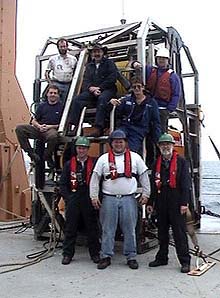
The ROPOS crew (clockwise from center foreground): Keith Tamburri , Keith Shepherd, Sebastian Durand, Mike Dempsey, Craig Elder, Ian Murdock, Kim Wallace, Bob Holland. Click image for a larger view.
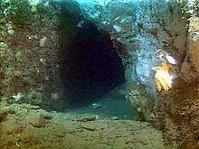
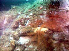
The information obtained from the remote mapping exercise, directly from the ROPOS dives, and from the array of other sampling methods, have produced views of complex habitats determined by the submarine canyon's geologic history. One of the major influences on fish and invertebrate habitats is the history of erosion and mass wasting revealed on the canyon walls. A dramatic example of this was found on the north wall of the upper canyon, where the tops of large slump blocks formed a jumbled mosaic that hosted an array of invertebrates, but a surprisingly low number and low diversity of bottom-dwelling fishes. In contrast, at depths of 500-1,000 m, the canyon floor was characterized by high levels of particulate matter raining down onto a soft-sediment sea floor. The surface was composed of soft, loose sediments, punctuated by burrows and mounds made by a variety of animals, indicating both high levels of nutrients and high densities of infaunal invertebrates. The invertebrate and fish epifauna was dominated by sea cucumbers, sea stars and several deep-dwelling fishes, including the commercially valuable "slope complex" of thornyheads, Dover sole, and sablefish.
On the final and deepest dive of the expedition, at a depth of more than 1,300 m in the canyon axis, the exploration revealed a steep wall rising 400 m from the canyon floor. A lush community of deep-water invertebrates, including numerous species of gorgonian and black corals, was discovered inhabiting this wall. It is not known why this highly diverse community was found in this portion of the canyon province. With all of the information collected over the course of the exploration, however, scientists will have the opportunity to answer questions regarding the distribution of the corals, and, more generally, how the structure of the canyon and the currents interact to influence the distribution and abundance of biological life.
Sign up for the Ocean Explorer E-mail Update List.


