


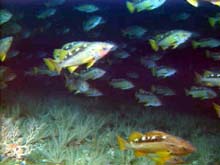
A large school of yellowtail rockfish parades over the sea floor, which is covered with crinoids and a basketstar (lower left). Click image for larger view.

ROPOS grabs a rock and crinoid sample. Click image for larger view.
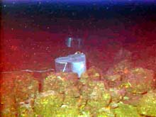
Juvenile rockfish traps were placed on the sea floor during Dive R605 at a depth of 75 m. Schools of juveniles are often spotted on Heceta Bank, but they are hard to capture and study. Click image for larger view.
Traps and Transects: Fish Studies on Heceta Bank
July 6, 2001
Susan Merle, Geological Research Assistant
Cooperative Institute for Marine Resource Studies Program, Oregon State University
Vents Program, Pacific Marine Environmental Laboratory, NOAA
and
Curt Whitmire
Cooperative Institute for Marine Resource
Studies
Oregon State University
After a day of inclement weather, the remotely operated vehicle (ROV) ROPOS went back in the water on July 5 at 12:28 pm PDT. Dive R605 began with the deployment of three fish traps, with the goal of catching juvenile rockfish to find out where their nurseries are located. By comparing data about the locations of juveniles and adults, we may be able to ascertain if the juveniles remain in the area when they mature, or migrate elsewhere. These data will hopefully assist in management decisions for various species of rockfish. Steve Parker, of the Oregon Department of Fish and Wildlife, will also be taking fin tissue samples from the juveniles to conduct studies on population genetics. In addition, blood samples will be collected for basic blood chemistry and physiological analyses.
ROPOS ran a series of fish transects over the same track visited last year at station 3, located on the southern high portion of Heceta Bank in water depths ranging from 70 to 130 me. The purpose of the transects is to quantitatively associate fish densities with bottom types. This is a new method of conducting stock assessments and also provides valuable information on fish habitat associations. When these data are compared with historical data, fish abundances in the late 1980s and can be compared to the present.
By evening, winds were again blowing around 25 knots, making deployment and recovery operations too dangerous to continue. ROPOS was pulled out of the water at 8:39 pm PDT, ending dive R605.
Night operations switched over to more bioacoustic profiles and acoustic doppler current profiler (ADCP) transects. Last night’s transects were run from west to east on the south central portion of the bank, and, combined with the transects from the previous night, will map the entire current structure of the southwest portion of Heceta Bank.
ROPOS returned to the water this morning at 6:15 am PDT for Dive R606 at historical station 2 on the west central portion of the bank. A major objective of this dive was again to conduct fish transects. We also had time, however, to survey an area on the sea floor that Bob Embley (co-chief scientist of this expedition) and Chris Goldfinger (a marine geologist at Oregon State University) believe is the sight of an ancient shoreline. Dive R606 ended around 4:20 pm PDT.
Tonight, the ship is heading over to the area where the fish traps were deployed. It is hoped that tomorrow will bring good news about what we caught!
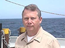
Captain Dreves aboard the NOAA Ship Ron Brown.
A rosethorn rockfish (foreground) is dwarfed by the rock ridge at a depth of 75 m. Crinoids often blanket these rocky outcrops. Click image for larger view.

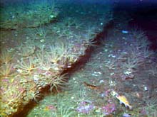
Three basketstars (light pink) and many crinoids perch upon a large boulder near historical station 2 at a depth of 113 m. Rocky ridges and large boulders seem to be the preferred habitat for basketstars. Click image for larger view.
A Profile of Captain Donald A. Dreves Commanding Officer
NOAA Ship Ronald H. Brown
One of the people making our summer cruises possible is Capt. Don Dreves. He has been the commanding officer of the Ronald H. Brown for about six months now, and is no stranger to sea life. Growing up on Long Island, NY, Capt. Dreves spent a lot of time on or near the water. During high school, his interest in the sea progressed into feelings about his potential career. "In the early 1960s, oceanography was something that people were just starting to become interested in as an area of research. When I got out of high school, I thought that might be an interesting career to pursue," he says. Capt. Dreves' career pursuits began at the New York Maritime College at Fort Schuyler, where his undergraduate work included a major in physical oceanography and minors in meteorology and marine transportation. It was there that he began his excursions at sea. While training to get his mate's license, he spent his summer vacations on a training ship, which prepared him for a career on the water.
After college, he became a deck officer in the U.S. Merchant Marines, but a growing family brought him back to land, where he worked in a number of jobs, including selling fruits and vegetables for a supermarket chain, working for at publishing company as a ghostwriter for Jacques Cousteau, and a stint as a port captain for a steamship agency in New York City. He felt that something was missing, however. His interest in marine life rekindled his pursuit of a career that included time at sea. He was five years out of college when he interviewed for the NOAA Corps and began his NOAA career working as a junior officer on a hydrographic survey ship.
Capt. Dreves' career included an assignment at NOAA's Pacific Marine Environmental Laboratory (PMEL), where he was a research assistant in a group known as COER, for Coastal Oceanography and Estuarine Research. Spawned by the construction of the oil pipeline in Alaska, the group conducted oceanographic research in the Gulf of Alaska for the Outer Continental Shelf Environmental Assessment Program (OCSEAP). Other positions the captain has held include operations officer and executive officer aboard NOAA ships, commanding officer of the NOAA Officer Training Center, manager of the national PORTS (Physical Oceanographic Real Time System) program, hydrographic program liaison for NOAA's Pacific Marine Center, Chief of Planning and Management for the Director of the Coastal Geodetic Survey, and a position in the Special Projects Office of NOAA's National Environmental Satellite Data and Information Service (NESDIS), where he was on detail to the intelligence community for 4-1/2 yrs.
Capt. Dreves' sea career has taken him all over. He has performed hydrographic survey work on the U.S. East Coast and in the Gulf of Mexico, in Alaskan waters and the Canadian Arctic. He assisted in marine mammal surveys in the eastern tropical Pacific, and conducted environmental assessments in the Gulf of Alaska. Recently, a research cruise took him and the Ron Brown to the Sea of Japan. He has also spent a considerable part of his professional life on land, but his education and training seem to be fitting for a career on the water. When asked why he continues to come out time and again, Capt. Dreves simply proclaims, "I love to be at sea."
Sign up for the Ocean Explorer E-mail Update List.