


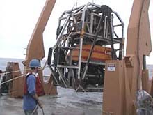
Readying ROPOS for its first dive. The dive took place on the south wall of Astoria Canyon. Click image for larger view.
The First Exploration of Astoria Canyon
June 28, 2001
Jeff Goodrich, Teacher-at-sea
Earth Science Teacher
Lake Oswego High School
Lake Oswego Oregon.
and
Susan Merle, Geological Research Assistant
CIMRS Program, Oregon State University
Vents Program, Pacific Marine Environmental Laboratory, NOAA
The swells have died down and we currently have clear blue skies from a high-pressure system that moved in. This morning we deployed the remotely operated vehicle (ROV) ROPOS, which arrived on the ocean floor at a depth of 597 m (1,958 ft) in the upper part of the canyon. It explored, recorded, sampled, and probed all day along the south canyon wall. The dive began at the base of the wall where the sea floor is quite hummocky and covered with a thick layer of sediment that is easily stirred up as brown clouds that impair visibility. This particularly muddy bottom confirms stories from local Astoria fishermen who report their bottom trawl gear as "mudding down" in this area. The ROPOS team must be careful to keep the clouds to a minimum.
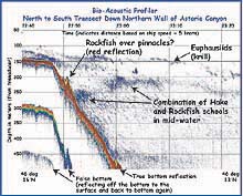
Data from the bioacoustic profiler on the first day of the expedition. Note the steep canyon walls beginning at 150 m depth. Click image for larger view.
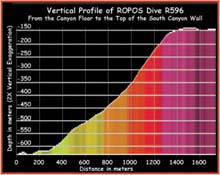
The first ROPOS dive at Astoria Canyon (R596) started at the canyon floor and made its way up the southern canyon wall. The image is a vertical profile of the dive track, based on data collected on the M/V Auriga a couple weeks prior to the cruise on the NOAA research vessel Ron Brown. Click image for larger view.
The beauty of an ROV is that a geologist, ichthyologist, invertebrate zoologist and physical oceanographer can all see the bottom at the same time. Expertise in each of these areas allows for the sharing of ideas between the scientists as the action is happening. Navigating ROPOS up through the canyon is no easy task. The mapping cruise, completed two weeks ago, provided detailed maps that are essential for bottom work with the ROV.
The head of the Astoria Canyon is a rich habitat for a diverse array of fishes and invertebrates. The ROPOS control room monitors show that the canyon abounds with life. Scientists gather around them and enthusiastically yell out the scientific names of organisms. Sprinkled over the bottom are colorful creatures that stand out on the brownish-yellow mud. Sea cucumbers, starfish, jellys, sablefish (also known as black cod), thornyheads, eel-pouts, and schools of shrimp are seen repeatedly. As soon as the ROV started climbing up the canyon wall, the habitat changed. With rock outcrops on the upper, steeper wall, came a change in species composition. Suspension feeders, such as crinoids, sponges, and polycheate worms, dominated on the wall. As ROV exploration continues, unusual species are continually appearing. A gravelly bottom may yield yet another habitat change.
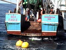
The commercial fishing vessel Sea Eagle will support water chemistry and current studies during the cruise, and will also trawl the mid-water depths for fishes and invertebrates. Click image for larger view.
At 5 pm, we met the 85-ft commercial fishing vessel Sea Eagle to pick up four 28-in-wide steel buoys for Ed Baker's water chemistry and current studies (read an interview with Dr. Baker, principal investigator of the expedition, below). His instruments, along with the buoys, are sunk and tethered to the bottom with weighted railroad car wheels. In a month, an acoustic release will allow the instruments to rise to the surface, where they will be collected on another cruise. We picked up the buoys with a small boat in calm conditions. The fishing vessel will also be doing a mid-water trawl for us to sample pelagic community populations. The Sea Eagle is skippered by Capt. Danny Parker, a local Astoria fisherman, who will be working with the NOAA Ship Ronald Brown on July 1-2 to ground truth the bioacoustics studies with a large rope trawl.
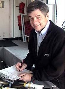
Ed Baker, a supervisory oceanographer at NOAA's Pacific Marine Environmental Laboratory and principal investigator of the Lewis and Clark Legacy expedition, prepares to deploy moorings that will measure ocean currents, temperature and particulate content.
Interview with Dr. Ed Baker
Principal Investigator, Lewis and Clark Legacy
Supervisory Oceanographer
NOAA, Pacific Marine Environmental Laboratory
Ocean Explorer Team: What type of oceanographic research do you do?
Dr. Baker: I'm a physical oceanographer who was originally trained as a geologist. I've done a lot of projects in the deep sea looking at manganese nodules. I've also worked on submarine canyons, looking at the transport of sediment off the shelf through the canyons to the deep sea. Currently, I'm working on hydrothermal vents and how plume material gets distributed throughout the ocean, how heat fluxes out of the sea floor, and the relationship of geology to the proximity of hydrothermal vents.
Ocean Explorer Team: What are you looking for at Astoria Canyon?
Dr. Baker: We're here to supply the physical background information on the circulation and distribution of nutrients and particulate matter in the canyon. Our research involves putting in current meters and doing CTD (conductivity, temperature, and depth) work to measure the hydrography, temperature, salinity, distribution of particles, and methane in the water column. Our focus is concentrating on the flow of water in the canyon and how it is affected by longshore currents. These currents, which flow parallel to the shore, have a large influence on how water is circulated within the canyon itself, and this, in turn, influences the upwelling and downwelling of nutrients. Overall, we're trying to get a physical picture of what the canyon looks like.
Ocean Explorer Team: Do methane seeps exist on the bottom of the canyon?
Dr. Baker: They may well exist there. Methane seeps are known to be present further out on the slope because of the Cascadia Subduction Zone, where the tectonic plate known as the Juan de Fuca Plate descends under the North American Plate. The sediments get all "crinkled up," which forces the methane cold seeps to the surface. A lot of work has been done on methane seeps and methane hydrates further offshore. We're going to look for the same thing in the canyon, because seeps may be influencing the deep-water biological activity and macrohabitats.
Ocean Explorer Team: In your opinion, what is the most exciting part of the Ocean Exploration Program to Astoria Canyon?
Dr. Baker: This is very different from regular oceanographic research, and the exciting part is that you have the opportunity to find things that you weren't expecting to find. The opportunity to do something that is not constrained by a particular program is probably the biggest advantage. You can let your imagination get carried away. I'm excited about helping out the biology crew. I think it's a very bold step by the government and NOAA to let people do this sort of thing.
Sign up for the Ocean Explorer E-mail Update List.