


This mussel shell and other shell material were collected from a sand/silt bottom, at the base of an ancient headland. The samples will be analyzed to determine if they date back to a time when the sea level was much lower, during the last Ice Age (about 17,000 yrs ago). Click image for larger view.
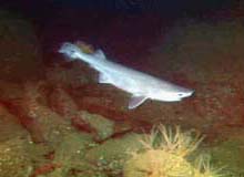
During Dive R610, at 150 m depth, this unidentified shark glided in front of the ROV camera. This was the first shark observed during the Lewis and Clark Legacy Expedition to Astoria Canyon and Heceta Bank. Click image for larger view.
The rugged topography (220m) observed on dive R610 provides essential habitat for a variety of invertebrates, including the vase sponge (left foreground) and crinoids captured in this image. Click image for larger view.
Ancient Headland and Shoreline
July 9, 2001
Susan Merle, Geological Research Assistant
Cooperative Institute for Marine Resource Studies Program, Oregon State University
Vents Program, Pacific Marine Environmental Laboratory, NOAA
and
Curt Whitmire
Cooperative Institute for Marine Resource
Studies
Oregon State University
Around 10 am PDT on July 8, the remotely operated vehicle (ROV) ROPOS returned to the water for Dive R610 and descended toward the sea floor for another series of fish transects, this time near historical station 4. This area of Heceta Bank is characterized by topography of high vertical relief. The ROV glided over massive outcrop ridges and fields of large boulders, illuminating habitats suited for diverse assemblages of fish and invertebrates. Many rockfish species were observed taking refuge in the nooks and crevices of this terrain. The ROV lights illuminated "forests" of crinoids that shared ridges with seastars, brittlestars, nudibranchs, and numerous species of sponges. We took samples of a couple of these sponges, along with two crinoids, a brittlestar, and a nudibranch. At one point, the entire control room was startled by the sight of a shark gliding into the camera's view. We followed it for a while, but were unable to determine its genus. Despite many interesting segments, the fish transects of R610 were cut short due to the onset of dusk. Fish behavior has been known to drastically change during this transition from day into night, known as the crepuscular period. When we began to notice a decrease in the number of fish over the same types of habitats, ROPOS was winched from the bottom and back on deck by 8:52 pm PDT.
While heading to our next ROV dive location, we conducted more transects with the bioacoustic profiler. With this data, we hope to provide information about the locations of various aggregations of fish and pelagic invertebrates.
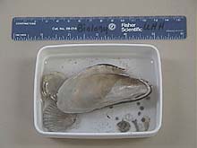
At 1:06 am PDT on July 9, ROPOS entered the water for its nightly geological surveys. Beginning Dive R611, the ROV touched down on a silt bottom near a large promontory west of the northern shallow portion of the bank. Bob Embley, a marine geologist with the Pacific Marine Environmental Laboratory, believes this area is an ancient headland. A major portion of the dive was spent searching for evidence, such as sand and shell fragments, which, when dated, may reveal a time period when the shoreline of present-day Oregon was considerably seaward. An intact mussel shell was collected, and since mussels are intertidal species, the shell could be an important find.
The ROV then proceeded over the top of this headland. Patches of silt were dispersed between large ridges. As in Dive R610, these ridges supported many crinoids, sponges, and other invertebrates, and offered refuge for countless rockfish, mostly sharpchins. Hagfish and cottids seemed to prefer the silt flats between ridges. One of the highlights of the dive occurred when Keith Tamburri of the ROPOS crew snared a cusk eel with the ROV's robotic claw, which had half-buried itself in the mud. Tissue samples were taken from the eel in order to learn more about its physiology and population genetics. Dive R611 ended around 8:30 am PDT on July 9, so we could transit over to our next dive location. We conducted a short "bounce" dive for the purpose of gathering the juvenile rockfish traps that were deployed on July 5. Unfortunately, no fish were in the traps, but we did collect a number of shrimp and a hermit crab.
Around 1 pm PDT on July 9, ROPOS was back in the water, heading toward the bottom south of historical station 3. More fish transects are scheduled for this location, on the shallow top portion of the southern bank, which has never been visited on historical transects or with the ROV. There is much anticipation as to what new discoveries we will find!
Sign up for the Ocean Explorer E-mail Update List.