

Synthetic Aperture Sonar (SAS)
Synthetic aperture sonar (SAS) is an emerging type of sonar that uses an artificial, or synthetic, array to capture high-resolution images. SAS can be used for imaging cultural heritage sites like shipwrecks, classifying habitat or biological organisms, and characterizing seafloor sediment makeup.

SAS scan of an unidentified shipwreck off of the coast of Nantucket. Image courtesy of ThayerMahan, Inc., Kraken Robotics, and the NOAA Office of Ocean Exploration and Research. Download largest version (jpg, 7.8 MB).
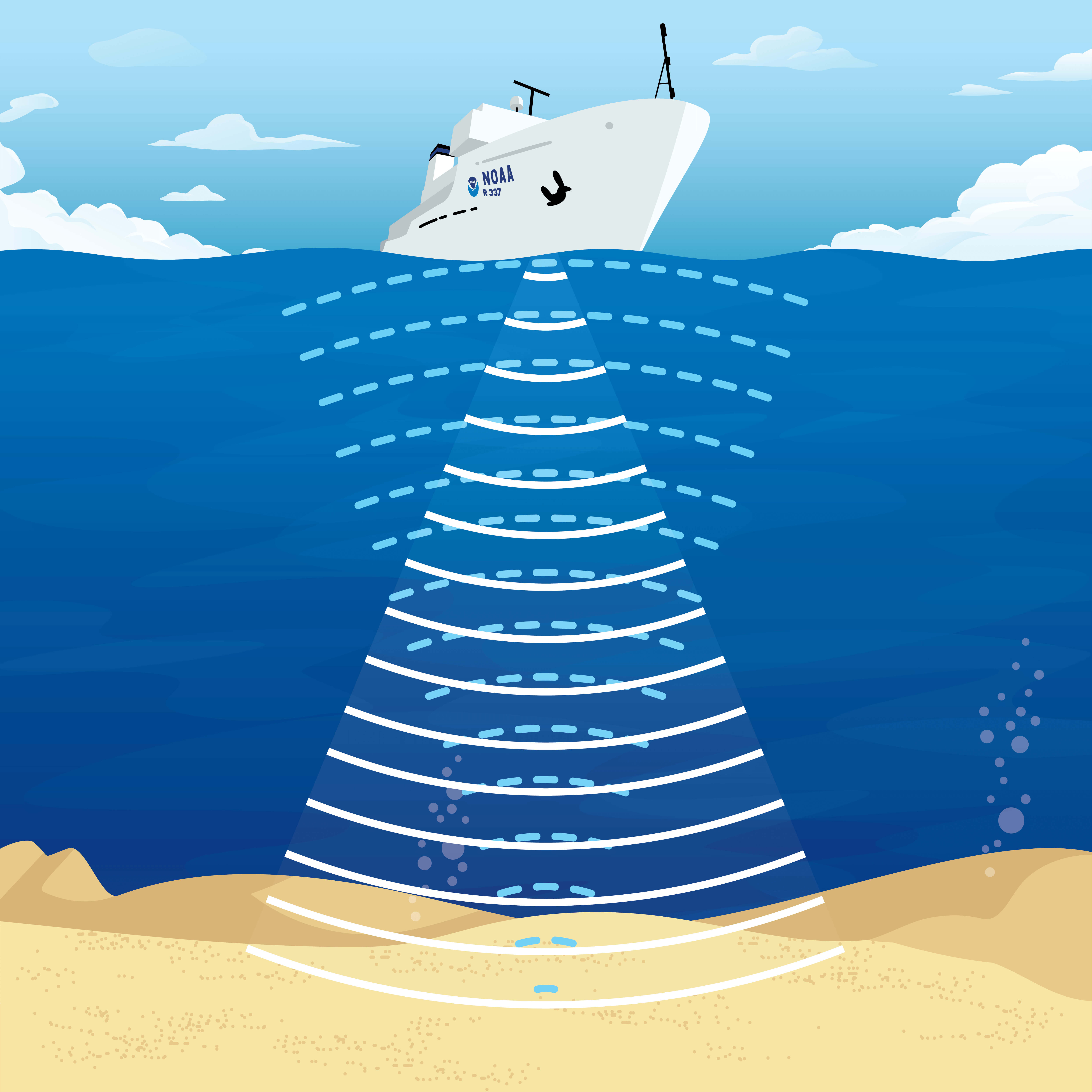
SONAR, short for SOund NAvigation and Ranging, is a tool that uses sound waves to explore the ocean. Scientists primarily use sonar to develop nautical charts, located underwater hazards to navigation, search for and identify objects in the water column or seafloor such as archaeology sites, and to map the seafloor itself. With a sonar survey, a platform is equipped with a group of physical sensors, called a transducer array. This array emits an acoustic signal or pulse of sound into the water. If an object is in the path of the sound pulse, it bounces off the object and returns an “echo” to the array. The array can then measure the strength of the signal. By determining the time between the emission of the sound pulse and its reception, the range and orientation of the object can be determined.
How does it work?
With traditional side scan sonar, the resolution or quality of the image decreases with distance from the transducer array. Similar to a camera, a larger lens is needed to capture far away subjects in great detail. Ideally, a larger array would improve the image quality of the sonar, but the average 3.5 to 4.5-meter (12 to 15-foot) AUV cannot handle the size of such an array. This is why scientists have created an artificial array that increases resolution without changing the physical size of the transducers.
With a traditional sonar system like side scan, the transducer array sends out an acoustic pulse and waits for it to return before sending out another one. Synthetic aperture sonar instead sends out continuous pulses without processing these returns, allowing it to artificially extend the array by combining the returned signals. reach by receiving multiple measurements of a single location at once. A SAS beam is like a “funnel” that overlaps with itself multiple times to achieve highly detailed images. As a result, synthetic aperture sonar can map a site at 30 times the resolution of traditional side scan sonar.

With side scan sonar (left), each pulse measures a distinct, separate area of the seafloor. In contrast, the pulses of synthetic aperture sonar (right) overlap with each other and measure each area more than once. This artificially lengthens the reach of the array. Image courtesy of NOAA. Download largest version (jpg, 135 KB).
Advantages/disadvantages
One reason synthetic aperture sonar is gaining popularity is due to its versatility. SAS is commonly used in archaeological site surveys because of its ability to map in high detail. A SAS image can indicate changes from hard to soft seafloor sediment, as well as show marine habitats on the seafloor such as fish holes or burrows. When combined with depth measurements recorded by multibeam sonar, SAS data can also be used to create detailed maps of the seafloor. It can even be used to scan for mines or underwater listening devices in military operations.

In this synthetic aperture sonar image of the USS Murphy, the gun turrets and tower structure are visible. Image courtesy of ThayerMahan, Inc., Kraken Robotics,and the NOAA Office of Ocean Exploration and Research. Download largest version (jpg, 8.7 MB).
However, synthetic aperture sonar does have some limitations. SAS is expensive to operate and is traditionally considered less efficient than side scan. generally covers less ground than side scan sonar. In order to achieve such high resolution, scientists use equations to map the system’s trajectory. Thus, the system must move in a predetermined direction with respect to the seafloor in order to satisfy the assumptions of the calculations. This can constrict the use of SAS, and scientists may choose to use a more flexible form of sonar depending on the situation.
References
Blomberg, Dr. Ann E. A. “An Introduction to Synthetic Aperture Sonar (SAS).” University of New Hampshire 2014-2015 CCOM/JHC Seminar Series. UNH’s Jere A. Chase Ocean Engineering Laboratory. Feb 6 2015. Recorded lecture. https://vimeo.com/160000771
Roy Edgar Hansen (2011). Introduction to Synthetic Aperture Sonar, Sonar Systems, Prof. Nikolai Kolev (Ed.), ISBN: 978-953-307-345-3, InTech, Available from: http://www.intechopen.com/books/sonar-systems/introduction-to-synthetic-aperture-sonar