This media resources page provides members of the media with information; resources; and broadcast-, print-, and web-quality imagery developed during the Windows to the Deep 2019: Exploration of the Southeastern U.S. Continental Margin expedition.
From May 30 through July 12, 2019, NOAA and partners will conduct a two-part, telepresence-enabled ocean exploration expedition on NOAA Ship Okeanos Explorer to collect critical baseline information about unknown and poorly understood deepwater areas of the southeastern United States, along the coasts of Florida, Georgia, South Carolina, and North Carolina. The first leg of the expedition begins in Key West, Florida, and ends in Port Canaveral, Florida; the second leg goes from Port Canaveral to Norfolk, Virginia.
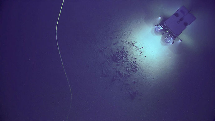
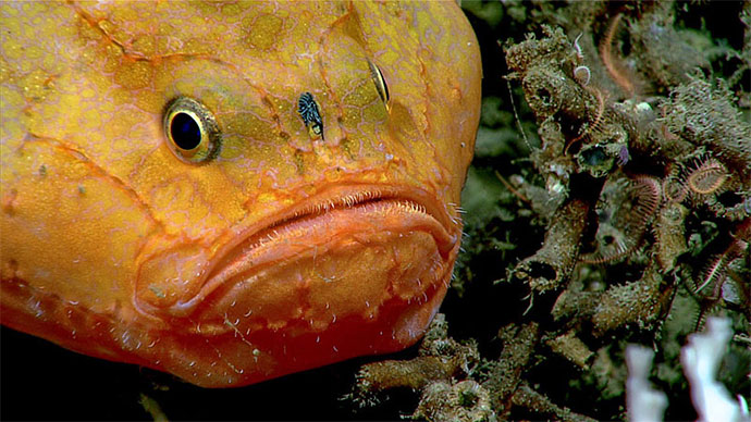
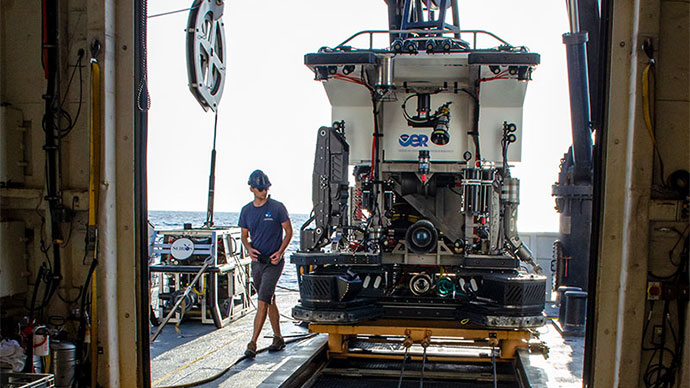
Leg 1 of the expedition, from May 30 - June 14, focused on the collection of seafloor and water column data using the Okeanos Explorer’s advanced mapping systems. Leg 2, from June 21 - July 12, will include both mapping and remotely operated vehicle (ROV) operations, with video from ROV dives streamed in real time daily online from June 21 - July 11. Dive sites are expected to include deep-sea coral and sponge habitats, maritime heritage sites, submarine canyons, and cold seeps.
On this page:
Importance | Objectives | Partners | Who? | Videos & Images | Background Info | Contact Info
Though the U.S. East Coast is home to millions of Americans and is experiencing some of the highest population growth rates in the United States, the southeast U.S. continental margin has some of the largest gaps in high-resolution ocean mapping data on this coast and limited previous observations via submersibles. In fact, the deepwater areas offshore Florida, Georgia, South Carolina, and North Carolina are some of the least explored areas along the U.S. East Coast.
This expedition to explore deepwater areas along the southeastern U.S. coast will fill gaps in our understanding of the region, providing information needed by decision makers to sustain and accelerate the economy, health, and security of our nation. Also, this is the sixth expedition on NOAA Ship Okeanos Explorer to contribute to NOAA’s Atlantic Seafloor Partnership for Integrated Research and Exploration (ASPIRE), a major multi-year, multi-national collaborative ocean exploration field program focused on raising collective knowledge and understanding of the North Atlantic Ocean.
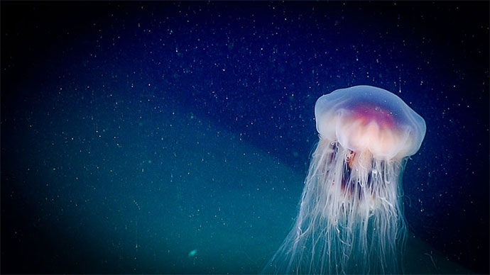
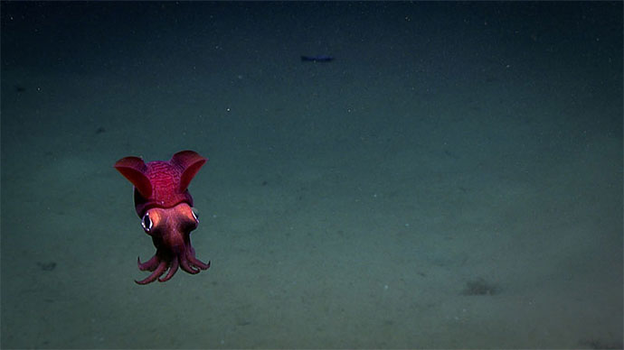
Deep-sea Coral and Sponge Communities: During the expedition, scientists both on the ship and on shore will work to characterize the diversity and extent of coral and sponge communities, which represent some of the most valuable marine ecosystems on the planet, creating structures that provide shelter, food, and nursery habitat to other invertebrates and fish. A better understanding of how populations of coral, sponge, fish, and other deep-sea species are related across geographically separated locales (a concept known as connectivity) can offer insight into the resiliency of those populations and thus is important for predicting the impacts of human activities on coral communities and for developing solid plans for their protection.
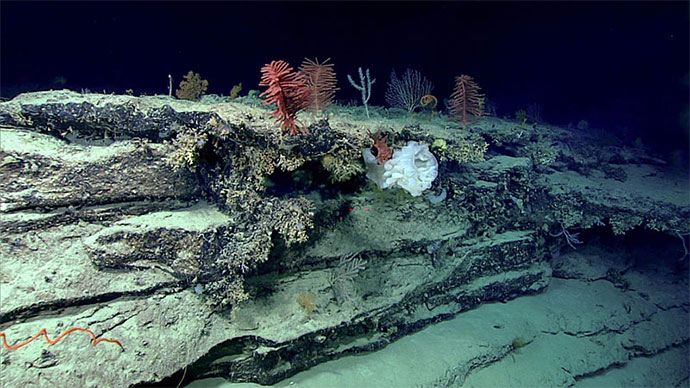
Maritime Heritage: There is perhaps no greater potential for archaeological discoveries in U.S. waters than along the Eastern Seaboard. During Windows to the Deep 2019, scientists will work to identify and investigate sonar anomalies and characterize shipwrecks, offering a rare opportunity to search the seabed for connections to our past, document and preserve history, share that history with the American public, and better understand how these sites are changing over time so we can find ways to protect culturally important historic underwater sites.
Geological History: The team will map, survey, and sample geologic features in order to better understand the geologic context and potential geohazards along the U.S. East Coast. Understanding geological history can lend insights into potential causes and consequences of natural hazards such as submarine landslides and resulting tsunamis along the coast as well as the probability of hazard occurrence.
Leg 2 of the Windows to the Deep 2019 expedition marks the 100th mission during which ocean exploration data has been collected from the Okeanos Explorer, and 2019 marks the 10th year since the first ocean exploration data was collected from the ship. As the NOAA Office of Ocean Exploration and Research leads exploration missions around the globe, data collected during Okeanos missions continues to provide valuable information used to guide or influence decisions in order to maintain a healthy ocean, sustainably manage our marine resources, accelerate our national economy, and build a better appreciation of the value and importance of the ocean in our everyday lives.
The Windows to the Deep 2019 expedition will address science themes and priority areas put forward by scientists and managers from NOAA, management agencies in the region, and the ocean science community. During the expedition, we will work to meet a combination of science, education, outreach, and open data objectives that will support management decisions at multiple levels. These objectives include:
The expedition involves a number of NOAA partners including the Office of Marine and Aviation Operations; the National Marine Fisheries Service’s Office of Habitat Conservation, the Deep Sea Coral and Research and Technology Program, and Southeast Fisheries Science Center; the National Ocean Service’s Office of National Marine Sanctuaries and National Centers for Coastal Ocean Science; the NESDIS National Centers for Environmental Information; and Office of Oceanic and Atmospheric Research's Office of Ocean Exploration and Research. Other partners include the South Atlantic Fisheries Management Council, Bureau of Ocean Energy Management, and the U.S. Geological Survey.
The individuals listed below will primarily lead activities during the expedition. They will coordinate input from multiple scientists and managers participating from shore to plan dives and are several of the voices you hear on the live video feeds and the primary participants in outreach events. For a full list of our on-ship team, please visit this page.

Dr. Amy Wagner has been teaching oceanography, geochemistry, and marine geology at Sacramento State since 2015. Although she grew up in the Arizona desert, she was always drawn to the ocean, is an avid SCUBA diver, and loves being at sea. She earned her undergraduate degree in Marine Science from Texas A&M University, Galveston and her Ph.D. in Oceanography from Texas A&M University, with a focus on paleoceanography and paleoclimate. In Sacramento, she is the founder of the WagsLab (https://wagslab.weebly.com/ ), which provides undergraduate students the opportunity to conduct water isotope research projects. Amy has participated in over a dozen research cruises in all the world’s oceans except the Arctic, including one dive aboard the human operated vehicle Alvin. During the expedition, she will be co-science lead, helping to guide remotely operated vehicle dives, providing narrative regarding the seafloor and the geology, providing commentary on squishy sea critters, and interacting with shore-based scientists.

Alexis Weinnig is a Ph.D. candidate at Temple University in Dr. Erik Cordes’ deep-sea ecology laboratory. Before starting her Ph.D. at Temple University, Alexis completed a M.Sc. in Ecology, Evolution, and Conservation Biology at San Francisco State University and the California Academy of Sciences in 2015. Her first experience with marine research was at Florida Institute of Technology, where she earned a B.Sc. in Biological Oceanography in 2012. Much of her research involves understanding how humans are influencing deep-sea coral communities. To better understand this, she is conducting multiple-stressor experiments, in the laboratory at Temple University, exposing Lophelia pertusa colonies to various levels of pH, temperature, and oil-dispersant mixtures. Assessments of coral health are recorded during and after exposures by examining both the physiological and transcriptomic response of the coral. Alexis has participated in research cruises using submersibles and remotely operated vehicles in the Gulf of Mexico, the Central Pacific, and this will be her third research cruise in the Atlantic Ocean off of the southeastern United States. She is excited to continue exploring and documenting the incredibly diverse and interesting habitats in America’s underwater backyard!

Kasey Cantwell is a Project Coordinator with the NOAA Office of Ocean Exploration and Research (OER). Kasey has a Master of Science degree in Marine Affairs and Policy and Marine Geology and Geophysics and a Bachelor of Science degree in Marine Science and Biology, both from the University of Miami Rosenstiel School of Marine and Atmospheric Science. Kasey is responsible for coordinating telepresence-enabled expeditions conducted onboard NOAA Ship Okeanos Explorer. Since joining OER in 2012, she has coordinated over a dozen expeditions and projects, including multidisciplinary expeditions to the Atlantic submarine canyons, the Marianas, Pacific Remote Islands Marine National Monument, now known as Pacific Islands Heritage Marine National Monument, Glacier Bay National Park, and offshore the southeastern United States.
Beyond deep-sea exploration, Kasey’s background includes imagery-based mapping of coral reefs throughout the Caribbean, long-term ecosystem monitoring, and evaluating resource management strategies to improve efficiency and data quality.

Shannon Hoy is a Mapping Lead with the NOAA Office of Ocean Exploration and Research (OER). She has always had a love of the ocean and pursued a degree in marine biology from the College of Charleston, where she was first introduced to seafloor mapping in 2009. During her undergraduate career, she participated with four seafloor mapping expeditions, allowing her to increase her seafloor mapping knowledge and skills, make valuable connections, and travel to exotic places such as Indonesia and Antarctica. Two of these expeditions were actually aboard NOAA Ship Okeanos Explorer in 2010! After completing her undergraduate degree, Shannon spent the next few years gaining as much multidisciplinary ocean experience as possible. She worked for the U.S. Geological Survey’s Submarine Geohazards Group in Woods Hole, as well as University of Bristol’s Paleoceanography group in the United Kingdom. She continued to map throughout these years, and began specializing in habitat mapping using high-resolution techniques (such as remotely operated vehicle mounted multibeam), seamlessly combining her three disciplines: marine biology, geology, and seafloor mapping. In 2015, Shannon began pursuing her Master’s degree in Ocean Mapping at the University of New Hampshire’s Center for Coastal and Ocean Mapping, with the aim to increase her theoretical acoustic and geodetic background. Towards the end of her graduate degree, she jumped at the opportunity to join the OER team as a Mapping Lead, as being an OER Explorer-in-Training nearly a decade earlier had greatly shaped her career and allowed her to pursue her passion for ocean exploration.
Dive highlight videos, short video clips, and photos will be posted online as they are available.
Please contact Emily Crum for high-res footage, B-roll, and other materials at Emily.Crum@noaa.gov.
Access LIVE video feeds here
Expedition home page
NOAA Office of Ocean Exploration and Research
Emily Crum
Email Address: emily.crum@noaa.gov
NOAA Office of National Marine Sanctuaries
Vernon Smith
National Media Coordinator
Office: (301) 713 - 3125 x248
Email Address: vernon.smith@noaa.gov
NOAA National Marine Fisheries Service
John Ewald
Director of Public Affairs
Office: (301) 427 - 8029
Email Address: john.ewald@noaa.gov
NOAA Office of Marine and Aviation Operations
David Hall
Public Affairs Officer
Office: (301) 713 - 7671
Email Address: david.l.hall@noaa.gov