The essays below will help you to understand the goals and objectives of the mission and provide additional context and information about the places being explored and the science, tools, and technologies being used.
By Kelley Elliott, Martha Nizinski, and Jeffrey Obelcz
.")
From August 10 through September 2, 2018, NOAA and partners will conduct a telepresence-enabled ocean exploration expedition on NOAA Ship Okeanos Explorer to collect critical baseline information of unknown and poorly understood deepwater areas of the Atlantic margin off the U.S. and Canadian east coasts. Like previous expeditions, NOAA will work with the scientific and resource management communities to characterize these areas through telepresence-based exploration.
Read moreBy Jeffrey Obelcz and Martha Nizinski
 view of Hudson Canyon, a shelf-indenting submarine canyon on the U.S. Atlantic Margin offshore New York.")
What’s in a name? For this Okeanos Explorer expedition, the name “Deep Connections” refers to both the U.S.-Canada connections forged and strengthened through the this transboundary expedition and submarine canyons, the “deep connections” between the shallow continental shelf and the deep sea.
Read moreBy Scott C. France and Ellen Kenchington

The oceans can appear to be a homogeneous body of water through which animals can move freely; however, that view is deceptive and we know that marine animals and plants are found in specific habitats and areas and that their distributions can range from whole oceans to specialized locales.
Read moreBy Jeffrey Obelcz and Matt Poti
In a perfect world, scientists would learn about the Earth by sampling everything, everywhere. This is obviously an unrealistic expectation, especially in the ocean where remote sensing methods such as satellites and aerial drones aren’t very useful. As a necessary alternative to oceanographic maps with large blank spaces, scientists use a variety of methods to fill in the blanks. One popular method is probabilistic (also known as predictive) modeling. Predictive modeling is essentially making mathematical “educated guesses” of unsampled locations based on observations, or previously sampled locations, and predictors, which are complementary datasets correlated with observations.
Read moreBy Martha Nizinski
 and Dr. Anna Metaxas shared chief scientist duties during the previous transboundary cruises.")
We often hear the statement that “it takes a village” to describe accomplishments that may not have been realized without a little help from our friends. So too is the case for scientific exploration and discovery. No matter the ocean, country, or province, many of the fundamental questions asked by the worldwide network of marine scientists are similar. Collaborations and partnerships allow us to move forward more quickly to address our goals. All benefit when the community of stakeholders agree to share ideas, resources and data.
Read moreBy the U.S. Fish and Wildlife Service - National Wildlife Refuge System - Northeast Region and NOAA National Marine Fisheries Service - Greater Atlantic Region

On September 15, 2016, President Barack Obama established the Northeast Canyons and Seamounts Marine National Monument by Presidential Proclamation 9496 (81 FR 65159), under the authority of the Antiquities Act of 1906. The Monument is located about 130 miles off the coast of Cape Cod, Massachusetts, and is approximately the size of Connecticut (4,913 square miles). It is the first and only marine national Monument in the Atlantic Ocean. The Monument protects fragile and largely pristine deep-sea environments alive with marine animals. Protecting this unique area as a national Monument will safeguard it for future generations.
Read moreBy Marty King and Ellen Kenchington

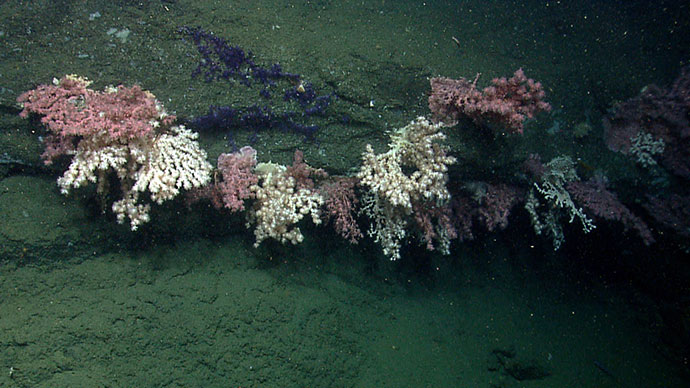
Over the last two decades, Canada has made significant progress in mapping, studying, and protecting cold-water corals in its waters. In 2002, the Northeast Channel Coral Conservation Area was established under the Fisheries Act in an effort to protect a dense concentration of large gorgonian corals from bottom contact fishing. This fisheries closure was the first of its kind in Canada and continues to offer effective protection to what is known as the densest concentration of large gorgonian coral in the waters of the Scotian Shelf.
Read more