by Dr. Martha Nizinski, Biology Science Lead, NOAA Fisheries National Systematics Laboratory
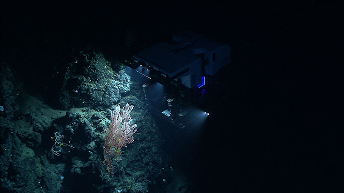
 and Dr. Anna Metaxas shared chief scientist duties during the previous transboundary cruises. Here, each attends to samples collected by the Canadian ROV ROPOS. These samples serve as taxonomic vouchers that further our understanding of the composition, distribution and larval transport of species among canyons.")
Dr. Martha Nizinski (left) and Dr. Anna Metaxas shared chief scientist duties during the previous transboundary cruises. Here, each attends to samples collected by the Canadian remotely operated vehicle ROPOS. These samples serve as taxonomic vouchers that further our understanding of the composition, distribution, and larval transport of species among canyons. Image courtesy of Northern Neighbors: Transboundary Exploration of Deepwater Communities. Download image (jpg, 514 KB).
We often hear the statement that “it takes a village” to describe accomplishments that may not have been realized without a little help from our friends. So too is the case for scientific exploration and discovery. No matter the ocean, country, or province, many of the fundamental questions asked by the worldwide network of marine scientists are similar. Collaborations and partnerships allow us to move forward more quickly to address our goals. All benefit when the community of stakeholders agree to share ideas, resources and data.
Prior to an extensive program of fieldwork dedicated to deep-sea coral habitats and submarine canyons off the Northeast Region (2012-2015), limited deep-sea exploration and research had been conducted recently in U.S. waters of the western Atlantic. The Northeast Region was considered one of the best known areas, given the long history of exploration (dating back to the Challenger expeditions in the 1800s) and commercial fishing. But as the potential increased for fisheries and exploitation of other resources to move offshore, it became apparent that data gaps needed to be addressed.
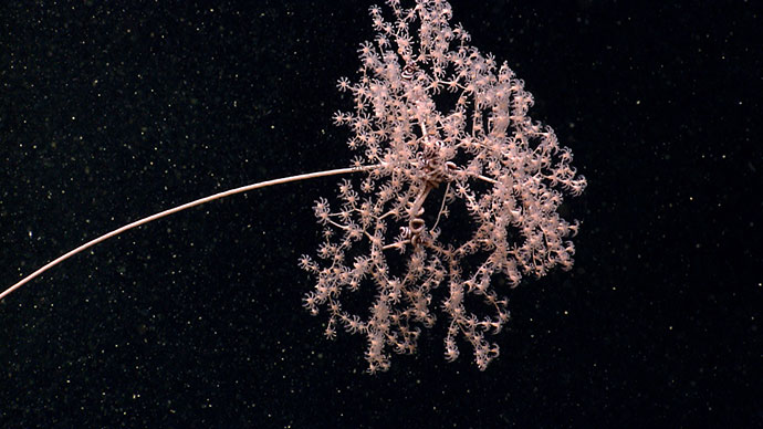
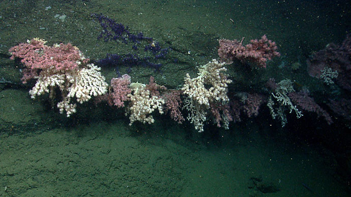
 in U.S waters and Corsair Canyon on the Canadian side of the border. Large aggregations, especially of such large-sized ( > 1 m) colonies, of bubblegum coral in both canyons were amazing findings of this earlier (2014) expedition. Observations such as these contribute to our understanding of distributions and abundances of species, as well as providing clues to the level of population connectivity of organisms among canyons.")
Beautiful coral gardens, dominated by the bubblegum coral Paragorgia arborea, were observed in Heezen Canyon (left) in U.S waters and Corsair Canyon on the Canadian side of the border. Large aggregations, especially of such large-sized (greater than one meter) colonies, of bubblegum coral in both canyons were amazing findings of this earlier (2014) expedition. Observations such as these contribute to our understanding of distributions and abundances of species, as well as providing clues to the level of population connectivity of organisms among canyons. Image courtesy of the 2014 Bigelow-ROPOS US-Canada Gulf of Maine Collaboration. Download image (jpg, 540 KB).
Several management and conservation initiatives were also underway in the region, and resource managers required contemporary data to better inform their decisions. Submarine canyons and deep-sea coral habitats were identified as research priorities by a variety of stakeholders. With the help of technologically advanced sampling gear (towed-camera systems and remotely operated vehicles), we quickly learned that organisms, such as deep-sea corals and sponges, were more diverse, abundant, and widely dispersed than was previously thought.
Living marine resources have no geopolitical boundaries. It is this sentiment that brought together U.S. and Canadian research teams in 2011. Collaborative research needed to be conducted in both U.S. and Canadian waters for us to better understand the patterns we observed and the underlying processes affecting deep-sea corals and sponges.
. Deep Connections 2018 will build on our earlier findings obtained during the 2014 and 2017 expeditions by filling in data gaps through expansion of the areas surveyed and by exploring poorly-known canyons on both sides of the U.S.-Canada border.")
This map shows the cruise track from last year’s transboundary cruise entitled ‘Northern Neighbors.’ Deep Connections 2018 will build on our earlier findings obtained during the 2014 and 2017 expeditions by filling in data gaps through expansion of the areas surveyed and by exploring poorly-known canyons on both sides of the U.S.-Canada border. Image courtesy of Northern Neighbors: Transboundary Exploration of Deepwater Communities. Download image (jpg, 2.5 MB).
Two successful missions (2014, 2017) have been conducted to date. Our primary objective was to explore and survey deep-sea coral habitats in submarine canyons off the coast of the Northeast U.S. and Atlantic Canada, as well as several locations in the northern Gulf of Maine. Scientific teams from each side of the border were selected to enhance our ability to better understand these deep-sea communities. Video; still imagery; physical samples of a variety of invertebrates, including deep-sea corals; sediment cores; water samples; and multibeam bathymetry were all collected and shared amongst the science team.
Through our efforts, we gained a better understanding of coral diversity, abundance, and distribution; tested and ground-truthed habitat suitability models; collected samples for taxonomy, coral aging, and reproduction; refined estimates of coral recruitment; and examined the relationship between biodiversity and ecosystem function.
Additionally, we provided NOAA, the New England Fishery Management Council, and the Department of Fisheries and Oceans Canada (DFO Canada) contemporary data to better inform and guide the conservation of our living marine resources. Data collected during these cruises contributed to the New England Fishery Management Council recommendation to prohibit fishing in waters deeper than 600 meters (1,970 feet) to conserve deep-sea coral habitat, the creation of the Northeast Canyons and Seamounts Marine National Monument, and the creation of the Corsair and Georges Canyons Conservation Area by DFO Canada.
Although we made significant progress, more work is needed. The western Atlantic is not isolated from the eastern Atlantic. Recent research initiatives in Europe and Canada have sparked a renewed interest in transatlantic cooperation. Although these previous transboundary collaborations were under the Atlantic Canyons Undersea Mapping 2012 (ACUMEN) and the Atlantic Seafloor Partnership for Integrated Research and Exploration (ASPIRE) umbrellas, now is an excellent time to open up discussions with additional international colleagues and partners to tie our work more formally to the efforts underway in support of the Galway Statement on Atlantic Ocean Cooperation.
 campaign, a major multi-year, multi-national ocean exploration field program focused on raising collective knowledge and understanding of the North Atlantic Ocean. This maps shows currently identified ASPIRE expeditions (2016-2019). The campaign will provide data to inform and support research planning and management decisions in the region.")
Deep Connections 2018 is the third Okeanos Explorer expedition in 2018 that will contribute to NOAA’s Atlantic Seafloor Partnership for Integrated Research and Exploration (ASPIRE) campaign, a major multi-year, multi-national ocean exploration field program focused on raising collective knowledge and understanding of the North Atlantic Ocean. This maps shows currently identified ASPIRE expeditions (2016-2019). The campaign will provide data to inform and support research planning and management decisions in the region. Image courtesy of the NOAA Office of Ocean Exploration and Research. Download image (jpg, 680 KB).
Discussions with international partners have been productive. Atlantic Ocean Research Alliance (AORA), ATLAS, SponGES, Atlantic Seabed Mapping International Working Group, Department of Fisheries and Oceans Canada, and multiple line offices within NOAA (National Marine Fisheries Service, Office of Oceanic and Atmospheric Research, and National Ocean Service) are all on board for this expedition.
As we increase the extent of the area we will investigate and survey new locations, we will not only add to our knowledge and allow for better assessments of distribution and abundances of transboundary organisms such as deep-sea corals and associated fauna, but these data will also support the vision of AORA for “an Atlantic that is healthy, resilient, safe, productive, understood and treasured so as to promote the well-being, prosperity and security of the present and future generations.”