


2026 Mapping Shakedown
2026 Mapping Shakedown (EX2602) Expedition Plan
NOAA Ocean Exploration’s 2026 field season on NOAA Ship Okeanos Explorer will begin with a mapping shakedown expedition off Hawai‘i from April 29 to May 6, 2026. With a new operational partner, new network systems for both the science team and the ship, and a new look(!), this won’t be your typical shakedown.

Simply, a shakedown is an expedition that tests a ship’s mission systems and equipment before a field season. Conducted annually, these tests simulate typical at-sea operations and are critical for ensuring quality data collection and successful expeditions.


In 2025, the telecommunications system on NOAA Ship Okeanos Explorer was upgraded to take advantage of the higher data speeds and high-definition streaming capabilities offered by a low Earth orbit (LEO) satellite system. Thus, the distinctive satellite dome associated with the previous system was removed from the deck of the ship while in dry dock in early 2026. Seen here, Okeanos Explorer in port in Honolulu, Hawai‘i, in 2024 (left) and 2026 (right). Images courtesy of NOAA Ocean Exploration. Download largest version on the left (jpg, 753 KB). Download largest version on the right (jpg, 932 KB).
Getting to Shakedown
After the 2025 field season ended, Okeanos Explorer went into dry dock in Ketchikan, Alaska. Once out of the water, the ship underwent routine maintenance and repairs to the ship’s critical systems, including hull cleaning and painting, to ensure it can support this year’s science and engineering operations (and look good doing it). To further boost the ship’s deep-ocean exploration capabilities, other off-season activities included installing and testing new equipment, including new split-beam sonar and acoustic Doppler current profiler systems, as well as a new data management system. A new expendable bathythermograph (or XBT) autolauncher designed by NOAA’s Atlantic Oceanographic and Meteorological Laboratory was also added.
Okeanos Explorer is more than just a ship. It’s a mobile, floating communications hub that connects the deep ocean to the rest of the world. The ship and the science team each have their own networks, both newly designed and installed to maximize connectivity and security. These systems are essential for a successful field season. They allow the teams to communicate within the ship, monitor and control the ROVs, and stay connected with shore-based participants and livestream viewers around the world.

The control room is where a lot of the communications take place during an expedition on NOAA Ship Okeanos Explorer. Here, scientists in the back row communicate with folks on shore, and the engineers in the front row communicate with the remotely operated vehicles during the Deep Connections 2019 expedition. Image courtesy of NOAA Ocean Exploration, Deep Connections 2019. Download largest version (jpg, 938 KB).
Welcome Aboard to the OECI
Expeditions on Okeanos Explorer are multipartner affairs. NOAA’s Office of Marine and Aviation Operations owns and manages the ship, which is crewed by officers from the NOAA Commissioned Officer Corps and professional mariners; NOAA Ocean Exploration designs and leads the science operations; and NOAA’s National Centers for Environmental Information manages the data.
For the 2026 season, NOAA Ocean Exploration is partnering with the NOAA Ocean Exploration Cooperative Institute (OECI) to handle critical science operations. The OECI will bring specialized expertise, providing ROV operations and maintenance as well as telepresence and data engineering and video engineering and production.
What’s the OECI?
The NOAA Ocean Exploration Cooperative Institute (OECI) brings together expertise from five partner institutions to support NOAA’s mission in ocean exploration and beyond for the benefit of the scientific community and the public. The OECI partner institutions are the University of Rhode Island, Ocean Exploration Trust, Woods Hole Oceanographic Institution, the University of Southern Mississippi, and the University of New Hampshire.
Let the Shakedown Begin!
Additional planning and preparation for the 2026 field season happened off the ship, during transit to Hawai‘i, and while in port in Honolulu. This shakedown is the first opportunity to begin putting the puzzle pieces together to ensure they work seamlessly together to collect and transmit high-quality data.

Exploration begins with mapping, but the integrity of our maps depends on a system shakedown to verify that our sensors are collecting high-quality data that accurately depict the seafloor. In this image, a mapper works with mapping data in the control room on NOAA Ship Okeanos Explorer during the 2025 Beyond the Blue: Papahānaumokuākea ROV and Mapping expedition. Image courtesy of NOAA Ocean Exploration, Beyond the Blue 2025. Download largest version (jpg, 221 KB).
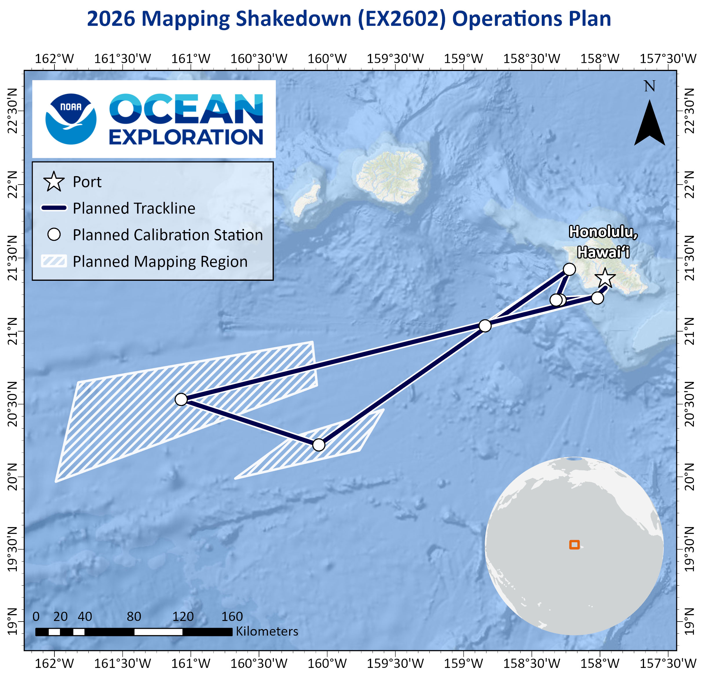
This map shows the area of operations as planned for the 2026 Mapping Shakedown expedition. Map courtesy of NOAA Ocean Exploration, 2026 Mapping Shakedown. Download largest version (jpg, 675 KB).
As a mapping shakedown, this expedition will focus primarily on calibrating and evaluating the performance of the systems used to map the seafloor and water column. In addition to the new systems, there will be many new people on board. Thus, training will be another major part of this expedition.

During the 2026 Mapping Shakedown, the expedition team will also test an upgraded system for measuring conductivity, temperature, and depth (CTD) and collecting water samples. The CTD-rosette system shown here during the 2022 Caribbean Mapping expedition served us well for many years, but the system on board in 2026 features a new frame and a new water sampler, which holds 24 10-liter Niskin bottles, doubling the capacity of the previous system. Another addition to the CTD-rosette system is a photosynthetically active radiation sensor that measures the intensity of sunlight available for plant life at different depths. Image courtesy of NOAA Ocean Exploration, 2022 Caribbean Mapping. Download largest version (jpg, 897 KB).
Once the mapping systems are up and running, the team will begin targeted mapping to fill data gaps in part of the U.S. Exclusive Economic Zone off Oahu.
There’s More Exploration to Come
On the final day of the expedition, the ship will pull into the University of Hawai‘i Marine Center in Honolulu Harbor to load ROVs Deep Discoverer and Seirios onto Okeanos Explorer for their own shakedown expedition. But before returning to sea, the ship will head back to the NOAA Daniel K. Inouye Regional Center on Ford Island in Pearl Harbor, where it will spend the in-port period. This time will be used for final systems integration, refueling, deck training, and more.

Remotely operated vehicles (ROV) Deep Discoverer and Seirios operate as a two-body system off NOAA Ship Okeanos Explorer. To ensure they’re able to livestream video and collect other deep-sea data during the 2026 season, the pair will have their own shakedown in May and June 2026. Seen here on the deck of Okeanos Explorer in the Gulf of Alaska, the ROVs were vital to the success of 2022’s Seascape Alaska expeditions. Image courtesy of NOAA Ocean Exploration, Seascape Alaska. Download largest version (jpg, 734 KB).
Following the ROV shakedown, Okeanos Explorer will be launched into a full season of ROV and mapping expeditions in the central and western Pacific Ocean, concluding with a technology demonstration back in Honolulu.