

NOAA Ocean Exploration in the Field: 2026
NOAA Ocean Exploration works with partners to explore previously unknown areas of our ocean, making discoveries of scientific, economic, and cultural value and supporting innovations in exploration tools and capabilities. In 2026, NOAA Ocean Exploration will lead and support expeditions and fieldwork in the Pacific Ocean, Caribbean Sea, and Lake Michigan.
Read on to learn more about what we have planned for this year and check back often as we add summaries highlighting major accomplishments and other content from each project.
Dates are subject to change.
NOAA Ocean Exploration conducts ocean exploration expeditions on NOAA Ship Okeanos Explorer, the only federal vessel dedicated to exploring our largely unknown ocean for the purpose of discovery and the advancement of knowledge about the deep ocean.
NOAA Ocean Exploration provides support to the NOAA Ocean Exploration Cooperative Institute to explore, map, and characterize the nation’s vast ocean territory, to develop and implement new technologies, and to engage future generations of ocean scientists, engineers, and stakeholders.
NOAA Ocean Exploration manages an ocean exploration competitive grant program to catalyze the ocean exploration community and advance ocean knowledge and collaborates with other NOAA labs and programs to jointly explore the unknown ocean.
NOAA Ocean Exploration provides support for projects as directed by Congress.
This expedition is expected to feature live video of remotely operated vehicle dives via telepresence technology.
Expeditions and fieldwork led or supported by NOAA Ocean Exploration in 2026 are described below; click on a title to expand the text and learn more.
February 23-March 10, 2026 (Second year of fieldwork)
Principal Investigator: Kaustubha Raghukumar, Integral Consulting Inc.
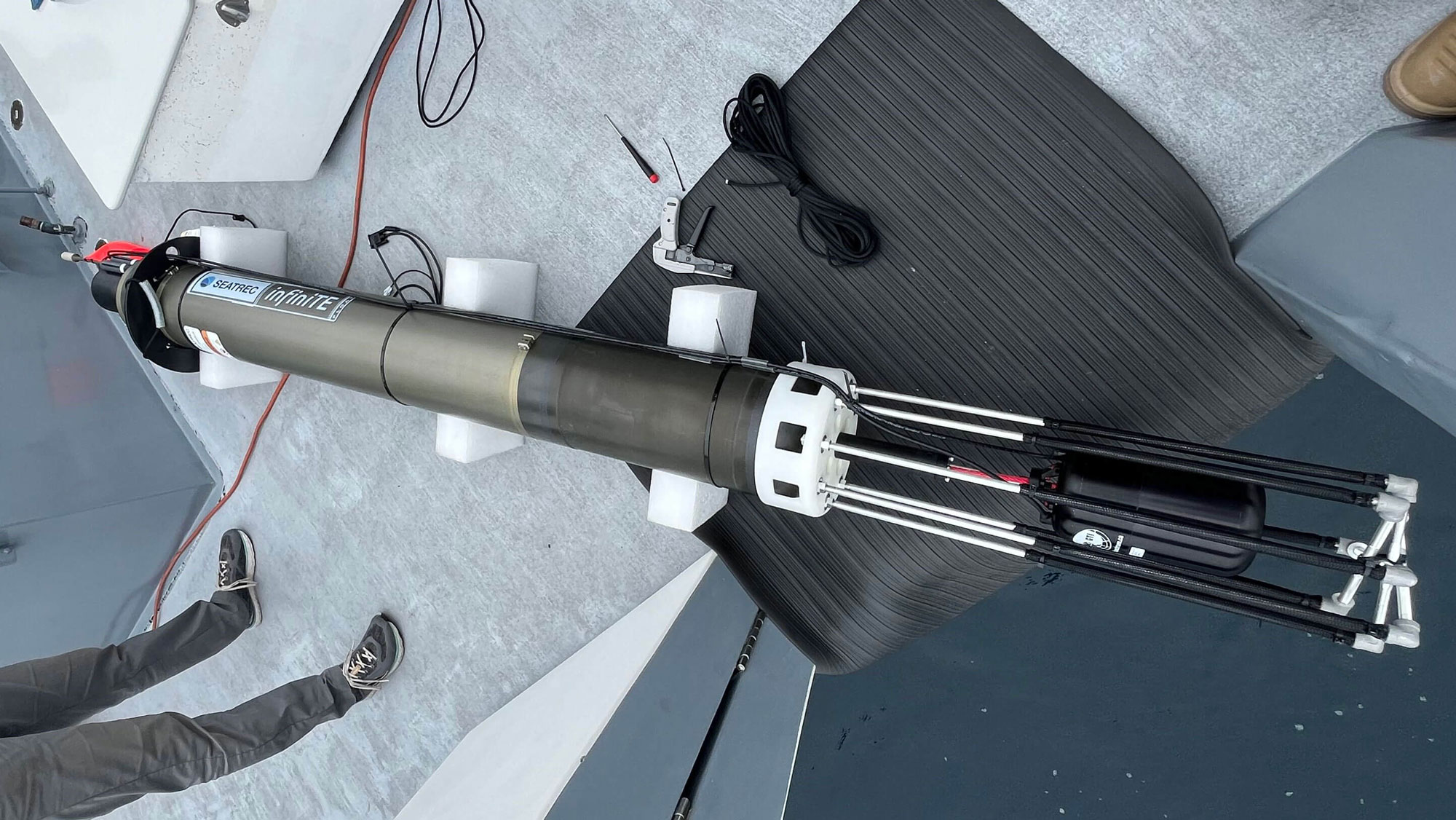
To advance deepwater soundscape exploration, this team of scientists and engineers is developing the first ever autonomous, near-real-time, directional acoustic profiling float powered by marine renewable energy (ocean thermal energy conversion, OTEC). During this second year of fieldwork, they will demonstrate their float during a two-week mission off the coast of Hawai‘i. Also as part of this project, the team will develop soundscape analysis tools to provide insights into acoustic events of interest recorded by the float.
Learn more about this project.
April 29-May 6, 2026
Following a dry-dock period in Ketchikan, Alaska, 2026 field operations on NOAA Ship Okeanos Explorer will begin with an expedition off Hawai‘i to test and integrate the mapping systems used during ship operations. This will include calibrating the ship’s multibeam and split-beam sonars, collecting backscatter normalization data, testing sonar interference and synchronization, and verifying onboard sound speed profiling equipment. These activities are conducted at the start of each field season to ensure acoustic measurements accurately reflect seafloor depth and character — a foundation for the expeditions that follow.
Learn more about this expedition.
May 14-June 6, 2026
Live Video
NOAA Ocean Exploration will lead a remotely operated vehicle (ROV) shakedown expedition off Hawai‘i on NOAA Ship Okeanos Explorer to ensure readiness for the 2026 field season. During this expedition, team members from the NOAA Ocean Exploration Cooperative Institute will conduct rigorous tests to make sure ROVs Deep Discoverer and Seirios are working as expected and that all the systems can effectively communicate with each other. Testing and integration activities will ensure that collected data are of the highest quality. ROV dives will be streamed live online, but the initial focus of the dives will be on engineering, testing, and pilot training and practice. As time and engineering progress allows, we hope to also explore seamounts, deep-sea coral habitats, abyssal habitats, and maritime heritage sites.
Learn more about this expedition.
May 27-June 6, 2026
NOAA Ocean Exploration supports Ocean Exploration Trust’s operations on Exploration Vessel (E/V) Nautilus via the NOAA Ocean Exploration Cooperative Institute to collaboratively advance marine technologies and reduce uncertainties in critical parts of our largely unexplored deep ocean. This shakedown expedition offshore of the main Hawaiian Islands will ensure the ship’s systems are ready for the 2026 field season.
Learn more about the 2026 field season on E/V Nautilus.
June 10-24, 2026
Exploration Vessel (E/V) Nautilus will fill seafloor mapping gaps while transiting between Hawai‘i and Guam to support subsequent expeditions to explore deep-sea habitats offshore of the Mariana Islands. NOAA Ocean Exploration supports expeditions on E/V Nautilus via the NOAA Ocean Exploration Cooperative Institute.
Learn more about this expedition.
June 16-July 9, 2026
After completing shakedown operations off Hawai‘i, NOAA Ship Okeanos Explorer will transit from Honolulu, Hawai‘i, to Rarotonga, Cook Islands. During this transit, the team will use the ship’s suite of sonars to map the seafloor, water column, and sub-seafloor. Targeted mapping; conductivity, temperature, and depth (CTD) profiler deployments; and environmental DNA (eDNA) sampling are planned in the U.S. Exclusive Economic Zone around Jarvis Island.
Learn more about this expedition.
Spring/Summer 2026
Principal Investigator: Mitch Barklage, Illinois State Geological Survey
Understanding the geography and composition of the lakebeds of the Great Lakes is important for a variety of reasons, including the siting of offshore infrastructure, the mapping of sand and other resources, and designing coastal resiliency projects. Detailed mapping of the surface and subsurface of the lakebed is needed for informed management of coastal regions. Still, the Great Lakes remain understudied in this regard as available datasets are sparse/limited. To address data needs, this project team will assess lake-bottom geology and the rock layers of the shallow subsurface of southwestern Lake Michigan along the coast of Chicago, Illinois. They will use sonar technologies to study the layers of sediment and the shape of the solid rock beneath them and integrate the data they collect with existing geological data and data products to create geological maps. The resulting products will contribute to the foundational understanding of Lake Michigan’s geologic history, structure, and composition and guide future exploration, including archaeological investigations of potential pre-contact Native American cultural resources at the bottom of Lake Michigan.

June 28-July 21, 2026
Live Video
Exploration Vessel (E/V) Nautilus will map and explore deep-sea priority areas around the Mariana Islands, one of the most tectonically and volcanically dynamic locations on the planet, focusing on abyssal plain habitats and adjacent seamounts in the southeasternmost portion of the U.S. Exclusive Economic Zone around the Commonwealth of the Northern Mariana Islands. Live video from remotely operated vehicle Hercules will be streamed for public viewing. Autonomous underwater vehicle Sentry will also be used to collect seafloor mapping data and images. NOAA Ocean Exploration supports expeditions on E/V Nautilus via the NOAA Ocean Exploration Cooperative Institute.
Learn more about this expedition.
July 13-28, 2026 (second year of fieldwork)
Principal Investigator: Russ Green, Wisconsin Shipwreck Coast National Marine Sanctuary
This research team will continue their exploration and documentation of a collection of nationally significant shipwrecks in the deep waters (130-480 feet) of Lake Michigan’s Wisconsin Shipwreck Coast National Marine Sanctuary. They will conduct their investigations using a hybrid autonomous underwater vehicle/remotely operated vehicle (AUV/ROV) equipped with acoustic, imaging, and laser scanning sensors, and develop new archaeological methods developed to capitalize on the efficiencies of autonomous and uncrewed vehicles.
Learn more about this project.
July 19-August 13, 2026
Live Video
In July and August 2026, NOAA Ocean Exploration, in partnership with the Cook Islands Seabed Minerals Authority, will conduct a 28-day expedition on NOAA Ship Okeanos Explorer to map and characterize deep seabed habitats in the Cook Islands. Using remotely operated vehicles, mapping technology, and in situ sensors, the team will explore abyssal plain habitats and the Manihiki Plateau, including imaging and sampling the seabed and water column to enable comparisons over a variety of seafloor habitat types. While the expedition is underway, operations will be streamed online in real time; so that shore-based scientists and the public will be able to watch video from dives and hear experts in real time about what they see and learn. Data gathered during the expedition will be made publicly available and shared with the Cook Islands government to support the management of marine resources, including critical minerals, in the region. The work will build on a NOAA-funded 2025 expedition conducted in the Cook Islands on Exploration Vessel Nautilus in partnership with the NOAA Ocean Exploration Cooperative Institute.
Learn more about this expedition.
July 25-August 16, 2026
Live Video
Exploration Vessel (E/V) Nautilus will map and explore deep-sea priority areas around the Mariana Islands, one of the most tectonically and volcanically dynamic locations on the planet, focusing on abyssal plain habitats in the northeasternmost portion of the U.S. Exclusive Economic Zone around the Commonwealth of the Northern Mariana Islands. Live video from remotely operated vehicle Hercules will be streamed for public viewing. Autonomous underwater vehicle Sentry will also be used to collect seafloor mapping data and images. NOAA Ocean Exploration supports expeditions on E/V Nautilus via the NOAA Ocean Exploration Cooperative Institute. On this expedition, the team will also deploy a high-frequency acoustic recording package from the NOAA Pacific Islands Fisheries Science Center to support cetacean monitoring in the region.
Learn more about this expedition.
August 20-September 17, 2026
Live Video
NOAA Ocean Exploration will lead a remotely operated vehicle (ROV) and mapping expedition on NOAA Ship Okeanos Explorer to explore deep waters in and around American Samoa. This expedition will include ROV dives to explore the seafloor and water column, mapping operations, and continuous shoreside participation via telepresence technology. Data from this expedition will help improve our understanding of the geological history and deep-sea habitats of American Samoa and provide critical information for the management of marine resources, including critical minerals, in these waters.

August 20-September 18, 2026
Live Video
Exploration Vessel (E/V) Nautilus will map and explore deep-sea priority areas in the U.S. Exclusive Economic Zone around Wake Island, one of the most isolated land masses on Earth and one of the least explored areas under U.S. jurisdiction. Exploration will focus on science priorities of the Pacific Islands Heritage Marine National Monument and the Wake Atoll National Wildlife Refuge, including abyssal plain habitats, unexplored seamounts, and potential maritime heritage sites associated with the Battle of Wake Island. Live video from remotely operated vehicle Hercules will be streamed for public viewing. NOAA Ocean Exploration supports expeditions on E/V Nautilus via the NOAA Ocean Exploration Cooperative Institute.
Learn more about this expedition.
August/September 2026
Principal Investigator: Richard R. Coleman, University of Miami
Mesophotic (“middle light”) coral ecosystems provide habitat for an array of vulnerable and ecologically and commercially important fish species. At ocean depths between the brightly lit shallows and the dark deep ocean (30-150 meters/98-492 feet) in tropical and subtropical regions, these ecosystems are difficult to access, meaning they’re relatively unexplored, and our knowledge about the fish that inhabit them is limited. Using advanced deep-diving techniques and data collection methods, this research team will explore the mesophotic coral ecosystems off the western coast of Puerto Rico to better understand these ecosystems and how they are used as habitat by their associated fish communities. Technical divers will conduct complementary stereo-video and visual surveys to document fish occurrence, size, and abundance as well as evidence of marine debris, bleaching, disease, and other threats. They’ll also collect samples of select uncommon, rare, and unknown species for further study and water samples for eDNA analysis. The results of this project will inform the conservation and management of Puerto Rico’s mesophotic coral ecosystems and the fish communities they support and serve as a baseline against which to assess future changes.

September 22-October 12, 2026
Live Video
Exploration Vessel (E/V) Nautilus will map and explore deep-sea priority areas in the U.S. Exclusive Economic Zone around the Hawaiian Islands. Exploration will focus on unexplored ridges and seamounts in the eastern portion of Papahānaumokuākea and abyssal plain habitats southwest of the Main Hawaiian Islands. Live video from remotely operated vehicle Hercules will be streamed for public viewing. NOAA Ocean Exploration supports expeditions on E/V Nautilus via the NOAA Ocean Exploration Cooperative Institute. On this expedition, the team will also deploy a recently developed benthic lander and low-light camera system from the University of Hawai‘i to support deep-sea coral monitoring.
Learn more about this expedition.
September 24-October 19, 2026
NOAA Ocean Exploration will lead a mapping expedition on NOAA Ship Okeanos Explorer, beginning in Suva, Fiji, and ending in Honolulu, Hawai‘i. Twenty-four-hour-a-day mapping operations will use the ship’s suite of sonars to map the seafloor, water column, and sub-seafloor, focusing on waters around American Samoa before beginning the transit to Hawai‘i, filling critical gaps in seafloor mapping data along the way.

October 28-November 16, 2026
NOAA Ocean Exploration will conclude 2026 activities on NOAA Ship Okeanos Explorer with a technology demonstration off Hawai‘i and around Johnston Atoll. During the expedition, NOAA Ocean Exploration, the NOAA Ocean Exploration Cooperative Institute, and partners will demonstrate, test, and evaluate emerging and existing technologies, including a long-range autonomous underwater vehicle capable of exploring at significant ocean depths. Technologies will be tested with possible integration into future NOAA operations in mind.

September 2026 (second year of fieldwork)
Principal Investigator: Guangyu Xu, University of Washington
To advance our knowledge about hydrothermal vents, this research team is developing an innovative approach to identifying, locating, and characterizing hydrothermal discharge. They adapted their proven techniques for using multibeam sonar to characterize hydrothermal vents from a stationary platform for use on uncrewed underwater vehicles. After a successful demonstration in 2025, the team will return to sea to further test their new approach.
Learn more about this project.
Last Updated May 18, 2026
Published May 6, 2026