Celebrating 20 Years of NOAA Ocean Exploration
Twenty Years of Advancing Technology
The question that inspires some of the most creative innovation and imagination is not whether or when we will come to understand our ocean’s greatest depths, but how. Continuing our reflection on 20 years of NOAA Ocean Exploration, we’ll take a look back at some of the technology that has been essential — and game changing — in enabling our exploration of the dark and cold depths of the deep sea. The technologies we use to explore the deep today are continually being improved and adapted to better access and understand what was once unreachable. They are a snapshot in time: what is cutting edge today is but a stepping stone to the technology of the future.
America’s Ship for Ocean Exploration: NOAA Ship Okeanos Explorer and Beyond
In 2000, a presidential panel issued Discovering Earth’s Final Frontier: A U.S. Strategy for Ocean Exploration, which contained a timely and compelling call for an “innovative and bold” U.S. ocean exploration program in which “discovery and spirit of challenge are the cornerstones.” As part of this national exploration program, the panel envisioned a flagship dedicated to voyages of discovery that centralized “data collection and outreach technologies on a dedicated platform.” To bring the panel’s vision to life, NOAA commissioned NOAA Ship Okeanos Explorer in 2008 as America’s first civilian agency ship dedicated to ocean exploration. The ship is operated by NOAA Corps officers and civilians as part of NOAA's fleet managed by NOAA's Office of Marine and Aviation Operations.
For over a decade now, NOAA Ocean Exploration has used Okeanos Explorer to collect ocean exploration data that are shared broadly with scientists, decision-makers, and the public alike. Since its first voyage in 2009, the ship has served as a platform to enable NOAA Ocean Exploration to pursue objectives identified in the panel’s report, ranging from expanding our understanding of marine resources, discovering new species, and mapping the seafloor, to testing new technologies and much more. Through the collection of baseline information in never-before-explored areas, NOAA Ocean Exploration-led expeditions aboard Okeanos Explorer further our knowledge while setting the stage for future in-depth exploration and research.
While we have updated the ship and added new technology continuously over the last decade, the future of “America’s ship for ocean exploration” recently took an exciting turn when it was announced that a new, state-of-the-art NOAA oceanographic research vessel, the Discoverer, will replace some of the functionality of Okeanos Explorer in the near future. The myriad activities that take place aboard Okeanos Explorer are only a subset of our office’s efforts to further ocean exploration, which also include cooperative institutes, a grant competition, the National Oceanographic Partnership Program , the Small Business Innovation Research program, and other partnerships with government agencies, academic and philanthropic institutions, and the private sector. However, as our nation’s flagship for voyages of discovery, Okeanos Explorer has become a focal point and a platform for innovative and ever-evolving ocean exploration and collaboration over the years.
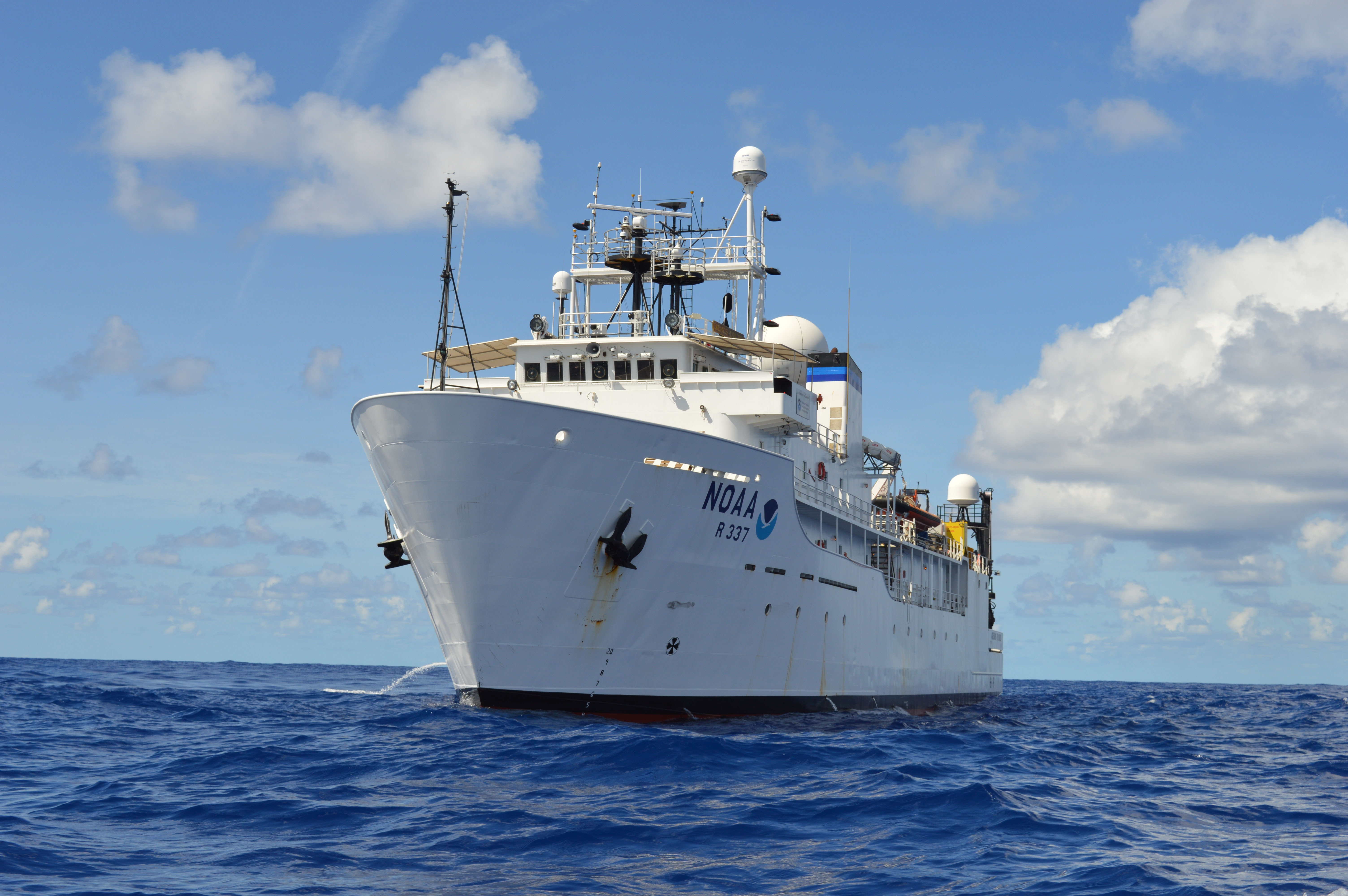
NOAA Ship Okeanos Explorer was first commissioned by NOAA in 2008 to serve as “America’s ship for ocean exploration.” Image courtesy of NOAA Ocean Exploration.
Learn moreSeeing with Sound: Seafloor Mapping
Mapping the seafloor is the first step in exploring our ocean. Early office-supported mapping ranged from evaluating the effectiveness of laser line scan mapping technology for fisheries habitats in 2001, to mapping the Puerto Rico Trench in 2003. In 2008, our inaugural multibeam mapping field trials aboard Okeanos Explorer produced the first publicly accessible modern NOAA multibeam data off the Washington State coast, an area previously restricted by the U.S. Navy. And by 2014, the ship’s EM 302 deepwater multibeam sonar system — the very first of this model in the world — enabled us to reach the milestone of 1,000,000 square kilometers of seafloor mapped using the ship. We used this same technology during the Gulf of Mexico 2011 expedition to successfully test the feasibility of mapping gases in the water column, with the idea that data collected could be used to locate natural seafloor seeps. Since this time, thousands of seeps have been found via various NOAA Ocean Exploration and partner efforts.
In a phased replacement period beginning in 2018 and completed in 2021, the multibeam sonar system was upgraded, making Okeanos Explorer the first ship with a complete and integrated Kongsberg Maritime EM 304 MKII deepwater multibeam sonar system. Kongsberg designed the EM304 to improve the coverage and the quality of the mapping data collected, increasing the efficiency of deep-sea mapping work. We anticipate that the new system will enable us to efficiently map in deeper waters than ever before: 11,000 meters (6.8 miles) versus the 6,000-meter (3.7-mile) depth limit of the ship’s previous multibeam system. As the only federal program dedicated to exploring the ocean, it is imperative for NOAA Ocean Exploration to stay at the forefront of technology, continuously paving the way for others to follow.
Like all NOAA Ocean Exploration data, seafloor mapping data are publicly available. Our current mapping efforts contribute to the Atlantic Seafloor Partnership for Integrated Research and Exploration (ASPIRE) campaign, a multiyear and multinational collaborative effort to map and characterize the deep waters of the Atlantic Ocean; the U.S. National Strategy for Mapping, Exploring, and Characterizing the United States Exclusive Economic Zone, which calls for complete mapping of U.S. waters deeper than 40 meters (131 feet) by 2030; and the international Seabed 2030 initiative, which aims to bring together all available bathymetric data to produce the definitive map of the world ocean floor by 2030.
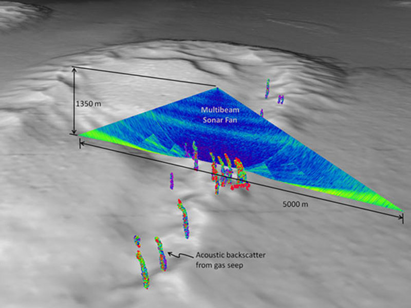
This image from the Gulf of Mexico 2011 expedition shows a view of the multibeam sonar water-column backscatter data used to detect gas seeps. Gas seeps derived from the sonar are shown in the foreground. Image courtesy of the University of New Hampshire Center for Coastal and Ocean Mapping/Joint Hydrographic Center using IVS Fledermaus software.
Learn moreEyes (and More) on the Ground: Underwater Robots
NOAA Ocean Exploration has a long history supporting exploration with submersibles, from the human-occupied submersibles used to explore the Atlantic in 2001 or the volcanoes of the Kermadec Arc in 2005, to remotely operated vehicle (ROV) Little Hercules, which received a major overhaul before exploring Indonesian waters in 2010. We have also supported the testing or development of submersibles, from Woods Hole Oceanographic Institution (WHOI)’s Nereid Under-Ice hybrid remotely operated vehicle, to Boeing’s large autonomous underwater vehicle (AUV), Echo Ranger, meant for exploring fish habitat, to the recent field trials of WHOI’s Orpheus class vehicles.
The office reached an exciting turning point during the 2013 ROV Shakedown and Field Trials in the U.S. Atlantic Canyons with the unveiling of ROV Deep Discoverer, which is capable of diving to depths of 6,000 meters (3.7 miles). This new vehicle gave us access to the vast majority of the seafloor, allowing us to join an elite group that can reach all but the deepest of the world’s ocean trenches. Deep Discoverer, with its cameras, lights, and dexterous manipulator arms for sampling, works in tandem with ROV Seirios, its companion camera and lighting platform, which also absorbs the heave of the ship above, to which it is tethered. We continue to make exciting enhancements to the vehicles to better support science and exploration, from introducing the ability to collect samples in 2015, to the addition of a suction sampler to allow for the sampling and study of more delicate organisms in 2019, to the recent suite of science and navigation instruments added during the 2020/2021 offseason.
The wave of the future for underwater submersibles may be in the form of autonomous underwater vehicles. Automated technology can act as a “force multiplier,” amplifying efforts already underway. One of the current hot topics in the world of hydrography is optimizing the use of autonomous underwater vehicles for mapping. One vision for this would be multiple AUVs equipped with multibeam sonar systems that could be deployed from a larger vessel and used to map concurrently, collecting many times more data than a ship alone could.
Technology testing, like that which occurs during NOAA Ocean Exploration technology demonstrations, is a vital element to pushing the boundaries of ocean exploration technology. During the 2021 Technology Demonstration, Woods Hole Oceanographic Institution’s Orpheus class autonomous underwater vehicles were field tested in conjunction with NASA Jet Propulsion Laboratory navigation system software. Video courtesy of NOAA Ocean Exploration, 2021 Technology Demonstration.
Learn moreExploration for All: Telepresence Technology
Telepresence is the concept of providing an individual or group who is not physically present for an activity (such as remotely operated vehicle dives) with the information they need to participate in the activity in real time. Telepresence technology makes ocean exploration more equitable and accessible and facilitates partnerships between geographically dispersed groups who otherwise might not have the opportunity to collaborate due to cost or logistics. Telepresence has scientific value in terms of increasing the number of scientists who can participate in a given expedition, as well as education and outreach value: this same technology brings real-time exploration into the hands of anyone with an internet connection.
In 2004, we partnered with the National Geographic Channel to give audiences unprecedented access to a telepresence-enabled expedition aboard NOAA Ship Ronald H. Brown, including live views of RMS Titanic more than two miles below the surface of the ocean. Just a year later, a new benchmark in ocean exploration was set when, for the first time, an entire science party participated in an expedition from an exploration command center 4,500 miles away. After being commissioned by NOAA in 2008, NOAA Ship Okeanos Explorer underwent extensive refitting to become the first federal platform customized for systematic, telepresence-enabled ocean exploration. In 2012, we livestreamed an expedition to the public for the first time, significantly expanding our ability to engage would-be explorers around the world. With advances in satellite technology making high-speed internet at sea far more accessible, and remote research becoming more commonplace, the reach and accessibility of telepresence exploration and outreach will only continue to grow.
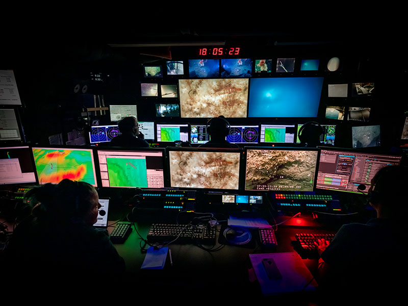
During remotely operated vehicle (ROV) operations, ROVs Deep Discoverer and Seirios are controlled by navigators and pilots, and the exploration is led and narrated by scientists in the mission control room of NOAA Ship Okeanos Explorer, seen here, who watch the video feeds from the ROVs in real time. The same feed is transmitted to shore via telepresence. Image courtesy of NOAA Ocean Exploration, Windows to the Deep 2019.
Learn moreWorth a Thousand Words: Imaging the Deep
While it might seem strange to think of photos, videos, and other imagery as “data,” they are vital to our mission of exploring the deep sea and sharing knowledge with the broader scientific community and public alike. These data can also readily convey the beauty, wonder — and hopefully importance — of a world that few humans will ever see firsthand. Our office has supported the testing or use of many types of imaging technologies over the years, including photogrammetry to build 3D representations from 2D images, the Kraken Robotics SeaVision laser scanner, which uses a line of laser light to generate full color, high-resolution, 3D representations of objects on the seafloor, and the Medusa lander, which uses red light illumination invisible to most deep-sea inhabitants and captured the first-ever footage of a giant squid in its natural environment in 2019.
On Okeanos Explorer expeditions, ROV Seirios has been illuminating the pathway of other ROVs used to collect imagery, principally our ROV Deep Discoverer, since 2011. Like its namesake star, Seirios provides light, as well as an informative view from above, while Deep Discoverer captures imagery with high-definition video cameras and powerful lights that illuminate and image the dark world below. In the spirit of continual advancement, we recently added to Deep Discoverer an upgraded high-definition camera system, an extreme low-light camera, a dimmable LED lighting system, and a BlueView scanning sonar system to detect objects beyond the reach of the ROV’s lights, which together will expand the reach and applications of our video and photo data even further.
Recently, for the first time, NOAA used video alone to designate a new genus and species of organism; a comb jelly observed during a NOAA Ocean Exploration expedition near Puerto Rico. This accomplishment demonstrates that video can be used to identify new species imaged during deep-ocean exploration without the costly and invasive requirement of sample collection. It also highlights the value of telepresence, which allows for real-time discovery no matter where in the world a scientist may be.
In this video, a giant squid, at least 3 - 3.7 meters (10 to 12 feet) in length, approaches the Medusa's e-jelly lure. This is the first footage captured of a giant squid in its natural habitat. Video courtesy of Edie Widder and Nathan Robinson.
Learn moreA Deeper Understanding: Sampling for Science
Since 2015, a limited number of biological and geological samples have been taken during remotely operated vehicle expeditions aboard NOAA Ship Okeanos Explorer. Biological and geological samples are often collected using Deep Discoverer’s mechanical arms, while a suction sampler, which allows for the collection of more delicate water column organisms, was added in 2019. These samples are available to scientists for further research and analysis, amplifying the impact of any single collection.
The office has supported the advancement of new technologies and techniques for sampling throughout the years as well, including support for environmental DNA, or eDNA, projects. eDNA is the genetic material (such as skin cells, mucus, and feces) shed by organisms into their surrounding environment. By collecting, filtering, and analyzing water samples, scientists can learn about organisms present in the environment without ever having to see them. eDNA sampling is nondestructive and noninvasive, and can complement other data collection methods, like the imaging and sampling we do with our ROVs. For example, eDNA analyses may enable scientists to detect animals just offscreen or too small to image, or to differentiate between species that look similar visually. Recently, we piloted eDNA sampling protocols for potential incorporation into future NOAA Ocean Exploration operations.
Environmental DNA (eDNA) is the genetic material shed by organisms into their environment. Mission personnel on the 2021 Technology Demonstration tested the use of eDNA analysis as a potential new tool that could one day be incorporated into NOAA Ocean Exploration expeditions to more comprehensively explore the deep sea. Video courtesy of NOAA Ocean Exploration, 2021 Technology Demonstration.
Learn more