2021 North Atlantic Stepping Stones: New England and Corner Rise Seamounts
Shore-side Data Management of Deep-sea Specimens
Megan Cromwell, Caitlin Ruby, Madalyn Newman, Anna Lienesch, Susan Gottfried, Jonathan Jackson
NOAA National Centers for Environmental Information
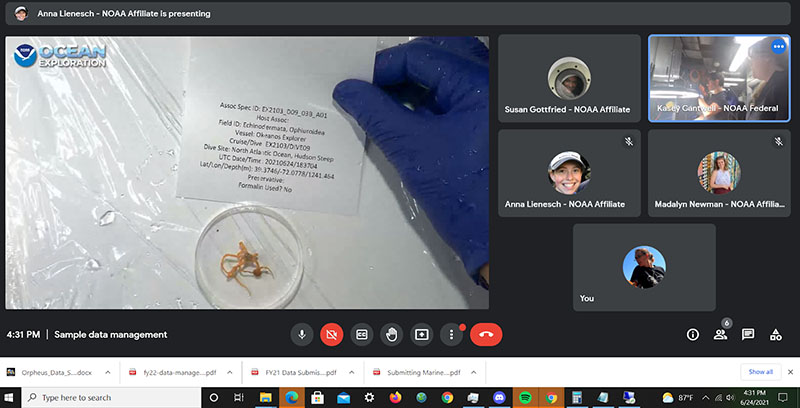
The onboard ship team works with the onshore data sample managers to process a small brittle star that was collected during Dive 09 of the 2021 ROV Shakedown. Image courtesy of NOAA Ocean Exploration, 2021 ROV Shakedown. Download largest version (jpg, 499 KB).
The National Centers for Environmental Information (NCEI) works with NOAA Ocean Exploration and the Global Foundation for Ocean Exploration (GFOE) to manage the data collected onboard NOAA Ship Okeanos Explorer and by remotely operated vehicle (ROV) Deep Discoverer (D2). In addition to high-definition video data and environmental parameters such as water temperature, salinity, dissolved oxygen, location, and depth, D2 collects highly valuable biological and geological specimen samples. Managing these physical samples from the depths of our ocean is high-priority work. Biological samples may lead to new species identifications, range extensions, or medical advancements, while geological samples may unlock secrets of how a seamount formed or where a tsunami originated. In most cases, the areas in which samples are collected have never been explored.
Without proper management of these samples and the accompanying metadata samples may be unusable to future scientists. Metadata answers important questions like when, where, why, how, by whom, and under what conditions a sample was collected. The inaccurate recording of metadata, like where a new species was collected, may have detrimental consequences. To ensure this never happens, NOAA NCEI carefully organizes and maintains the accompanying metadata, environmental parameters, as well as images and videos. NOAA NCEI also ensures that scientists and the public have access to all sample-related information needed to fully understand the entire environment from which the sample was collected. The sample data manager frequently participates in ROV expeditions from the ship, physically working in the wetlab with the onboard scientists to manage the samples.
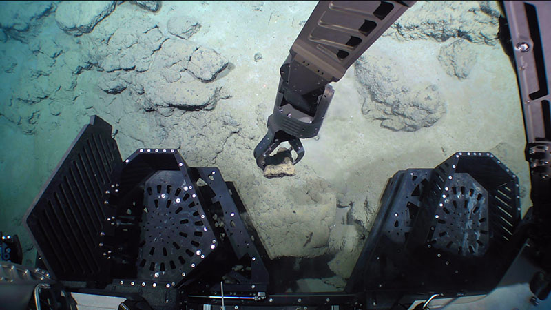
This rock sample was collected at a depth of 4,170 meters (13,681 feet) during Dive 05 of the 2021 North Atlantic Stepping Stones expedition, while exploring Rockaway Seamount. Image courtesy of NOAA Ocean Exploration, 2021 North Atlantic Stepping Stones: New England and Corner Rise Seamounts. Download largest version (jpg, 981 KB).
When it’s not possible to be onboard the ship, as is the case during the 2021 North Atlantic Stepping Stones expedition, NOAA NCEI sample managers operate many of the sample data management tasks from shore. While scientists onboard the ship perform the tasks of physically processing samples in the ship’s wetlab, the NCEI data team participates virtually via the ship’s telepresence technologies. From shore, the NCEI data team creates physical labels for the samples, records information provided from the scientists onboard or from onshore in a sample database, manages the wetlab images taken from onboard scientists during sample processing, extracts the relevant seafloor video and images associated with the samples, and produces sample reports.
During exploration of MacGregor Seamount on Dive 08 of the 2021 North Atlantic Stepping Stones expedition, the team collected a small piece of an octocoral in the family Plexauridae that may be a new species. This image of the collected sample was taken in the wetlab on NOAA Ship Okeanos Explorer as part of the sample data management process to record metadata about the specimens such as size. Image courtesy of NOAA Ocean Exploration, 2021 North Atlantic Stepping Stones: New England and Corner Rise Seamounts. Download largest version (jpg, 6.3 MB).
While this sounds relatively simple, the scientists have encountered many challenges along the way which have required creative solutions to solve! For example, virtual sample data management has a higher risk for metadata loss and recording errors. To accommodate for this, NOAA NCEI uses two shore-side sample data managers to provide redundancy through internet connectivity issues and to ensure data accuracy. The shore-based sample data managers owe many thanks to the expedition coordinators, participating scientists, and GFOE for helping NOAA NCEI meet and overcome these challenges. This collaboration has directly contributed to the successful management of physical samples.
The manipulator arm of remotely operated vehicle Deep Discoverer is used to clip a branch off a bamboo coral during Dive 02 of the 2021 North Atlantic Stepping Stones expedition. A small anemone was observed living on the coral, causing the coral to create small, basket-like branches around the anemone. The collected sample, once processed and made available to scientists, may help scientists better understand the relationship between the anemone and its coral host. Image courtesy of NOAA Ocean Exploration, 2021 North Atlantic Stepping Stones: New England and Corner Rise Seamounts. Download largest version (jpg, 1.1 MB).
The biological specimens and accompanying metadata are submitted to the National Museum of Natural History, Smithsonian Institution where they are archived in the Invertebrate Zoology Collections , while the geological specimens and accompanying metadata are submitted to the Marine and Geology Repository at Oregon State University . All sample data, along with all NOAA Ocean Exploration data, can be found through the NOAA Ocean Exploration Data Atlas. A GIS service of all D2 sample locations can be found here . All NOAA Ocean Exploration ArcGIS Online services are located within the NOAA Ocean Exploration (NCEI) Data group.


