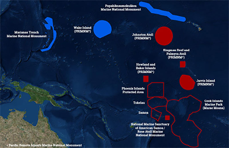

This map shows the U.S. Marine National Monuments in the Pacific Ocean (solid blue and solid red polygons) – the focus of operations for 2015-2017. The 2017 expeditions will take place in the central Pacific, focusing efforts in the vicinity of the Hawaiian archipelago; the Kingman/Palmyra, Jarvis, and Howland/Baker units of the Pacific Remote Islands Marine National Monument (PRIMNM), now known as Pacific Islands Heritage Marine National Monument; National Marine Sanctuary of American Samoa; and Rose Atoll Marine National Monument.
In January 2017, NOAA Ship Okeanos Explorer began her third and final year in an effort to investigate the rich biodiversity and dynamic geology in deepwater environments of the U.S. central and western Pacific Ocean. The purpose of this three-year exploration campaign, titled the Campaign to Address Pacific monument Science, Technology, and Ocean NEeds (CAPSTONE), is to systematically collect baseline information to support science and management needs within and around marine monuments and other protected places in the Pacific. The campaign serves as an opportunity for NOAA and the nation to highlight the uniqueness and importance of these national symbols of ocean conservation.
Areas of exploration this year have included southern portions of the Pacific Remote Islands Marine National Monument (PRIMNM), now known as Pacific Islands Heritage Marine National Monument, the Phoenix Islands Protected Area (PIPA), Tokelau, the Cook Islands, American Samoa and Samoa, areas off the Swains Atoll in American Samoa, and the high seas.
Information on recent expeditions can be found here.
Largely unexplored, the PRIMNM is the largest marine protected area in the world [370,000 square nautical miles (1,269,065 square kilometers)] and is inhabited by the most widespread collection of marine life under the jurisdiction of a single country (the U.S.). From July 7 to August 2, scientists will explore the Johnston Atoll Unit of the PRIMNM at depths between 250 and 6,000 meters. There, the team will collect biological survey data – including midwater transects, looking for deep-sea ferromanganese crust habitats, and further exploring the geological history of the seafloor in this remote region of the Pacific Ocean. For more information on the deep-sea geology of this region, explore these recent essays:

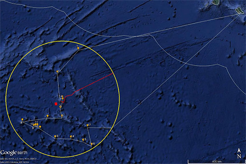
Map showing the generalized cruise track (white lines) for the Johnston Atoll exploration. The ship will transit from Oahu to dive site 1 (1 on the map) located in the northeast of the Johnston Atoll Unit (the yellow circle). Planned dive sites are shown as orange dots and numbered in planned dive site order.
During this expedition, the exploration strategy of NOAA Ship Okeanos Explorer will be employed: bathymetric mapping using multibeam sonar; water column exploration using a Conductivity, Temperature and Depth (CTD) Profiler; and remote imaging and filming with remotely operated vehicle (ROV) Deep Discoverer. Scientists from around the world will be participating in the exploration in real time through telepresence technology. Students and the general public can watch ROV dives live and listen to scientists discussing the footage on the NOAA Ocean Explorer website.