By Christopher Kelley - University of Hawaii at Manoa
Diva Amon - University of Hawaii at Manoa

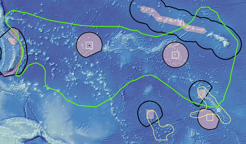
Figure 1: Pacific Prime Crust Zone (PCZ) boundary (green) shown in comparison to the U.S. Pacific monuments (pink) and U.S. EEZ boundaries (black). The PCZ extends from the Hawaiian Islands in the east to the border of the Mariana Trench in the west. Image courtesy of Christopher Kelley. Download larger version (jpg, 1.7 MB).
Commercial deep-sea mining is presently in an exploratory phase, but is certain to occur because of the expected need for minerals that are rapidly being depleted from terrestrial sources. The deep sea is a rich source of these minerals, which can be found on the seafloor in the form of polymetallic nodules, polymetallic sulphides, and cobalt-rich ferromanganese (Fe-Mn) crusts.
While nodule and polymetallic-sulphide mining will likely occur first, cobalt-rich ferromanganese-crust mines will not be far behind due to their high value and rich concentrations of cobalt, nickel, manganese and other metals.
An area in the Central Pacific called the “Prime Fe-Mn Crust Zone (PCZ)” has already been identified as being of the greatest economic interest in the world for mining mineral-rich crusts. Modeling of future mine sites in the PCZ is presently being carried out to identify the best locations for these activities.

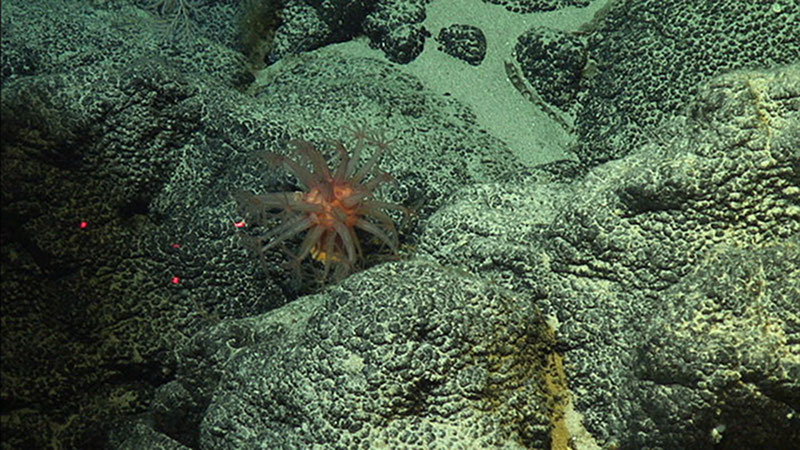
Cobalt-rich ferromanganese crust with batraoidal (bubbly) appearance characteristic of older, thicker deposits. Image courtesy of Christopher Kelley. Download larger version (jpg, 1.4 MB).
Figure 1 shows the boundaries of the PCZ relative to the boundaries of all of the U.S. monuments in the Pacific and the U.S. Exclusive Economic Zone (EEZ). As is clearly shown in this map, President Obama’s expansion of the Pacific Remote Islands Marine National Monuments, now known as Pacific Islands Heritage Marine National Monument in 2014 provided protection against mining activities for a significant area of the PCZ, which may turn out to be the most important benefit from this act in the future.
The western half of the PCZ has some of the oldest seafloor in the Pacific and consequently this area may have some of the thickest, most valuable crusts. This part of the zone is receiving the most commercial attention and is located strikingly close to the Commonwealth of the Northern Mariana Islands (CNMI) and the Mariana Trench Marine National Monument (MTMNM), which will be visited during the upcoming expedition.
The International Seabed Authority (ISA) is the organization that oversees deep-sea mining activities within international waters, and has already approved three exploration contracts for Fe-Mn crust extraction in the Western Pacific for the Ministry of Natural Resources and Environment of the Russian Federation, the Japan Oil, Gas and Metals National Corporation (JOGMEC), and the China Ocean Mineral Resources Research and Development Association (COMRA).

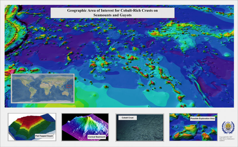
Map showing the ISA’s current area of most interest for Fe-Mn crust mining in the western part of the PCZ in the Pacific. Image courtesy of ISA. Download larger version (jpg, 2.9 MB).
The optimal depth range for mining crusts is 1,500-2,500 meters (4,500-7,500 feet). The process will involve the removal of the top mineral-rich layer of the substrate along with all of the benthic animals that may be living on it.
Those involved in planning for this new industry are aware of the potentially severe ecological consequences of crust mining; however; it is not clear what measures can and should be taken to avoid irreparable harm to the benthic communities in the Pacific.
The deep seafloor of the Pacific Ocean is one of the most poorly explored regions on Earth with very little known about the benthic animals that live beyond 1,000 meters (3,000 feet) in the PCZ. Recent surveys of crust communities in the Papahanaumokuakea Marine National Monument in the Northwestern Hawaiian Islands have found dense beds of corals, sponges, and other invertebrates living on crusts at these depths, many of which are new to science and are thought to be long-lived and fragile.

Map of the Western Pacific showing the locations of Mn crust exploratory sites granted by the ISA. Image courtesy of ISA. Download larger version (jpg, 2.7 MB).
It is clear that crucial baseline information is needed in order to gain a better understanding of the communities that are at risk and put measures in place to mitigate the impacts of mining and help preserve these unique communities. The ISA has stated its commitment to ensure harmful effects from deep-sea mining are minimized. The following is an excerpt from their website:
“As part of its substantive work programme, the Secretariat of the Authority also carries out detailed resource assessments of the areas reserved for the Authority; maintains a specialised Database (POLYDAT) of data and information on the resources of the international seabed area and monitors the current status of scientific knowledge of the deep sea marine environment as part of its ongoing development and formulation of the Central Data Repository. The Authority also continues to promote and encourage: Marine scientific research in the international seabed Area through its Endowment Fund by supporting the participation of qualified scientists and technical personnel from developing countries in marine scientific research programmes and activities and by providing opportunities to these scientists to participate in relevant initiatives.”
During this expedition, the scientists are aiming to conduct some of the first-ever surveys of Fe-Mn crust habitats on seamounts within the U.S. EEZ surrounding Guam and the CNMI and inside the PCZ very close to the ISA’s approved exploratory mining sites. The information obtained from these dives will be helpful to the ISA and others interested in deep-sea mining, its potential consequences, and in ensuring that mining proceeds in an informed and careful manner in the future.