This media resources page provides members of the media with information; resources; and broadcast-, print-, and web-quality imagery developed during the Océano Profundo 2015: Exploring Puerto Rico’s Seamounts, Trenches and Troughs expedition.
Beginning in February 2015, the NOAA Office of Ocean Exploration and Research will lead a three-leg expedition aboard NOAA Ship Okeanos Explorer to explore unknown and poorly known deepwater regions around Puerto Rico and the U.S. Virgin Islands.
The ship will stop in San Juan between each leg.
On this page: Why? | Who? | Highlight Images and Videos | Press Releases | Background Info | Contact Info
This expedition will be some of the first deepwater exploration work ever conducted in targeted areas of the Caribbean, including the Puerto Rico Trench. We anticipate encountering deepwater habitats similar to what we have seen on other expeditions. In addition, we expect to improve understanding of seismic interactions in a tectonically active part of the ocean and gain knowledge about deepwater fisheries in the Caribbean.
It is important to explore this area for several reasons:
The specific areas we will be exploring were identified by the ocean exploration community in 2013 as priorities for ocean exploration within the Caribbean region. The expedition will build on other exploration work done in the region by partners such as the Ocean Exploration Trust and NOAA National Ocean Service.
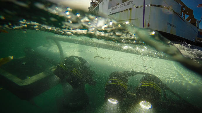
Following two legs to collect baseline seafloor mapping data in targeted areas, the expedition will include approximately 20 remotely operated vehicle (ROV) dives, all of which will be live-streamed so scientists and the public can follow along. In addition, seafloor depth, bottom backscatter, water-column backscatter, sub-bottom profiles, and water temperature profile data will be collected with the ship’s sonars and XBT probes.
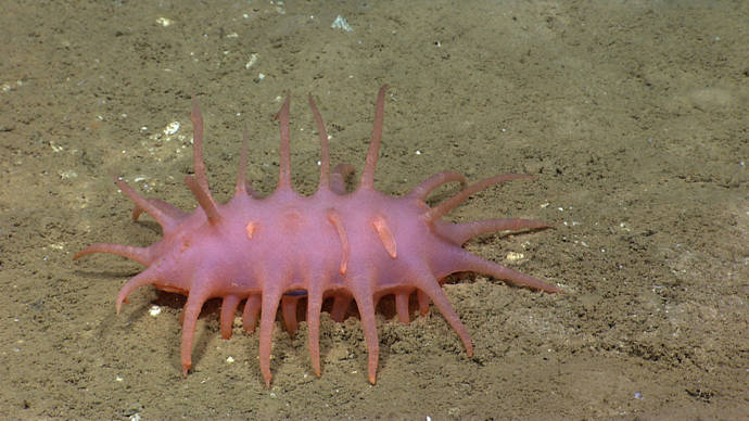
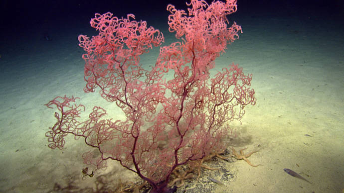
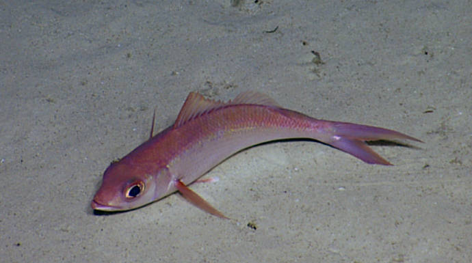
As one of the deepest places in the ocean, the Puerto Rico Trench offers opportunities for cutting-edge exploration of some of the least-understood habitats on the planet:
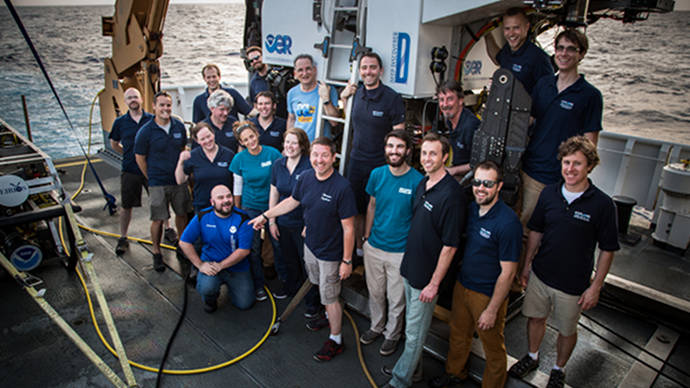
Activities during the third leg of the expedition will be primarily led by the four scientists listed below. They will coordinate input from multiple scientists participating from shore to plan dives, are the voices you hear on the live video feeds, and are primary participants in outreach events. For a full list of our on-ship team, please visit the Explorers page.

Science Co-Lead - Postdoctoral Researcher, U.S. Geological Survey Southeast Ecological Science Center
Dr. Quattrini is serving as the biological science lead during this expedition. She will help to coordinate the science objectives of both the shore-based and ship-based science teams during the exploration of poorly known deep-sea habitats around Puerto Rico and the U.S. Virgin Islands. Dr. Quattrini is interested in how biodiversity is generated and maintained in the deep sea. Specifically, she focuses on the relative roles of habitat heterogeneity and dispersal in shaping deep-sea coral and fish communities. Since 2002, she has participated in 22 research cruises using deep-submergence vehicles; she also has extensive experience with telepresence-enabled cruises. Dr. Quattrini is currently a post-doctoral researcher at the U.S. Geological Survey Southeast Ecological Science Center, in Gainesville, Florida. She received a Ph.D. in biology from Temple University, an M.S. in marine biology from the University of North Carolina at Wilmington, and a B.S. in biology from Millersville University.

Science Co-Lead - Associate Professor of Geology, University of Wyoming
Dr. Cheadle is serving as the geological science lead during this expedition. He will help to coordinate the science objectives of both the shore-based and ship-based science teams during the exploration of poorly known deep-sea habitats around Puerto Rico and the U.S. Virgin Islands. Dr. Cheadle is a geologist/geophysicist who studies the creation of oceanic crust at mid-ocean ridges. He became interested in marine exploration midway through his career after realizing that ocean basins are one of the last great frontiers of exploration on Earth. Dr. Cheadle has sailed on many U.S.- and Japanese-led research cruises and has studied mid-ocean ridges in the Atlantic, Indian, and Pacific oceans. He and his students have previously participated in Okeanos Explorer and Nautilus telepresence-enabled missions as on-shore scientists. Dr. Cheadle is an associate professor of geology at the University of Wyoming, in Laramie, Wyo. He holds a Ph.D. in geophysics from University of Cambridge, an M.S. in geophysics from Cornell University, and a B.A. in geology from Oxford University.

Expedition Coordinator - NOAA Office of Ocean Exploration and Research
In his role as expedition coordinator, Lt. Kennedy is responsible for overseeing all aspects of an expedition, including arranging logistics, planning science operations, and coordinating public outreach. Since joining the NOAA Corps, he has participated in or led more than 25 expeditions of exploration that have taken him to two oceans (Atlantic and Pacific), three continents (North America, South America, and Asia), and through the waters of six countries (the U.S., Ecuador, Panama, Costa Rica, Honduras, and Indonesia). Originally from landlocked Athens, Georgia, Lt. Kennedy grew up fascinated with marine mammals and the ocean. He holds a B.S. in marine biology with a minor in marine geology from the College of Charleston, in South Carolina.

Mapping Lead - Physical Scientist/Hydrographer, NOAA Office of Ocean Exploration and Research
Mr. Sowers is a physical scientist/hydrographer with the NOAA Office of Ocean Exploration and Research. During at-sea expeditions, he leads sonar data collection by planning the ship’s mapping routes and producing maps of seafloor and water column features to guide exploration. On shore, Mr. Sowers works at the Center for Coastal and Ocean Mapping/Joint Hydrographic Center at the University of New Hampshire to coordinate future mapping expeditions, process and archive data, and collaborate with other scientists. He has 14 years of previous coastal research and management experience, including with NOAA’s National Estuarine Research Reserve network and the Environmental Protection Agency's National Estuary Program, in both Oregon and New Hampshire. Mr. Sowers has participated in ocean research expeditions in the Arctic Ocean, Gulf of Maine, Gulf of Mexico, Pacific Northwest continental shelf, North Atlantic Canyons, and New England Seamounts. He holds a B.S. in environmental science from the University of New Hampshire and an M.S. in marine resource management from Oregon State University. He is also a part-time oceanography Ph.D. student focused on using Extended Continental Shelf and Okeanos Explorer data to develop marine ecological classification maps.
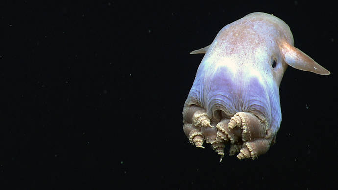
Dive highlight videos, short video clips, and photos for the Océano Profundo: Exploring Puerto Rico's Seamounts, Trenches and Troughs 2015 expedition will be posted on this page as they are available.
Access LIVE video feeds here.
For videos and images from our Puerto Rico Trench 2003 expedition, which took place near the areas we will be exploring this year, visit this page.Please see the Contact Us page for information regarding specific media, public, and government inquiries.