Dive highlight videos, short video clips, and photos for the Océano Profundo: Exploring Puerto Rico's Seamounts, Trenches and Troughs 2015 expedition for members of the media will be posted here as they are available.
Unless otherwise noted, all videos and images posted here are in the public domain and are thus free for use and reproduction. Please credit NOAA Office of Ocean Exploration and Research.
Access LIVE video feeds here.
For videos and images associated with mission updates and logs, visit this page.

This map shows the areas NOAA Ship Okeanos Explorer will explore during the 20 ROV dives to be conducted between April 9 and 30 in and around the Puerto Rico Trench and the U.S. Virgin Islands. Data displayed provided by ESRI, Delorme, GEBCO, USGS, NOAA NGDC, and other contributors; map created with ESRI ArcMap software. Image courtesy of the NOAA Office of Ocean Exploration and Research. Download larger version (jpg, 473 KB).
 of the northeast corner of the Caribbean Plate, including the Puerto Rico Trench, collected during a 2003 U.S. Geological Survey expedition to the Puerto Rico Trench funded by NOAA's Office of Ocean Exploration and Research. The complex bathymetry of the seafloor of this region is a consequence of plate tectonics, the theory that describes the large-scale motion of the various plates that make up the outer shell of the earth.")
Bathymetry (underwater topography) of the northeast corner of the Caribbean Plate, including the Puerto Rico Trench, collected during a 2003 U.S. Geological Survey expedition to the Puerto Rico Trench funded by NOAA's Office of Ocean Exploration and Research. The complex bathymetry of the seafloor of this region is a consequence of plate tectonics, the theory that describes the large-scale motion of the various plates that make up the outer shell of the earth. Image courtesy of USGS. Download image (jpg, 199 KB).
 follow live video from the seafloor during each Okeanos Explorer expedition.")
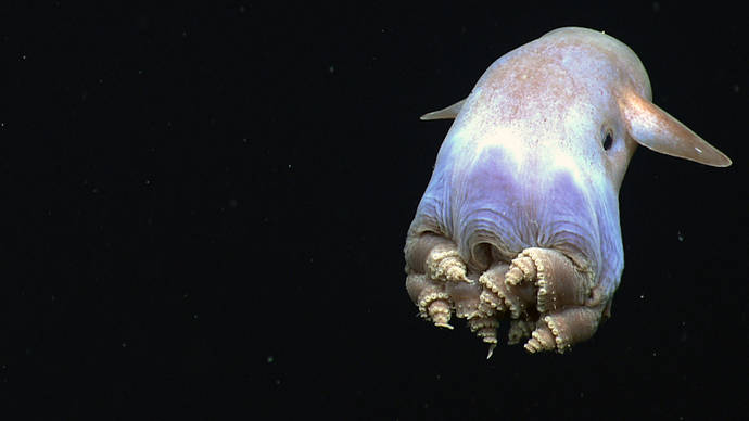
A dumbo octopus displays a body posture never before observed in cirrate octopods. Unprecedented sights like this are one of the reasons dozens of scientists (and hundreds of thousands of members of the public) follow live video from the seafloor during each Okeanos Explorer expedition. Image courtesy of the NOAA Office of Ocean Exploration and Research. Download large version (jpg, 1.0 MB).

These chemosynthetic mussels were discovered by the ROV Deep Discoverer while it explored a canyon off the northeast coast of the U.S. in 2013. Over 800,000 members of the public tuned in to the video the ROV live-streamed over the internet during this expedition. Chemosynthetic mussels are found in areas of active hydrocarbon seepage; NOAA Ship Okeanos Explorer has discovered hundreds of previously unknown methane seeps in this and other areas over the past five years. Image courtesy of the NOAA Office of Ocean Exploration and Research. Download large version (jpg, 1.5 MB).

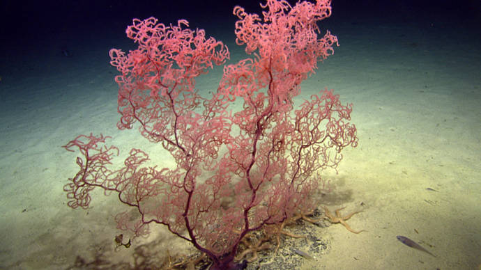
During a 2014 expedition on the Ocean Exploration Trust's ship, Nautilus, to areas just off the coast of the British Virgin Islands, the ship's ROV came across this large colony of black coral. Scientists aboard NOAA Ship Okeanos Explorer hope to see similar deep-sea corals when they explore the nearby Puerto Rico Trench in April. NOAA's Office of Ocean Exploration and Research funds about half of the nonprofit Ocean Exploration Trust's operating costs. Image courtesy of Ocean Exploration Trust. Download large version (jpg, 1.9 MB).

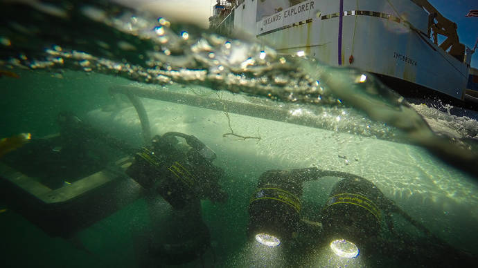
Okeanos Explorer's dual-body ROV system is loaded from the aftdeck of the ship into the water before conducting an exploration dive. Image courtesy of the NOAA Office of Ocean Exploration and Research. Download large version (jpg, 464 KB).

The Okeanos Explorer control room just before the start of an ROV dive. The control room is where the ROV pilots, the science leads, and other expedition personnel work during an ROV dive. Image courtesy of the NOAA Office of Ocean Exploration and Research. Download large version (jpg, 1.2 MB).