


NOAA Ship Okeanos Explorer: 2022 Expeditions Overview
Completed
Overview
In 2022, NOAA Ocean Exploration will spend more than 200 days at sea while exploring two ocean basins. From February through mid-August, NOAA Ocean Exploration will continue operations in the deep waters of the North Atlantic Ocean on NOAA Ship Okeanos Explorer. After we wrap up our work in the Atlantic, we’ll transit through the Panama Canal and kick off our return to the Pacific with a mapping expedition along the U.S. West Coast this fall.

Download largest version (jpg, 3.1 MB).
In 2022, NOAA Ocean Exploration plans to complete the Atlantic Seafloor Partnership for Integrated Research and Exploration (ASPIRE) campaign in support of the Galway Statement on Atlantic Ocean Cooperation with expeditions focused on the Southeast United States, the Caribbean, and the Mid-Atlantic Ridge. ASPIRE is a major multiyear, multinational, collaborative ocean exploration campaign that is increasing our understanding about the biological, geological, chemical, and physical characteristics of the North Atlantic Ocean and providing timely and actionable information to support decision-making.
In the Pacific, the west coast expedition will be part of the EXpanding Pacific Research and Exploration of Submerged Systems (EXPRESS) campaign. This major west coast field program is a multiyear, multipartner cooperative research campaign designed to collect deep-sea data to guide wise use of living marine resources and habitats, inform ocean energy and mineral resource decisions, and improve offshore hazard assessments.
Throughout the field season, we will work with other U.S. federal agencies, including the U.S. Geological Survey and the Bureau of Ocean Energy Management, as well as academic and international partners.
The Atlantic
Following winter maintenance and repairs to Okeanos Explorer, NOAA Ocean Exploration will conduct a shakedown of mapping and remotely operated vehicle (ROV) systems in and around the Florida Straits. We will then transit to San Juan, Puerto Rico, for two mapping expeditions, where we will work toward completion of the deepwater mapping in the U.S. Exclusive Economic Zone around Puerto Rico. During the second mapping expedition, we will introduce and test two deep-sea camera systems. These cameras, which will be attached to the conductivity, temperature, and depth (CTD) rosette, will collect still images and video of the water column and seabed, helping to further our understanding of these mysterious places.
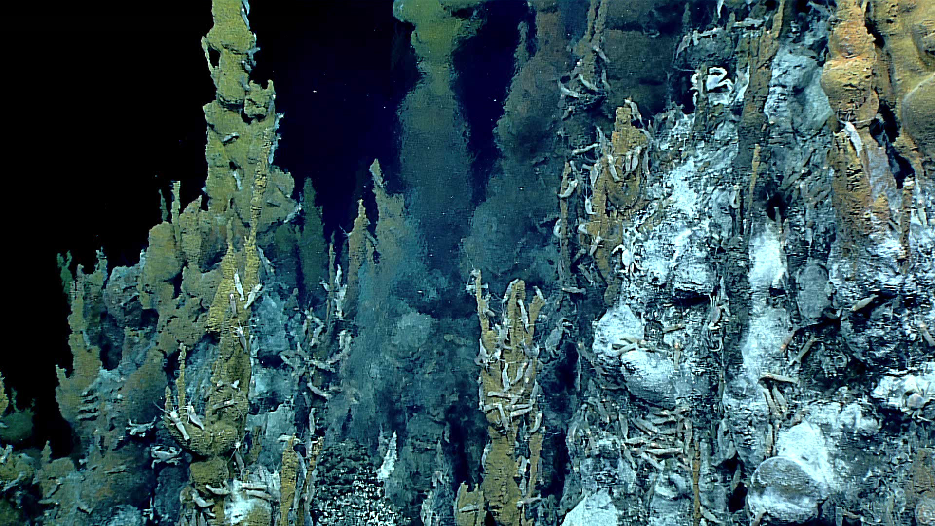
Next stop, the high seas of the North Atlantic. NOAA Ocean Exploration’s Voyage to the Ridge is a series of three expeditions to explore the Mid-Atlantic Ridge, Azores Plateau, and Charlie-Gibbs Fracture Zone. Geologically, this includes a divergent plate boundary, volcanism, and hydrothermal vents. Biologically, we anticipate a variety of marine life supported by the hydrothermal vents and an abundance of hard seafloor that includes migration corridors that run through the region connecting the eastern and western shores of the Atlantic basin. Mapping and ROV operations will provide much needed insight into these unique and unexplored deepwater areas.
Download largest version (jpg, 1.9 MB).
The Pacific
With the conclusion of ASPIRE activities in the North Atlantic, NOAA Ocean Exploration will make a move to the Pacific via the Panama Canal. Initial west coast activities will include dockside repairs (if necessary) and operations in support of EXPRESS campaign priorities.
Planned Expeditions
- February 23-March 3, 2022: 2022 Mapping and ROV Shakedown (EX-22-01)
Starting in Pascagoula, Mississippi, and ending in Key West, Florida - March 10-28, 2022: 2022 Caribbean Mapping (EX-22-02)
Starting in Key West, Florida, and ending in San Juan, Puerto Rico - April 4-28, 2022: 2022 Puerto Rico Mapping and Deep-Sea Camera Demonstration (EX-22-03)
Starting in San Juan, Puerto Rico, and ending in Newport, Rhode Island - May 11-June 7, 2022: Voyage to the Ridge 2022 1 (Mapping) (EX-22-04)
Starting in Newport, Rhode Island, and ending in St. Johns, Newfoundland (Canada) - July 9-30, 2022: Voyage to the Ridge 2022 2 (ROV and Mapping) (EX-22-05)
Starting in Norfolk, Virginia, and ending in Horta, Faial, Azores (Portugal) - August 6-September 2, 2022: Voyage to the Ridge 2022 3 (ROV and Mapping) (EX-22-06)
Starting in Horta, Faial, Azores (Portugal), and ending in San Juan, Puerto Rico - September 10-October 3, 2022: Transit to the West Coast (EX-22-07)
Starting in San Juan, Puerto Rico, and ending in San Diego, California - October 16-November 6, 2022: EXPRESS: West Coast Mapping 2022 (EX-22-08)
Starting in San Diego, California, and ending in Newport, Oregon
Participation in the Expeditions
While we’re at sea, telepresence allows anyone to join us virtually. Livestreamed video on the NOAA Ocean Exploration website brings the joy of discovery to the shore in real time.
We are currently seeking scientists and managers interested in actively participating during our 2022 expeditions. For details about opportunities to get involved, visit the NOAA Ship Okeanos Explorer: Get Involved web page. If you are interested in providing input into expedition planning or participating as a scientist or student, contact our expeditions science advisor, Scott France, at france@louisiana.edu.
Data Access
NOAA Ocean Exploration ensures public access to scientific data and information collected during expeditions on Okeanos Explorer. Data collections typically include oceanographic and geophysical parameters, video, images, documents, and more, provided in a range of data formats. Data are available in NOAA’s public data archives within 60-90 days of the end of an expedition and are accessible via the NOAA Ocean Exploration Data Atlas.