


What is backscatter?
Backscatter is the sound energy that is reflected back to its source after hitting the seafloor or objects in the water column. The strength of this energy provides insight into the characteristics of the unseen underwater world.

While mapping Vailuluʻu Seamount in 2017, backscatter data collected with NOAA Ship Okeanos Explorer’s multibeam sonar system revealed a plume of bubbles rising from the seafloor, suggesting the presence of hydrothermal activity. In this image, the plume is visible in the water column backscatter (the blue and green cone) overlaid on the seamount’s bathymetry. Image courtesy of NOAA Ocean Exploration, 2017 American Samoa. Download largest version (jpg, 359 KB).
Two types of acoustic data are used together to map the ocean: bathymetric data and backscatter data. Both provide important information about the seafloor. Bathymetric data help scientists understand the depth and shape of the seafloor; backscatter data help them understand what it’s made of. Backscatter data are also used to detect objects in the water column, such as large organisms, groups of small organisms (e.g., the deep scattering layer), shipwrecks, and bubble plumes and particles (like minerals and sulfides), which may be indicative of cold seeps, hydrothermal vents, or underwater volcanoes.
Both seafloor and water column backscatter data can shed light on life in the deep. The degree of seafloor hardness matters for a lot of benthic species. Some animals, like corals and sponges, prefer hard surfaces upon which they can attach and grow, often creating habitat for other animals, including commercially important fish. Softer surfaces are preferred by animals that like to dig and burrow, for food as well as protection. Once scientists know what the seafloor is made up of, they can infer the life it supports.
In the water column, backscatter data enable scientists to estimate fish abundance, size, and density; track movement; and sometimes identify species. Gas bubbles can call attention to chemosynthetic features on the seafloor and the unique life forms that inhabit them.
Scientists use a variety of sonar systems to measure backscatter. These systems send beams of sound into the water column. When the sound energy hits the seafloor or something in the water column, some of it is reflected back to its source. It’s the strength of this returned energy — or backscatter — that gives scientists clues about what lies below.
Backscatter strength is determined by the hardness and roughness of the seafloor and the composition of objects encountered in the water column. Different bottom types, for example, reflect sound energy differently; a hard rocky seafloor or coral reef generally reflects more sound, returning a stronger signal than softer materials like mud or sand, which tend to absorb sound, and a smooth surface tends to reflect more sound than a rough one.
Today, multibeam and split-beam sonar systems are the main tools used to measure backscatter. Multibeam systems mounted on ships and uncrewed surface vessels measure seafloor bathymetry and seafloor and water column backscatter simultaneously and continuously over a wide area. Split-beam systems mounted on surface and underwater platforms emit single beams, making them more narrowly focused and less efficient than multibeam systems. But, with multiple frequencies for detecting objects of varying sizes, they’re more precise, making them ideal for measuring water column backscatter. Used together, multibeam systems provide the “big picture” of an area and split-beam systems provide the details.
By integrating backscatter data with bathymetric data, scientists can more comprehensively map the ocean, from the surface to the seafloor, in deep and shallow waters. Using backscatter data to fill gaps in our biological and geological knowledge of the ocean makes scientists better able to detect geological features and hazards, assess and manage fisheries, monitor changes in the ocean over time, support sub-sea infrastructure decisions, ensure safe navigation, and more.
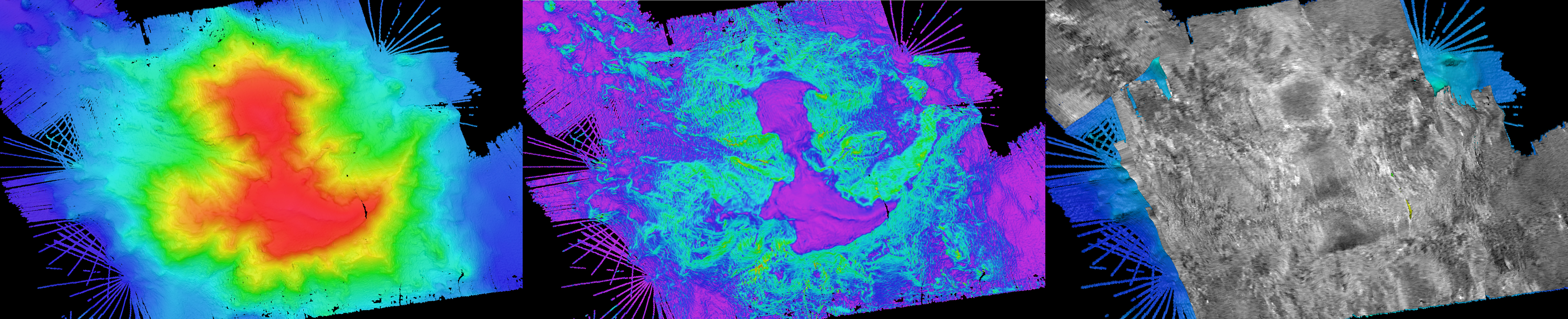
During expeditions on NOAA Ship Okeanos Explorer, the science team uses backscatter data along with other data to inform dive targets and guide water column exploration. From left to right, these diving planning products show bathymetry (shape), slope (steepness), and backscatter (relative hardness) for Michael Seamount in the New England Seamounts. Image courtesy of NOAA Ocean Exploration, 2021 North Atlantic Stepping Stones. Download largest version (jpg, 4.3 MB)