Project Summary

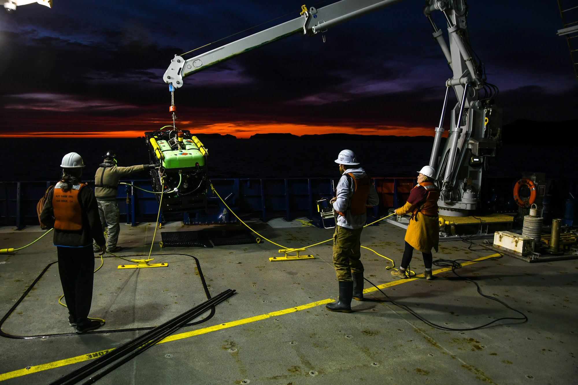
From January 2-12, 2023, the SEASCAPES project team conducted the third phase of the project, which involved remote operated vehicle (ROV) surveys aboard Research Vessel Sally Ride. Over the course of 13 ROV dives, the team discovered what represents the first known shallow-water cold seep field in the southern California region.

The Student Explorations Around Southern California: Acoustics, Paleolandscapes, and Environments at Sea (SEASCAPES) project science team and some ship crew aboard Research Vessel Sally Ride during the third phase of the project.
The Student Explorations Around Southern California: Acoustics, Paleolandscapes, and Environments at Sea (SEASCAPES) project science team and some ship crew aboard Research Vessel Sally Ride during the third phase of the project. Image courtesy of Student Explorations Around Southern California: Acoustics, Paleolandscapes, and Environments at Sea (SEASCAPES). Download largest version (jpg, 651 KB).

During this third phase of the project, the team was joined by several engineers with Marine Applied Research and Exploration (MARE) who operated their ROV Beagle, 10 students learning ocean science research, 1 science illustrator, and a representative from the Santa Ynez Band of Chumash Indians. The team collected 3 terabytes (TB) of photographic stills and video during 36 hours and 48 minutes of time on the seafloor on the 13 ROV dives. The focus for these dives were paleolandscapes in less than 120 meters (394 feet) of water off the Northern Channel Islands, California (34.056267°N 119.406689°W).

The Student Explorations Around Southern California: Acoustics, Paleolandscapes, and Environments at Sea (SEASCAPES) project science team and Research Vessel Sally Ride crew deploy remotely operated vehicle Beagle for a dive off Anacapa Island.
The Student Explorations Around Southern California: Acoustics, Paleolandscapes, and Environments at Sea (SEASCAPES) project science team and Research Vessel Sally Ride crew deploy remotely operated vehicle Beagle for a dive off Anacapa Island. Image courtesy of Amy Gusick. Download largest version (jpg, 1.06 MB).
The Marine Applied Research and Exploration (MARE) remotely operated vehicle operator (far left) flies the equipment at depth while the Student Explorations Around Southern California: Acoustics, Paleolandscapes, and Environments at Sea (SEASCAPES) project science team and ship crew monitor the video output.
The Marine Applied Research and Exploration (MARE) remotely operated vehicle operator (far left) flies the equipment at depth while the Student Explorations Around Southern California: Acoustics, Paleolandscapes, and Environments at Sea (SEASCAPES) project science team and ship crew monitor the video output. Image courtesy of Jillian Maloney. Download largest version (jpg, 1.58 MB).

The initial plan for ROV dives was to locate and sample possible tar seep (hydrocarbon) locations inferred from data previously collected as part of the project with controlled source electromagnetic (CSEM) instruments on surveys in October 2021 and in March 2022 with an Edgetech Chirp sub-bottom profiler. Areas planned for survey included three locations off the Northern Channel Islands and two locations near to the California mainland.

Severe weather – the "atmospheric storms" that hit the West Coast during early January 2023 – made surveys in all regions, except for one, unsafe due to the high sea state or not useful due to very poor visibility from high turbidity. The only planned exploration area that was relatively safe with decent visibility was north of Anacapa Island. This area had a lower potential than others for presence of tar seeps, but did show some form of hydrocarbon present in the geophysical data. Ultimately, the majority of ROV surveys and all sample collection occurred in the area north of Anacapa Island.

During ROV Dives 3 and 8, the team did identify hydrocarbon and recorded large white bacterial mats that were more than 10 meters (33 feet) across in two bathymetric lows interspersed with outcropping carbonate reefs. Bacterial mats are not necessarily indicative of hydrocarbon seepage; however, the mats were within pockmarks on the seafloor, were collocated with authigenic carbonates and dark sulfur-smelling sediment, and the carbonates, when disturbed, released modest amounts of visible gas bubbles. These observations are consistent with those found at active methane (hydrocarbon) seeps, otherwise known as cold seeps.

Example of an outcrop (carbonate structures) with coral identified during a Student Explorations Around Southern California: Acoustics, Paleolandscapes, and Environments at Sea (SEASCAPES) project dive.
Example of an outcrop (carbonate structures) with coral identified during a Student Explorations Around Southern California: Acoustics, Paleolandscapes, and Environments at Sea (SEASCAPES) project dive. Image from SEASCAPES remotely operated vehicle footage; edited by Roslynn King. Download largest version (jpg, 263 KB).
Example of dark staining of the seafloor with bacteria mats and sea urchins observed during a dive Student Explorations Around Southern California: Acoustics, Paleolandscapes, and Environments at Sea (SEASCAPES) project.
Example of dark staining of the seafloor with bacteria mats and sea urchins observed during a dive Student Explorations Around Southern California: Acoustics, Paleolandscapes, and Environments at Sea (SEASCAPES) project. Image from SEASCAPES remotely operated vehicle footage; edited by Roslynn King. Download largest version (jpg, 243 KB).

This discovery of active methane seepage represents the first known cold seep in shallow water (less than 100 meters) in southern California. The seep has been given the Sʰamala (Chumashan language) name Ma saputiwaxmu', meaning the place where it seeps through, by the Cultural Department at the Santa Ynez Band of Chumash Indians. This tribe is one band of the Chumash people, the original caretakers of the land where the project work was conducted.

During our dives, we collected 14 rock/carbonate samples and 4 sediment samples. While these are not the tar seep samples we had originally planned, the cold seep site samples are currently being analyzed for data to help reconstruct both the paleoenvironment and paleoclimate of the region, a major goal for this project.

The Student Explorations Around Southern California: Acoustics, Paleolandscapes, and Environments at Sea (SEASCAPES) project science team and members of the Research Vessel Sally Ride crew jumping for joy over the fact that they were able to accomplish project goals despite weather setbacks!
The Student Explorations Around Southern California: Acoustics, Paleolandscapes, and Environments at Sea (SEASCAPES) project science team and members of the Research Vessel Sally Ride crew jumping for joy over the fact that they were able to accomplish project goals despite weather setbacks! Image courtesy of Student Explorations Around Southern California: Acoustics, Paleolandscapes, and Environments at Sea (SEASCAPES). Download largest version (jpg, 1 MB).

By Dr. Amy Gusick, Project Co-Principal Investigator (with Jillian Maloney), Curator of Archaeology, Natural Museum of Los Angeles County

Published June 24, 2024

Education Themes

Education theme pages provide the best of what the NOAA Ocean Exploration website has to offer to support your classroom during this expedition. On each theme page, you will find links to expedition features, lessons, multimedia, career information, and associated past expeditions.

Media Contacts

Emily Crum

Communication Specialist
NOAA Ocean Exploration
ocean-explore-comms@noaa.gov


Sally Marquez

Communications Manager
Natural History Museum of Los Angeles
smarquez@nhm.org

Funding for this expedition was provided by NOAA Ocean Exploration via its Ocean Exploration Fiscal Year 2020 Funding Opportunity.