


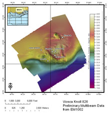
Multibeam data at Viosca Knoll 826 acquired during the Lophelia II cruise. Click image for larger view and image credit.
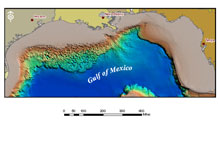
Multibeam bathymetry data for the Gulf of Mexico. Click image for larger view and image credit.
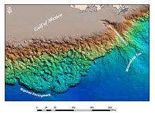
Multibeam bathymetry allows terrain models to be created for large areas of the sea floor. Click image for larger view and image credit.
Mapping the Ocean Floor with Multibeam Bathymetry
September 21, 2008
Michael Robert Kullman
GIS Specialist
TDI-Brooks International
Multibeam bathymetry data – which allows scientists to see the shape of the ocean floor – will be collected at a number of sites during the Lophelia II project. These data will allow scientists to have very accurate water depth and terrain models of the coral reefs being investigated and will serve as a navigational aid during remotely operated vehicle (ROV) operations in these areas. The detailed map and knowledge of the slope of the sea floor acquired from the multibeam data will help with our predictions of the distribution of corals, particularly at sites we have visited before. At the new sites we are visiting, the multibeam data will give us our first detailed look at the bottom in these areas.
To map the sea floor, ocean scientists bounce a beam of sound waves off the ocean bottom through a technique called ‘echo sounding.’ A transducer is used to both transmit and receive sound waves. By measuring the ‘travel time’ of the sound wave from the transducer to the sea floor and back, the water depth at that location can be determined. Research ships moving along the sea surface repeatedly “ping” the sea floor with sound to gather a continuous line of water-depth readings below the vessel. The individual depth readings are combined to create a map of water depths (bathymetry) over an area.
Early echo sounders were only capable of transmitting and receiving a single sound pulse at a time. However, modern multibeam echo sounders, such as the one being used for the Lophelia II project, are capable of sending out many beams of sound simultaneously (up to 120), allowing research vessels to collect data on a wide swath of the sea floor rather than a single line. In this way, much larger areas of the sea floor can be mapped during a single cruise and very accurate terrain models of the sea floor can be produced. Multibeam bathymetry systems are now routinely used to map areas of the sea floor as large as several U.S. states.