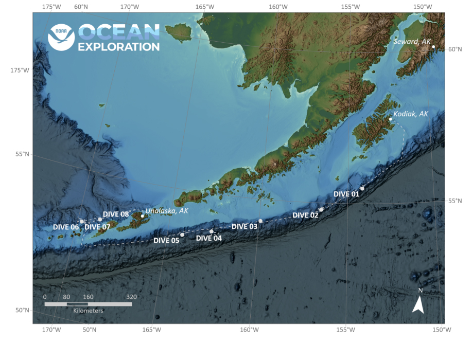
Seascape Alaska 3: Aleutians Remotely Operated Vehicle Exploration and Mapping
(EX2304)
An Introduction to the Geology of the Aleutian Islands
Ocean exploration is vital for mapping and characterizing geologic features and biologic communities in the ocean, some of which have not been previously described. However, the impacts of ocean exploration extend well beyond the ocean, with impacts reaching to rock layers in the high mountains and deep subsurface. By investigating modern tectonic margins and deep-ocean environments, we improve interpretations of ancient rock layers that record the geologic history of our planet.
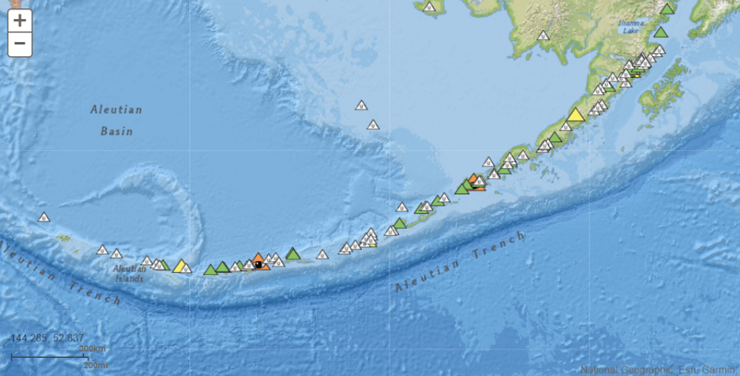
The goal of the series of Seascape Alaska expeditions is to improve knowledge of unexplored areas within Alaskan waters, an area that is still poorly understood. The deep waters offshore of the Aleutian Islands hold the keys to understanding a suite of important and fascinating geologic processes. This active tectonic margin hosts a wide range of geologic activity and features including active volcanoes, faults, frequent earthquakes, natural methane seeps, tsunamis, submarine landslides, natural methane hydrates, and active deep-sea canyons.
The Aleutian Islands have hosted numerous historic volcanic eruptions, earthquakes, and devastating tsunamis, making exploration of this region critical for geohazard assessment and understanding basic geologic processes. Moreover, glacially scoured continental shelves and associated deepwater canyons in water depths of 300 to 2,800 meters (984 to 9,186 feet) offer a unique perspective of past glaciations where glaciers once extended hundreds of miles from the Aleutian Island coastline (Zimmerman et al., 2019). Fault lines and associated sedimentary successions imaged in bathymetry and shallow subsea data and close-up examination by remotely operated vehicles help reconstruct the tectonic assembly of Alaska.
Exploration of this active margin in the deep ocean provides critical insight into the present-day processes that are sculpting our planet. Information contained in the rocks and sediment of this area help geologists interpret the geologic history of Alaska and beyond. Active tectonic margins have a lower potential for preserving the sedimentary rocks that record their history and observing the modern helps geologists piece together the past. Also, the processes of sediment movement and life on the modern seafloor helps us to interpret ancient ocean environments.
Subduction Zones and the Aleutian Subduction Zone
The Earth is a fascinating and dynamic system. The outer surface of the Earth is broken into seven tectonic plates that move very slowly over the Earth’s surface. As these plates interact with one another, they form a wide range of features such as mountain ranges, deep-ocean trenches, fault lines, and an array of others. Areas where the plates interact in modern times are called active margins and are characterized by a range of geologic hazards.
Subduction occurs when plates of differing density converge. The colder, typically older, more dense tectonic plate is pushed below the less dense plate, forcing it back down into the Earth’s mantle. Subduction zones form deep-ocean trenches up to 11,034 meters (36,201 feet) deep at the Mariana Trench) and host some of the largest earthquakes on Earth.
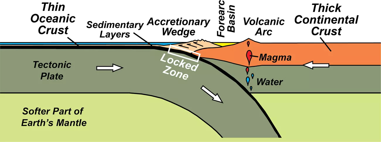
Approximately 45,000 linear kilometers (27,962 miles) of subduction zones exist on the Earth’s surface, and the Aleutian trench is one such subduction zone. The Alaska segment of the Aleutian trench and associated subduction zone extends for nearly 4,000 kilometers (2,485 miles) (Ramos et al., 2022) and is up to 7,823 meters (25,663 feet) deep at a site approximately 90 miles south-southwest of Buldir Island. Subduction at this active margin gives rise to numerous earthquakes and volcanic activity in the Aleutian Islands and forms the Aleutian trench.
The Alaska-Aleutian subduction zone is where the Pacific Plate is obliquely subducting below the North American Plate. The rate at which these plates collide is a convergence rate and this ranges from about 5.6 centimeters (2.2 inches) per year in the eastern Aleutians to about 7.2 centimeters (2.8 inches) per year (some studies suggest rates as high as 8 centimeters/3.2 inches per year) in the western Aleutians (Carver and Pflaker, 2008). The easternmost part of the Pacific Plate subducts obliquely beneath Alaskan continental crust that is 30-40 kilometers (18.6-24.9 miles) thick. Subduction is more “head on” in the eastern end of the Aleutian chain and more oblique in the western Aleutian chain.
Subduction of the Pacific Plate below the North American Plate at the Alaska-Aleutian subduction zone gives rise to volcanoes as crust melts during subduction and numerous earthquakes as it moves. Earthquakes along subduction zones can be very deep and devastating, measuring greater than magnitude nine and have triggered tsunamis. Some earthquakes occur deep (greater than 30 kilometers/18.6 miles) down at the boundary of the two plates, while others occur shallower along ancillary faults associated with the subduction.
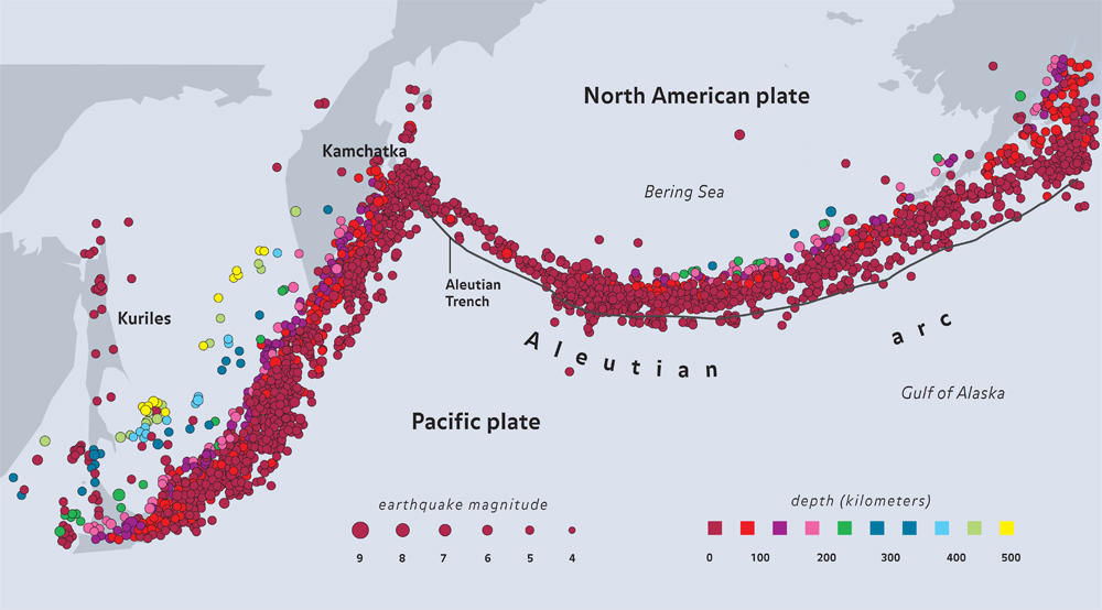
Aleutian Earthquakes
In the last 100 years, the approximately 3,400-kilometer (2112-mile)-long Alaska-Aleutian subduction zone has ruptured with several earthquakes of greater than magnitude about 8 and some of these have spawned tsunamis. The Alaska-Aleutian Trench hosted the second largest earthquake recorded by modern seismic instrumentation in 1964, according to the U.S. Geological Survey Earthquake Hazards Program. The famously devastating, magnitude 9.2 earthquake in 1964 occurred on the subduction zone near Kodiak Island and is known as the “1964 Great Alaska Earthquake.” Not long after, a magnitude 8.7 earthquake in the Rat Islands area struck in 1965.
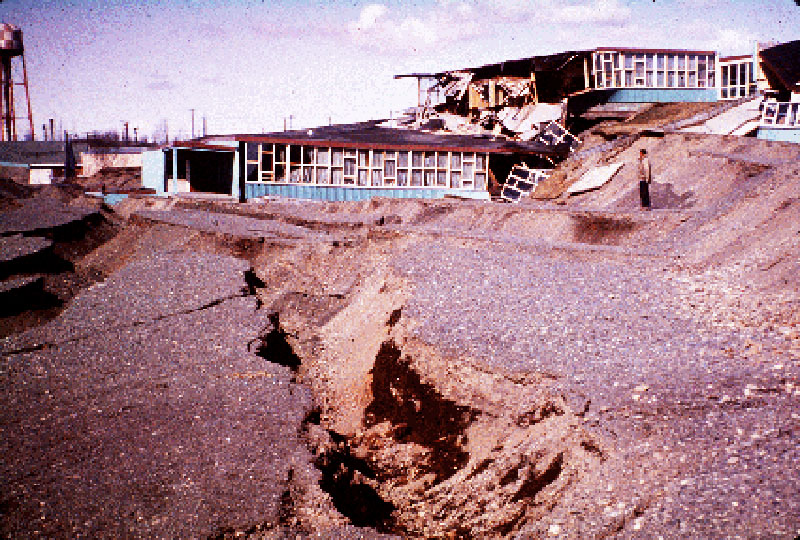
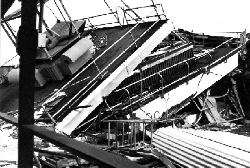
In recent years, a magnitude 7.1 earthquake struck the Anchorage to Matanuska-Susitna area in 2018, causing at least $76 million in damages to homes, businesses, and public facilities (Gardine and Ruppert, 2019). This earthquake was caused by a rupture inside the subducting Pacific Plate 76 kilometers (47 miles) deep (West et al., 2018). On average there are more than 40,000 earthquakes per year in Alaska and many, if not all, are related to the subduction zone (UAF Earthquake Center).
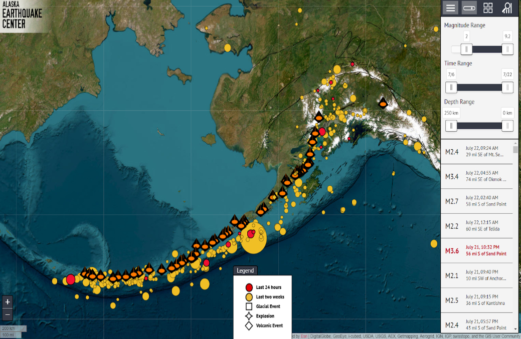
On July 16, 2023, a large magnitude 7.2 earthquake occurred about 98 kilometers (61 miles) south of Sand Point, Alaska, on Unimak Island, triggering tsunami alerts in nearby Kodiak and surrounding areas. The earthquake was reported to be 32.6 kilometers (20.2 miles) deep at the boundary between the subducting plate and overriding plate. NOAA Ship Okeanos Explorer was in transit about 100 miles southeast of the Sand Lake earthquake epicenter, but we did not experience anything on the ship. Ultimately, no tsunami was generated and there was no loss of life or structures.
Aleutian Geohazards
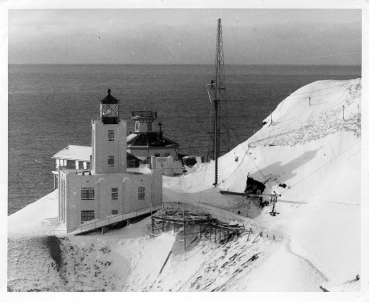
Earthquakes can trigger a range of associated geologic hazards such as tsunamis, landslides, rockfall and avalanches. Plate motion along nearly the entire 4,000-kilometer (2,485-mile) long Aleutian trench has triggered tsunamis (Ramos et al., 2022; Carver and Plaker, 2008). An exceptionally large tsunami occurred in 1946 in the Umniak Island area during an approximately magnitude 8 earthquake offshore. The runup of the tsunami was 42 meters (138 feet) on nearby Scotch Cap where it destroyed a lighthouse and was observed as far south in Antarctica (Witter et. al., 2022).

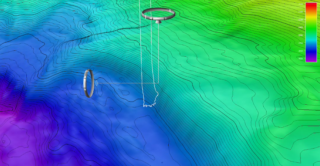
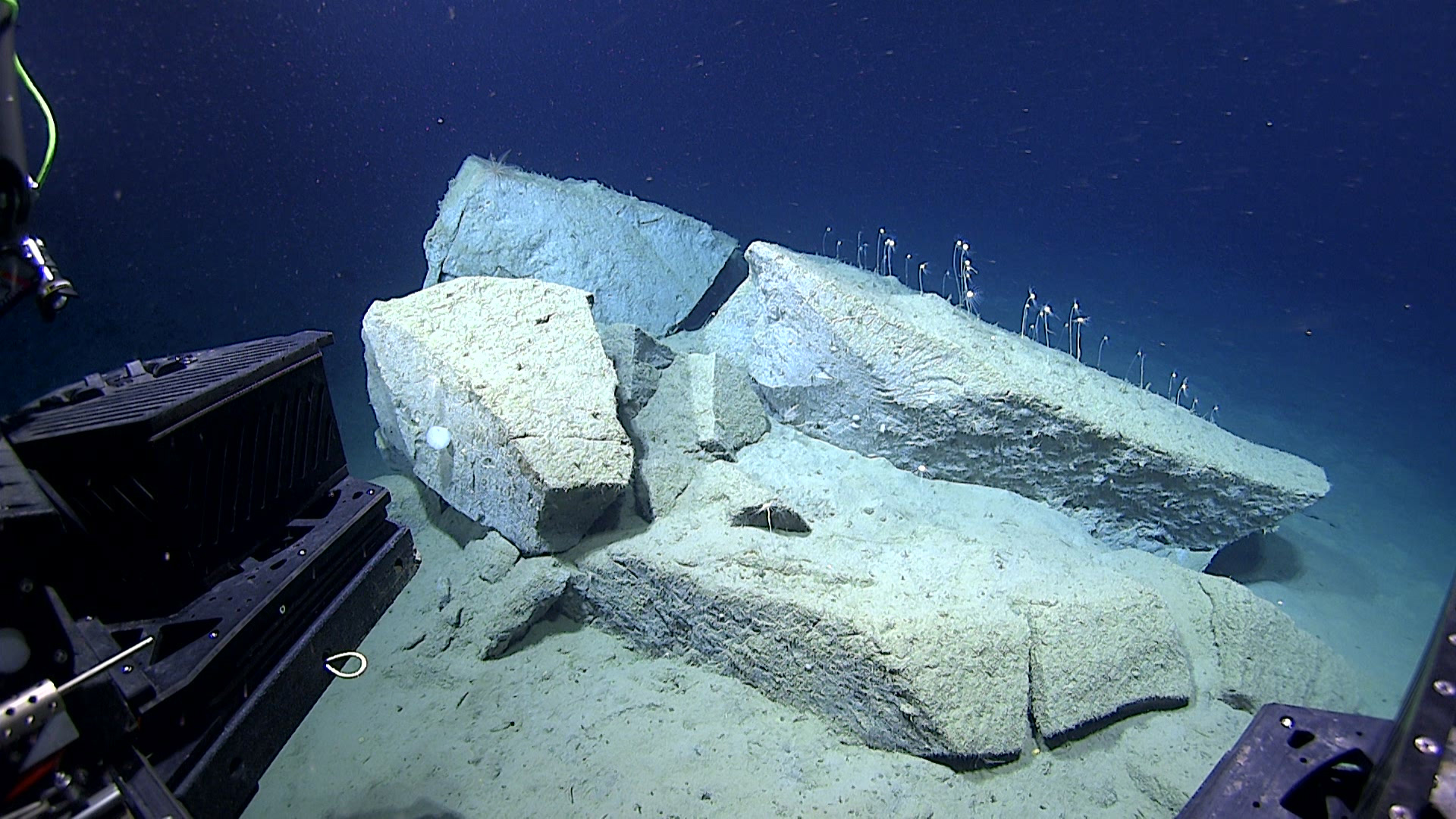
Some geologists have proposed that there was an associated landslide that contributed to the exceptionally high runup of this earthquake. The remnants of the suggested landslide blocks may form Lone Knoll, a prominent feature in bathymetry data offshore of Umniak Island (von Huene et al., 2014). The Seascape Alaska 3 expedition team investigated a landslide scarp with numerous broken blocks on the seafloor north of Lone Knoll to give geologists some insight into whether this scarp was related to the 1946 event.
Aleutian Volcanos
Volcanoes of the Aleutian chain also form as a result of subduction. As the subducting slab moves downward into the Earth it is heated and this leads to dewatering of the subducting slab. This water rises up through the crust and helps to melt the rocks in the overriding plate, forming magma that can form volcanoes. The type and composition of crust that is melted and the amount of water involved controls the type of volcano and eruption style.
Volcanoes in the Aleutian Islands are predominantly steep-sided stratovolcanos that are constructed of volcanic ash, pumice, and lava flows. About 40 of these volcanoes have been historically active. The recent eruption on July 18, 2023, of the Shishaldin Volcano on Unimak Island sent an ash cloud into the atmosphere that ascended to about 9 kilometers (30,000 feet) and triggered aviation warnings (Alaska Volcano Observatory Report History for Shishaldin Volcano). Okeanos Explorer was in transit about 70 miles from this volcano when it erupted.

By Jennifer Aschoff, Ph.D.
Associate Professor of Geology, University of Alaska, Anchorage
Science Lead, Geology Seascape Alaska 3
Published July 25, 2023
Carver, G. and Plafker, G., 2008, Paleoseismicity and Neotectonics of the Aleutian Subduction Zone—An Overview. In Active Tectonics and Seismic Potential of Alaska (eds J.T. Freymueller, P.J. Haeussler, R.L. Wesson and G. Ekström). https://doi.org/10.1029/179GM03
Gardine,L. and Ruppert, N., 2019, UAF Alaska Earthquake Center 2018 Year In Review https://earthquake.alaska.edu/2018-year-review
Michael E. West, Adrian Bender, Matthew Gardine, Lea Gardine, Kara Gately, Peter Haeussler, Wael Hassan, Franz Meyer, Cole Richards, Natalia Ruppert, Carl Tape, John Thornley, Rob Witter; The 30 November 2018 M7.1 Anchorage Earthquake. Seismological Research Letters 2019;; 91 (1): 66–84. doi:https://doi.org/10.1785/0220190176
Ramos, M.D., Liberty, L.M., Haeussler, P.J., and Humphreys, R., 2022, Upper-plate structure and tsunamigenic faults near the Kodiak Islands, Alaska, USA: Geosphere, v. 18, no. 5, p. 1474–1491, https:// doi.org/10.1130/GES02486.1
von Huene, R., S. Kirby, J. Miller, and P. Dartnell, 2014,, The destructive 1946 Unimak near-field tsunami: New evidence for a submarine slide source from reprocessed marine geophysical data, Geophys. Res. Lett., 41, 6811–6818, doi:10.1002/2014GL061759
Witter, R., R. Briggs, T. Dura, S. Engelhart, and A. Nelson, 2022, Seismic sources in the Aleutian cradle of tsunamis, Eos, 103, https://doi.org/10.1029/2022EO220464
Zimmerman, M., Prescott, M.M.,Haeussler, P.J., 2019 Bathymetry and Geomorphology of Shelikof Strait and the Western Gulf of Alaska: Geosciences, v. 9, no. 409 doi:10.3390/geosciences9100409