Date: November 5, 2019
Location: Lat: 30.422117°, Long: -79.226983°
Dive Depth Range: 811 - 829 meters (2,661 - 2,720 feet)
Access Dive Summary and ROV Data

The predatory cutlassfish stays vertical in the water column as it hunts. It uses its pectoral fins to keep itself stable. We observed this individual during Dive 05 of the 2019 Southeastern U.S. Deep-sea Exploration. Check out video of the fish, which is also known as a ribbonfish. Image courtesy of the NOAA Office of Ocean Exploration and Research, 2019 Southeastern U.S. Deep-sea Exploration. Download larger version (jpg, 546 KB).
Today’s dive started off a bit late due to high winds at the dive site. It was the second of two dives on newly mapped mounds off the coast of Florida in the Stetson-Miami Terrace Deepwater Coral Habitat Area of Particular Concern (HAPC) in the Blake Plateau region. These mounds were targeted based on mapping data collected during the first part of this expedition, which suggested the potential for suitable habitat for deep-sea corals and sponges. As part of the HAPC, this site is a priority for resource managers.
, which we encountered during Dive 05 of the 2019 Southeastern U.S. Deep-sea Exploration is just one of the many sponges we saw during this dive.")
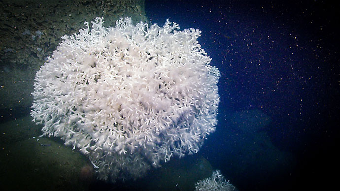
This demosponge (likely a Stylocordyla), which we encountered during Dive 05 of the 2019 Southeastern U.S. Deep-sea Exploration, is just one of the many sponges we saw during this dive. Image courtesy of the NOAA Office of Ocean Exploration and Research, 2019 Southeastern U.S. Deep-sea Exploration. Download larger version (jpg, 1.1 MB).

Seen on Dive 05 of the 2019 Southeastern U.S. Deep-sea Exploration, this pencil sea urchin is a good example of the sea urchins we’ve observed in this region. Image courtesy of the NOAA Office of Ocean Exploration and Research, 2019 Southeastern U.S. Deep-sea Exploration. Download larger version (jpg, 1.3 MB).
As seen on previous dives, the seafloor was covered in coral rubble with mixed sand. At first glance, we didn’t see many signs of life, but when we zoomed in, we found it covered with life, including isopods, hydroids, small crustaceans, and some fan sponges. Most of the top of the mound was standing dead coral.
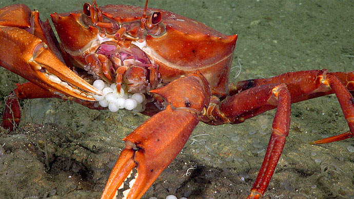
Other animals we encountered today included both 5- and 10-armed feather stars, a pencil sea urchin, a cutlassfish, a decorator crab with a glass sponge on its back, and a sea star feeding on an octocoral. In addition, we saw quite a diversity of sponges, including an interesting glass sponge that was the only sample we collected during this abbreviated dive.

We sampled this interesting “potato chip-like” glass sponge, which was host to a variety of other deep-sea creatures, during Dive 05 of the 2019 Southeastern U.S. Deep-sea Exploration. Image courtesy of the NOAA Office of Ocean Exploration and Research, 2019 Southeastern U.S. Deep-sea Exploration. Download larger version (jpg, 1.1 MB).
On shore, our colleagues from the NOAA National Centers for Environmental Information, the folks who manage all the great data that we collect, gave us a shout out and shared our live stream during the keynote address at the ESRI Ocean and Atmospheric Forum.

Location of Dive 05 of the 2019 Southeastern U.S. Deep-sea Exploration expedition on November 5, 2019. Download larger version (jpg, 2.0 MB).

The remotely operated vehicle track for Dive 05 of the 2019 Southeastern U.S. Deep-sea Exploration expedition, shown as an orange line with a white curtain. This mapping data was collected during the first part of the expedition. Legend shows water depth in meters. Download larger version (jpg, 5.6 MB).