Date: November 3, 2019
Location: Lat: 29.86145°, Long: -79.45865°
Dive Depth Range: 763 - 808 meters (2,503 - 2,651 feet)
Access Dive Summary and ROV Data

This glimpse of the seafloor during Dive 03 of the 2019 Southeastern U.S. Deep-sea Exploration is indicative of the landscape that was seen during much of the dive. Image courtesy of the NOAA Office of Ocean Exploration and Research, 2019 Southeastern U.S. Deep-sea Exploration. Download larger version (jpg, 1.3 MB).
Strong currents and opposing forces from wind and waves forced us to delay today’s dive and modify our original dive plans. Ultimately, we selected a dive site east of the original plan in the middle of the Stetson-Miami Terrace Deepwater Coral Habitat Area of Particular Concern and to the west of the Million Mounds area. These unexplored features were of interest due to their potential to focus subseafloor groundwater seepage, expose faults, and display a biological gradient upslope. By characterizing these features, we will provide valuable information about the geologic makeup and biological communities of these features.
During Dive 03 of the 2019 Southeastern U.S. Deep-sea Exploration, we explored a site within the Stetson-Miami Terrace Deepwater Coral Habitat Area of Particular Concern, to the west of the Million Mounds area. For much of the dive, the seafloor was covered with coral rubble, and we did not see a large number of animals. However, zooming in on features revealed that the area was far from barren, and we were often able to get a glimpse of smaller animals living within the coral rubble. Although they may be hard to see with the naked eye, these animals play an important role in the overall deep-sea ecosystem. Video courtesy of the NOAA Office of Ocean Exploration and Research, 2019 Southeastern U.S. Deep-sea Exploration. Download larger version (mp4, 59.3 MB).
We began the dive in a basin at the base of a ridge on a sandy bottom with coral rubble. The most common species at the base of the ridge was the elephant ear sponge. We also observed yellow sponges and sea urchins, but they were more sparse.
Patches of sandy bottom showed wide ripples indicative of a consistent current flow. At the toe-of-slope of the ridge, we encountered ~1 meter (3.3 feet) tall sand dunes with coral rubble at their peaks and sediment patches on the leeside of the dunes.
 observed during Dive 04 of the 2019 Southeastern U.S. Deep-sea Exploration. These piles form when the front of a sponge absorbs most of the current, enabling the sediments to settle out rather than being swept away by the current.")
Small piles of sand were seen behind the larger elephant ear sponges (Phakellia connexiva) observed during Dive 04 of the 2019 Southeastern U.S. Deep-sea Exploration. These piles form when the front of a sponge absorbs most of the current, enabling the sediments to settle out rather than being swept away by the current. Image courtesy of the NOAA Office of Ocean Exploration and Research, 2019 Southeastern U.S. Deep-sea Exploration. Download larger version (jpg, 1.3 MB).
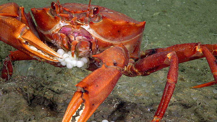
Among the fish we saw at the base of the slope were a cusk-eel, a duckbill eel, a black bellied-rosefish, a Pluto skate, and a few rattails, including a swordsnout grenadier (Coelorinchus occa), which is widespread geographically, but fairly rare.
As we continued up the slope, the patches with sand waves began to disappear and were replaced with coral rubble. We observed fewer animals on the seafloor here, but did see a small yellow sponge, which we collected as a possible new species (our only sample of the dive), some feather stars, a shortnose greeneye, a glass sponge, and a hagfish.
 as it swam along the coral rubble of the seafloor during Dive 03 of the 2019 Southeastern U.S. Deep-sea Ocean Exploration. Look close at its eye and you’ll see how it got its name.")
We observed this shortnose greeneye (Chlorophthalmus sp.) as it swam along the coral rubble of the seafloor during Dive 03 of the 2019 Southeastern U.S. Deep-sea Ocean Exploration. Look close at its eye and you’ll see how it got its name. Image courtesy of the NOAA Office of Ocean Exploration and Research, 2019 Southeastern U.S. Deep-sea Exploration. Download larger version (jpg, 1.5 MB).
Farther up the slope, we saw a slight increase in standing dead coral and exposure of carbonate rock slabs. Species observed included a cookie star, glass sponges, and a variety of corals and their associates. At the top, we saw more standing dead coral, some live coral, elephant ear sponges, and another type of sponge.
 and its numerous associates, including about 30 brittle stars and a squat lobster.")
Toward the end of Dive 03 of the 2019 Southeastern U.S. Deep-sea Exploration, we came across this shingled tree coral (Candidella imbricata) and its numerous associates, including about 30 brittle stars and a squat lobster. Image courtesy of the NOAA Office of Ocean Exploration and Research, 2019 Southeastern U.S. Deep-sea Exploration. Download larger version (jpg, 1.6 MB).

Location of Dive 03 of the 2019 Southeastern U.S. Deep-sea Exploration expedition on November 3, 2019. Download larger version (jpg, 2.0 MB).

The remotely operated vehicle track for Dive 03 of the 2019 Southeastern U.S. Deep-sea Exploration expedition, shown as an orange line with a white curtain. This mapping data was collected during the first part of the expedition. Legend is water depth in meters. Download larger version (jpg, 5.7 MB).