by Daniel Wagner, SEDCI Research Coordinator, JHT Inc. and NOAA National Centers for Coastal Ocean Science
 will operate in 2016-2019. This area corresponds to the jurisdiction of three fishery management councils, including Gulf of Mexico, South Atlantic and Caribbean fishery management councils (GMFMC, SAFMC, CFMC), shown in gray. Areas where deep-sea habitats are protected through fishing restrictions are shown in orange.")
Map showing the geographic regions in which the Southeast Deep Coral Initiative (SEDCI) will operate in 2016-2019. This area corresponds to the jurisdiction of three fishery management councils, including Gulf of Mexico, South Atlantic and Caribbean fishery management councils (GMFMC, SAFMC, CFMC), shown in gray. Areas where deep-sea habitats are protected through fishing restrictions are shown in orange. Image courtesy of Daniel Wagner/NOAA. Download larger version (jpg, 2.6 MB).
In 2016, NOAA launched a new four-year initiative to study deep-sea coral and sponge ecosystems across the Southeast United States, a region that includes the U.S. federal waters of the Gulf of Mexico, South Atlantic Bight, and Caribbean Sea. This multidisciplinary effort, known as the Southeast Deep Coral Initiative (SEDCI), is led by a NOAA team from multiple line offices that work in close collaboration with partners from federal and academic institutions. Funding for SEDCI activities is provided primarily by NOAA through the Deep Sea Coral Research and Technology Program.
SEDCI builds on previous multi-agency and multi-year collaborations that aimed to increase our understanding of the deep sea. Most recently, NOAA completed the Campaign to Address Pacific Monument Science, Technology and Ocean Needs (CAPSTONE), a successful three-year effort to study deep-sea habitats across the central and western Pacific Ocean. Modeled after CAPSTONE in several ways, SEDCI’s overarching goals from the start of the initiative were to support decision making with the best available science and to make datasets publicly available.
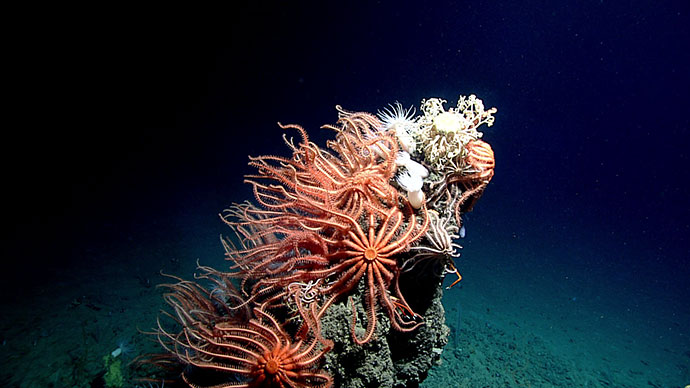
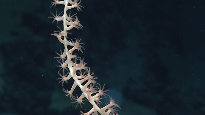
 depth on Elvers Bank in the northwestern Gulf of Mexico. The image was taken during a 2017 SEDCI-supported expedition aboard R/V Manta.")
A dense community of black corals, octocorals, and crinoids at 122 meters (400 feet) depth on Elvers Bank in the northwestern Gulf of Mexico. The image was taken during a 2017 SEDCI-supported expedition aboard R/V Manta. Image courtesy of NOAA-FGBNMS/UNCW-UVP. Download larger version (jpg, 1.5 MB).
The objectives of SEDCI are outlined in its science plan and were developed in consultation with fishery management councils and national marine sanctuaries, as well as partners from Bureau of Ocean and Energy Management, U.S. Geological Survey, and academic institutions. Through this collaborative approach, SEDCI strives to collect scientific information that is most urgently needed by the agencies that manage deep-sea coral ecosystems throughout the Southeast United States.
There are several proposals for the establishment of new managed areas in deep waters of the Southeast United States, including potential new habitat areas of particular concern (HAPC) in the Gulf of Mexico and proposed expansions of the Flower Garden Banks National Marine Sanctuary (FGBNMS), as well as new special management zones in the South Atlantic Bight. Since 2016, SEDCI has been supporting research expeditions to several of these areas, thereby collecting information that is needed to evaluate these proposals. To date, SEDCI has supported expeditions to survey (1) proposed FGBNMS expansion areas aboard R/V Manta, (2) proposed HAPCs on the West Florida Slope aboard NOAA Ship Nancy Foster, and (3) submarine canyons off North Carolina aboard NOAA Ship Pisces.
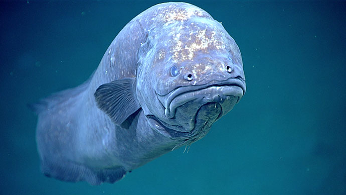
 on the West Florida Slope. The image was taken on a 2017 SEDCI-supported expedition aboard NOAA Ship Nancy Foster.")
Thorny tinselfish, Grammicolepis brachiusculus, swimming above a dense aggregation of Lophelia pertusa and the squat lobster Eumunida picta at 496 meters (1,627 meters) on the West Florida Slope. The image was taken on a 2017 SEDCI-supported expedition aboard NOAA Ship Nancy Foster. Image courtesy of NOAA-FGBNMS/UNCW-UVP. Download larger version (jpg, 1.0 MB).
Collectively, these SEDCI expeditions provided a great amount of new information on deep-sea ecosystems across the Southeast U.S. Region; however, much work remains to be done. For instance, the majority of deep seafloor in this region has not yet been mapped with high-resolution mapping tools, and only a tiny fraction of that area has been surveyed with deepwater submersibles.
This year, NOAA Ship Okeanos Explorer will return to this region to support remotely operated vehicle and mapping operations in the Gulf of Mexico, South Atlantic Bight, and North Atlantic Ocean. These telepresence explorations will not only support SEDCI, but also other collaborative efforts aimed at increasing our understanding of the deep sea, such as the Deep Sea Exploration to Advance Research on Coral, Canyon, Cold seep Habitats (Deep SEARCH) and the Atlantic Seafloor Partnership for Integrated Research and Exploration (ASPIRE).
Given the vast expanses of seafloor areas that remain to be explored, such large collaborations between numerous partners will continue to be essential in order to advance our understanding of deep-sea habitats, which represent the largest portion of our planet.