


NOAA Voyages of Discover
NOAA Voyages of Discovery are designed to convey both the excitement and benefits of ocean exploration into new frontiers with advanced technologies that enable the discovery of ocean secrets previously unknown to humankind. Learn more about the Islands in the Stream/South Atlantic Bight Mission and post questions to the Aquarius aquanauts in the Web Forum.
Background
South Atlantic Bight Region
Oculina Bank Research Reserve
Savannah Scarp
Monitor National Marine Sanctuary
North Carolina Shelf
Charleston Bump
On-line Classroom Activities
Web Forum
Webcast
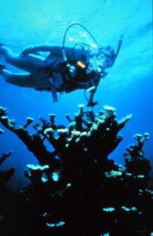
Scuba diving is one way to study coral reefs, yet, as the reefs get deeper, advanced undersea technologies allow us to observe life at deeper depths than people can dive using traditional scuba gear.
Background
Throughout the summer of 2001, the Islands in the Stream (IIS) project has collected information to identify potential Marine Protected Areas (MPAs) and other critical habitats from Belize to North Carolina. The mission uses a variety of technologies -- one-person and multi-person submersibles, remotely operated vehicles (ROVs), acoustic surveys, scuba, etc. -- to explore deep-water coral reef and hard- bottom communities connected by the Loop Current, the Florida Current and the Gulf Stream. Data collection is necessary to compare individual locations and to complement ongoing research efforts occurring at these sites. In addition, the information supports the efforts of the Gulf and South Atlantic fishery management councils to aid in the recovery of overfished stocks, and to ensure healthy fish habitats.
The first two portions of the IIS project, in the Caribbean and Gulf of Mexico, were conducted in partnership with the Sustainable Seas Expeditions (SSE), a five-year collaborative project between the National Geographic Society ![]() and the National Oceanic and Atmospheric Administration (NOAA). Specific efforts included studying whale shark behavior in relationship to snapper and grouper spawning gatherings, collecting data on habitat and species relationships in MPAs on the West Florida Shelf, and conducting habitat characterization surveys in the newly created Tortugas Ecological Reserve. These portions of the expedition successfully concluded in early July 2001.
and the National Oceanic and Atmospheric Administration (NOAA). Specific efforts included studying whale shark behavior in relationship to snapper and grouper spawning gatherings, collecting data on habitat and species relationships in MPAs on the West Florida Shelf, and conducting habitat characterization surveys in the newly created Tortugas Ecological Reserve. These portions of the expedition successfully concluded in early July 2001.
The IIS/South Atlantic Bight Mission is conducted in collaboration with the Harbor Branch Oceanographic Institution (HBOI) ![]() , and employs HBOI's multi-person submersibles Clelia and Johnson-Sea-Link, as well as its oceanographic vessel, the Seward Johnson II. Research will focus on the exploration of deep-water habitats and MPAs.
, and employs HBOI's multi-person submersibles Clelia and Johnson-Sea-Link, as well as its oceanographic vessel, the Seward Johnson II. Research will focus on the exploration of deep-water habitats and MPAs.
The South Atlantic Bight continental shelf, which extends from Cape Hatteras, NC, to Cape Canaveral, FL, is a unique coastal area in many ways. The shelf width varies from 40 to 140 km (25 to 87 mi) in the Bight, with natural reefs comprising about 15 to 20 percent of the bottom. These reefs largely consist of "live bottom" covered with attached algae and marine animals, and support more than 70 percent of the region's offshore pelagic (deep-sea) and reef fisheries. Many of the reefs are land remnants from the distant past, when the climate was colder and sea level was much lower. They now lie in deep water below 50 m (164 ft) and are referred to as "hard bottoms." Exposed hard bottom is necessary to form the important "live bottom" communities, and is more common in deeper water, where the impacts of sediments and runoff are less pronounced. In terms of population and development, the Bight's coastal areas are among the fastest-growing in the nation. The constant pressure to develop unpopulated coastal areas increases the strain on regional resources and may threaten the health of coastal ecosystems. The South Atlantic Fisheries Management Council is holding public hearings to discuss the establishment of marine protected areas (MPAs) in the region, which are designed to restore failing reef fisheries, such as snapper and grouper. Target areas include features such as shelf-edge reefs, areas of high-relief outcrops and pinnacles, and other areas containing unique species and habitats.
The South Atlantic Bight Mission starts off the northern coast of Florida and continues north along the Eastern Seaboard to Cape Hatteras, North Carolina. The mission then turns south again, ending in Charleston, South Carolina, in time for NOAA's Ocean Exploration Days.
The IIS/South Atlantic Bight Mission will continue efforts to explore, characterize, and make connections between physical environments and biological resources in protected and unprotected habitat areas. In addition, this expedition will include a significant cultural component, and will attempt to collect information and samples useful for biomedical research. The expedition will use a variety of technologies, including occupied and unoccupied submersibles, survey instruments, and other equipment to enhance our understanding of the region. Teams of scientists and educators from several different institutions will combine their skills to focus on the mission objectives specific to the areas being visited.
Leg One: Characterizing the Oculina Bank Research Reserve
Oculina Bank, situated 30 km (18 mi) east of the northern Florida coast, was the first deep-water site in federal waters off the U.S. Eastern Seaboard to be closed to fishing. Once, this area was covered with dense thickets of the ivory tree coral, Oculina varicosa, which provided excellent habitat for reef fish, such as grouper and wreckfish, and feeding grounds for migratory pelagic (deep-sea) species. However, fishing activities destroyed approximately two-thirds of the bank. A fragile and slow-growing coral, deep-water Oculina only grows about one-half inch per year. These and other damaged coral reefs will take many years, even decades, to recover. To aid in the recovery process, a significant portion of the area was closed to fishing in 1994. NOAA has since funded efforts to assess the bank and to attempt to restore the damaged areas. In July 2000, the National Marine Fisheries Service approved plans to expand the protected area, with the goal of saving the remaining ivory tree coral. Much of the protected area is deeper than 100 m (328 ft), rugged, and can only be studied using advanced undersea technologies.
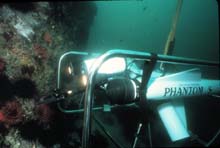
The Phantom ROV (remotely operated vehicle) will be used throughout the IIS/South Atlantic Bight Mission to supplement the submersible work.
Leg Two: Distribution and Abundance of Fish Species at Savannah Scarp
Deep coral banks and areas of rocky outcrops occur all along the continental shelf edge, from northern Florida to Cape Hatteras, at depths of 100 to 500 m (328 to 1,640 ft). These are the most popular fishing grounds for commercial fishers. Many of these banks lie under the Gulf Stream or are routinely bathed by its west wall, eddies and filaments. Preliminary expeditions have explored some of these areas, but in general, we know little about their distributions and associated biology, and especially little about the resident fish populations.
This leg of the mission, led by Gray’s Reef National Marine Sanctuary, will provide useful information for comparing the Savannah Scarp to similar structures occurring within the sanctuary boundaries. For three days in September 2001, the team will explore these outcrops, and assess how they influence the development of coral and hard-bottom communities. The team also will study the combined effects of the habitat and the currents on the distribution and abundance of fish species. This leg will include the first submersible dives ever to take place here.
Leg Three: Submerged Cultural Resources at the Monitor National Marine Sanctuary
The first U.S. National Marine Sanctuary was established 32 km (approx. 20 mi) off Cape Hatteras, NC, at the wreck site of the USS Monitor, a Civil War ironclad vessel. The wreck has deteriorated rapidly in recent years. While the 73-m (240 ft) depth and strong currents make diving difficult at the wreck site, the sanctuary has been working for the past two summers with the U.S. Navy, using sophisticated scuba-diving techniques, to stabilize the wreck and to recover important artifacts. On July 16, 2001, the team recovered the 30-ton steam engine. Leg 3 of the IIS/South Atlantic Bight Mission will be conducted near the site for six days in mid-September 2001, after the scheduled stabilization and recovery work has concluded. Using the HBOI submersible Clelia, marine archeologists will survey the completed work and collect information to help plan next year’s efforts. In addition, this mission will provide an opportunity for supporters of the Monitor National Marine Sanctuary and members of the media to visit the wreck. Specific tasks include collecting digital video of the Monitor and collecting artifacts that may be scattered nearby. You may wish to participate in the Live Web Chat on Preserving Our Cultural Heritage.
Leg Four: The North Carolina Continental Shelft (The Point, Lophelia Reefs, and Cape Fear Terrace
The North Carolina Shelf consists of a wide range of habitats, many of which are rarely, if ever, visited. The existing data, however, indicate that the shelf includes numerous high-relief outcrops, paleo (ancient) reefs and shorelines, and potentially extensive hard-bottom communities, all of which typically support a variety of commercially important and unique fish species. Because the data is scarce, scientists have a limited understanding of the shelf's habitats, species distribution, and ecological function, even though it is heavily used by commercial and recreational fishers as well as commercial shipping traffic. The effects of these activities on shelf habitats are virtually unknown.
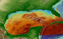
This leg of the IIS/South Atlantic Bight Mission will target three distinct systems. For two days, the HBOI submersible Johnson-Sea-Link will explore a unique continental-shelf canyon system at "The Point." The southernmost Mid-Atlantic canyon system, The Point has distinctive benthic (bottom-dwelling) habitats and fish assemblages, which may be influenced by the unique and ever-changing patterns of currents and gyres there. At this spot, colder, nutrient-laden coastal waters from Virginia flow south along the coast, "bounce" off of Cape Hatteras, and collide with warmer, Gulf Stream waters. The result is a "hot spot" of productivity, from seabirds in the air to plankton and giant bluefin tuna in the sea. Scientists will document conditions from the canyon heads to depths greater than 600 m (1,970 ft).
Next, scientists will spend four days studying the ecology and community structure of fish and macroinvertebrates at the Lophelia Reefs, an extensive system of deep-water corals (Lophelia and Denrophelia) existing below the Gulf Stream. They hope to add to the very limited collections of specimens from the banks, and gain enough information to begin to describe the numbers and types of species, their distributions, and their habitat associations.
This leg will conclude with two days of exploration at the Cape Fear Terrace, an extensive area of hard-bottom communities that may support a well-developed, diverse community of subtropical fish and benthic species. Most of the existing data for this area has been collected for selected fisheries species. The IIS/South Atlantic Bight Mission is one of few ever conducted here that is independent of fisheries. Because time is limited, scientists hope that the data obtained will set the stage for additional work in the future.
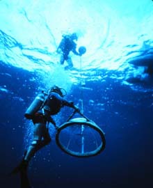
Ocean sampling involves a variety of techniques, some more high-tech than others.
Leg Five: Visual Observations and Biota Samples at Charleston Bump
The Gulf Stream encounters the Charleston Bump at the South Carolina-Georgia border. The Bump is a highly productive ecosystem, in part because it interacts with the Gulf Stream, and is now being considered for marine protected status. The feature is one of the most popular fishing grounds in the South Atlantic Bight, and provides both spawning and nursery habitat for many species. The Bump essentially causes the Gulf Stream to "break up," much like a large rock in a river. Consequently, water upwells to form large, cyclonic eddies and filaments downstream (north) of the Bump. The eddies are a crucial mechanism for the transport of reef fish to shelf environments off the Carolinas.
The IIS/South Atlantic Bight Mission will conclude at the end of September with three days of operations in the vicinity of the Charleston Bump. Scientists will complement visual observations with specimens to understand more about the distribution of juvenile stages of commercially important pelagic species. Oceanographic observations, including CTD (conductivity, temperature, depth) and ADCP (Acoustic Doppler Current Profiler), will help describe this highly dynamic environment.
On-line Classroom Activities
Courtesy of the Bridge  Web site
The "Dead Zone": A Marine Horror Story ![]() October 1999 Data Tip
October 1999 Data Tip
Learn about the cause and implications of the Gulf of Mexico "Dead Zone." Includes maps illustrating the size of the Mississippi River watershed and the Dead Zone. The data provides water-quality measurements, and students can graph dissolved oxygen versus depth. Can you think of potential solutions to the problem?
For the Love of Seafood ![]() October 2000 Data Tip
October 2000 Data Tip
It was once believed that the oceans provided an endless bounty of seafood, but with an increasing world population and more efficient fishing gear, it is now apparent that ocean resources are limited. Take a look at the Monterey Bay Aquarium's Seafood Watch Chart and see which species are in danger of being overfished. Then examine the fisheries management issue from all sides -- that of fishery managers, fishers, and concerned activists.
Tides ![]() August 2000 Data Tip
August 2000 Data Tip
Tides dictate the lives of marine organisms that live within their reach, as well as the plans of people who live, work, and play near the coast. This month, we examine the factors that influence the tides and use NOAA tide data to make tidal predictions.
Catch and Release ![]() January 2000 Data Tip
January 2000 Data Tip
If you think that recreational fishing has little impact on fish stocks, well, think again! This weekend hobby can really add up, but a new breed of anglers are making a difference through "catch-and-release" methods. Find out more about this conservation effort, and plot catch-and-release data from the National Marine Fisheries Service to observe trends.
Coral Bleaching ![]() May 1999 Data Tip
May 1999 Data Tip
Learn why some of the planet's most diverse ecosystems are at risk. Choose a country with reefs that interest you, and do some research using the ReefBase Database. Propose some management recommendations for the country's reefs, and discover 25 things you can do to save coral reefs.
Swordfish on the Decline ![]() February 1999 Data Tip
February 1999 Data Tip
Take a turn in the fisheries management field by examining the reasons for the decline in swordfish stocks, and drafting regulations to help the swordfish recover. Take a look at the commercial fisheries data and plot it in Microsoft Excel using step-by-step instructions.
Classrooms can post questions to the scientists, ocean explorers, and educators-at-sea participating in the Islands in the Stream/South Atlantic Bight Mission. Please enter your name, your school, and your state when you post a question. To ask your questions in the chat room all you need is a connection to the Internet. This text-based interface is easy to use. The moderation feature will ensure that all comments and questions made public are appropriate for students of all ages. Once your questions are posted in the Web forum, they will be answered by the participating mission team. Answers will be posted the following day.
Webcast: Oct. 9, 2001
1:00 - 2:00 PM Eastern (10:00 - 11:00 AM Pacific)
Be sure to ask questions via the Live Web Chat Room during the broadcast, your questions may actually get answered in real-time!
Webcasts are live video and/or audio feeds easily accessed via the Internet. On October 9, 2001, your classroom can interact with the scientists, ocean explorers, and educators-at-sea participating in the Islands in the Stream/South Atlantic Bight Mission. While watching the live video stream or listening to the live audio stream, students can ask questions from within a live, moderated chat room, and possibly have them answered during the program.We will attempt to answer as many questions as possible. Questions not addressed during the hour-long show we will be answered in the chat room shortly following the program.
You will need to download RealPlayer to view and/or hear the live Webcasts. It is advised that you download RealPlayer ![]() (look for free versions) and test it well in advance of the live broadcast. To ask your questions in the chat room all you need is a connection to the Internet. This text-based interface is easy to use. The moderation feature will ensure that all comments and questions made public are appropriate for students of all ages.
(look for free versions) and test it well in advance of the live broadcast. To ask your questions in the chat room all you need is a connection to the Internet. This text-based interface is easy to use. The moderation feature will ensure that all comments and questions made public are appropriate for students of all ages.
Satellite receiving schools: Ku Band SBS-6 Transponder 74
Sign up for the Ocean Explorer E-mail Update List.