


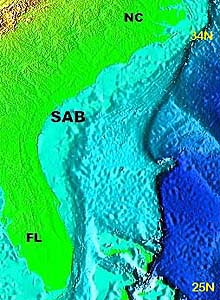
The South Atlantic Bight is the term used to describe the U.S. coastal ocean from North Carolina to the east coast of Florida. Click image for a larger view.
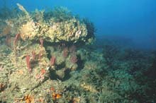
This "live bottom" temperate reef is off the coast of North Carolina. Click image for a larger view.
South Atlantic Bight: Bitten by Worsening Problems
Andrew N. Shepard
National Oceanic and Atmospheric Administration
National Undersea Research Center
The University of North Carolina at Wilmington
A Slight Misnomer
According to some science publications and local wisdom, the South Atlantic Bight (SAB) extends roughly from Cape Hatteras, NC, to West Palm Beach, FL. Actually, the term South Atlantic Bight is not particularly accurate. From a global perspective, the South Atlantic is below the Equator. A bight is defined as a long, gradual bend or recess in the coastline that forms a large, open bay -- which does loosely describe the coastal ocean between North Carolina and Florida. So, if you stick to the U.S. East Coast, SAB is a convenient way to label the region.
The label is also useful because the region has many features that distinguish it from neighboring regions. The SAB continental shelf varies from 40 to 140 km wide. Rock reefs covered with attached algae and animals, or"live bottom," comprises up to 20% of the shelf bottom and supports more than 70% of the offshore fisheries. This is a higher percentage of shelf hard bottom than is found in regions to the north and in the Gulf of Mexico (except for the Florida Keys).
At the same time, a huge salt "river," the Gulf Stream, flows at 4 to 5 knots along the shelf break until it deflects out over the open ocean off Cape Hatteras. A constant succession of massive eddies and upwellings peel off the Gulf Stream's western wall, carrying life from the tropics to the temperate sounds of North Carolina. The continental slope varies dramatically, from the phosphorite rocks and outcrops of the Blake Plateau, to the steep mud canyons of the Upper Hatteras Slope. Compared to neighboring states to the north and in the Gulf of Mexico, the SAB is less developed, yet is still the fastest-growing region on the East Coast. Because there is no nearby major research center specializing in deep-sea research, most of the region is unexplored.
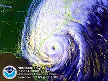
Hurricane Floyd flooded one-third of Coastal Carolina, causing billions of dollars in damage. Click image for a larger view.
A schematic drawing of the electrophysiology apparatus used to study the color and light sensitivity of deep sea benthic organisms.
The Need for Research
Ocean research is critically needed in the SAB region. Not only is it experiencing the largest coastal population growth rate in the country, the region is also plagued by frequent major storm events and flooding, and the forecast for the coming years is worse. Industrial and agricultural pollution is on the rise. The number of aquatic toxic microbial outbreaks and harmful algal blooms are increasing. The development and paving of coastal lands is hastening the introduction of pollutants to watersheds and their ultimate destination, the coastal ocean.
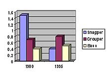
At the same time, fishery harvests are declining for many commercially important species in the SAB. Commercial landings of red snapper exhibited an almost uninterrupted decline from about 14 million pounds in 1965 to 2.7 million pounds in 1990, the last year before quotas were
imposed. Snapper landings in North Carolina declined from more than 1.5 million lbs in 1980 to 0.4 million lbs in 1995 (see chart, left). The South Atlantic Fishery Management Council ![]() (also misnamed for the same region north of the Equator) is now hosting public hearings on the use of marine protected areas to restore fish populations and habitat. Many of the proposed target areas are offshore “live bottom” reefs. The deep reefs, especially those that lie beneath the Gulf Stream, are difficult to reach and study. The Islands in the Stream expedition will add to our limited knowledge of some of the more dramatic and important reef and pelagic fish habitats in the SAB.
(also misnamed for the same region north of the Equator) is now hosting public hearings on the use of marine protected areas to restore fish populations and habitat. Many of the proposed target areas are offshore “live bottom” reefs. The deep reefs, especially those that lie beneath the Gulf Stream, are difficult to reach and study. The Islands in the Stream expedition will add to our limited knowledge of some of the more dramatic and important reef and pelagic fish habitats in the SAB.
Sign up for the Ocean Explorer E-mail Update List.