


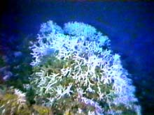
While some areas of the oceans are featureless plains, other areas are rich with colorful undersea life, such as this coral head in the Oculina Research Reserve off Florida. Click image for larger view.
What’s in a Name? Bumps, Bights, Scarps and Shelves
Steve Gittings, Research Coordinator
U.S. National Marine Sanctuary System
NOAA
You may have seen an old cartoon that shows some elderly ladies sitting around a coffee table chatting, and one says to the other with a deadpan look, “I don’t know why I don’t care about what lives on the bottom of the ocean, but I don’t.”
Well, in some ways you can’t blame her. At first glance, the ocean bottom is largely a featureless plain. I was once on a five-day survey on the Navy’s NR-1 research submarine. Lying on my stomach in a tiny, cushion-covered room below the bridge, looking out portholes for 12 hrs a day, the sub crossed mile after mile of soft sediment and an occasional burrow. Animals are there, to be sure, but most are so small that they live between sediment grains. These miniatures may see their muddy home as a high rise with an ocean view. I saw, well, mud.
So why look?
Well, that cartoon lady might be surprised to take a second look at what scientists are finding these days in Earth’s oceans. Far from featureless, if you know where to look, or at least look long enough, you will find nature’s weird and wonderful. I like to say it is a place where the unpredictable is commonplace.
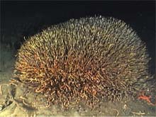
Tubeworm colonies are associated with hydrocarbon and brine seeps in deep-water areas of the Gulf of Mexico, and occur in the deeper waters surrounding the Pinnacles. Click image for larger view.
It seems everywhere we look we are finding new forms of beings with imaginative life-styles. Hydrothermal vents along undersea volcanic ridges are populated by vestimentiferan tubeworms harboring bacteria that use chemical energy from hydrogen sulfide instead of sunlight to make food for their host. Bacteria inside bivalves around natural oil seeps in the ocean derive energy from methane for survival. Mussels with sulfide-utilizing bacteria live at depths of 2,000 ft above pools of water seven times saltier than normal seawater.
A New Look at the Ocean
It was with great expectation, then, that the idea for the Islands in the Stream Expedition was born. Starting in Belize, circling the Gulf of Mexico, then heading up the U.S. Atlantic Coast, this mission would stop at places thought to harbor some of the most diverse and productive environments anywhere. We would document this wealth of life, and compare what we found throughout the journey. We would also try to understand how important processes in the ocean affected their development. Who were the predators and who was the prey? Who preferred what kind of habitat? Where would ocean currents carry larvae? (see The Islands)
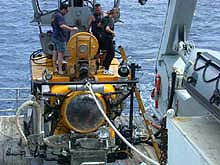
The Clelia is one of the submersibles being used to explore the "islands" of the southeastern Atlantic. Click image for larger view.
There would be several segments, or "legs," of this mission, each with a different science crew. One group would study Belize, another Mexico, a third the Flower Garden Banks in the northwest Gulf of Mexico, a fourth the northeastern Gulf, and a fifth the southeast Gulf. Later in the year, there would be groups studying the Oculina Reserve off Florida, the Savannah Scarp off Georgia, the Charleston Bump, and the North Carolina Shelf (The Point, Lophelia Reefs, Cape Fear Terrace). Each, however, would be looking at things like bottom and fish community development, and human influences on these communities.
The Ivory Tower of Babel
Science is a field full of jargon. I am the first to admit that I don’t even understand the titles in some science articles. You have your immunoreceptors, buckminsterfullerines, restriction fragment length polymorphisms, Euclidean 3-manifolds, photonic atoms, and apoptosis. (Of course, you already know what vestimentiferans are.)
In order to do the work of the Islands in the Stream Expedition, it would be necessary to use a common language. We started with English. Beyond that, it was a challenge. There are countless ways to describe ecological principles and environmental observations. We needed to settle on a scheme that would allow us to compare areas hundreds of miles apart being investigated by people who hardly knew each other.
Toward a Common Language
One way to do this is to standardize how the areas would be evaluated, helping to put the whole region in perspective. There are many characterization schemes. Geologists are particularly adept at describing features, which would be an important aspect of the Islands mission. We would be visiting places with names that reflected their geologic nature -- the Flower Garden Banks, Pulley’s Ridge, the Pinnacles, and Gray’s Reef. All have different geologic descriptors. But how different are they? And is it their geology that distinguishes them, or some other aspect of their environment? To answer these and other questions, we needed a scheme that provided for a broad and comprehensive understanding of the places we visited. We also needed to provide a tool to observers with highly varying levels of training in biology and ecology.
During 2001, a habitat characterization protocol was developed and used on the Caribbean and Gulf of Mexico legs of the mission. The protocol will again be used on the South Atlantic Bight leg. A portion of that scheme is presented here to give you an idea of the type of information and level of detail required.
Protocol for Habitat Characterization
Habitat descriptions at a number of sites visited during the Islands in the Stream mission were based on a combination of exploratory, or reconnaissance, dives, using one-person DeepWorker submersibles, and relatively simple transect and roving surveys conducted using ROVs (remotely operated vehicles), and, where practical, scuba divers. Standardized data forms recorded the activities. At locations targeted for habitat characterization during the expedition, the task is accomplished in several steps, as follows:
- Initial classification of features -- available maps and other types of information were used to choose and prioritize target sites.
- Preliminary reconnaissance -- dives started with a “get-acquainted” session, where pilots recorded the variety and boundaries of habitats within target areas. After becoming familiar with the site, they could begin more detailed assessments.
- Fish community survey -- fish are fundamentally important to ecosystem health, and pilots characterized the community by recording the species they saw, the habitats in which they occurred, and some measure of their abundance (either a relative or absolute abundance).
- Benthic (bottom) video transects -- Pilots used video cameras to record animals and plants living on the bottom. The records were supplemented by extensive verbal descriptions of each habitat. Transects were generally of a predetermined length (usually around 25 m), and organisms were counted later by experts reviewing the videotape.
- Benthic video and audio reconnaissance and sampling -- after completing other tasks, pilots supplemented the data by audio and video recordings of various aspects of each habitat, including species composition, community development, species interactions, species/habitat associations, noteworthy behaviors, and human impacts.
For a more complete description of any of these topics, click here.
Protocols like this enable consistent observations of each of the places visited during the expedition. Without it, comparisons are very difficult to make, and meaningful application of the information to resource management is unlikely to occur. With it, scientists and managers can determine the condition of the sites as well as the threats, and judge the best ways to respond to problems. Some of the management options may include: (1) establishing protected areas to control human activities, such as destructive fishing practices or collecting for other purposes, (2) changing laws related to activities that affect water quality, or (3) altering local plans for responding to spills or other events that might affect particularly sensitive areas. In addressing these information needs, resource mangers are much more capable of ensuring the long-term survival of critical marine ecosystems.
Sign up for the Ocean Explorer E-mail Update List.