

NOAA Ocean Exploration in the Field: 2025
NOAA Ocean Exploration works with partners to explore previously unknown areas of our ocean, making discoveries of scientific, economic, and cultural value and supporting innovations in exploration tools and capabilities. In 2025, NOAA Ocean Exploration will lead and support expeditions and fieldwork in the North and South Pacific oceans and Lake Michigan. Read on to learn more about what we have planned for this year and check back often as we add summaries highlighting major accomplishments and other content from each project.
Dates are subject to change.
NOAA Ocean Exploration conducts ocean exploration expeditions on NOAA Ship Okeanos Explorer, the only federal vessel dedicated to exploring our largely unknown ocean for the purpose of discovery and the advancement of knowledge about the deep ocean.
NOAA Ocean Exploration provides support to the NOAA Ocean Exploration Cooperative Institute to explore, map, and characterize the nation’s vast ocean territory, to develop and implement new technologies, and to engage future generations of ocean scientists, engineers, and stakeholders.
NOAA Ocean Exploration manages an annual ocean exploration competitive grant program to catalyze the ocean exploration community and advance ocean knowledge and collaborates with other NOAA labs and programs to jointly explore the unknown ocean.
NOAA Ocean Exploration provides support for projects as directed by Congress.
This expedition is expected to feature live video of remotely operated vehicle dives.
Expeditions and fieldwork led or supported by NOAA Ocean Exploration in 2025 are described below; click on a title to expand the text and learn more.

March 17-27, 2025
Live Video
NOAA Ocean Exploration’s 2025 field operations on NOAA Ship Okeanos Explorer will commence with an expedition off of Hawai‘i to shake down the ship’s remotely operated vehicle (ROV) and mapping systems. The team will conduct rigorous tests to make sure that ROVs Deep Discoverer and Seirios along with the ship’s mapping, telepresence, and other systems needed to conduct scientific activities are ready to go for the remainder of the year. The shakedown will also provide an opportunity to train staff while ensuring that collected data are of the highest quality.
Learn more
April 8-May 5, 2025
Live Video
NOAA Ocean Exploration will lead a remotely operated vehicle (ROV) and mapping expedition on NOAA Ship Okeanos Explorer to explore deep waters in and around Papahānaumokuākea Marine National Monument, building off three mapping expeditions within the monument in 2024. This expedition will include daytime ROV dives to explore the seafloor and water column, overnight mapping operations, and continuous shoreside participation via telepresence. The expedition is part of Beyond the Blue: Illuminating the Pacific, a multifaceted science campaign designed to raise collective knowledge, understanding, and appreciation of waters in the Pacific Islands region through coordinated mapping and exploration expeditions, data management and sharing, strategic partnerships, and outreach and engagement.
Learn more
April 26-May 3, 2025
NOAA Ocean Exploration supports Ocean Exploration Trust’s operations on Exploration Vessel (E/V) Nautilus via the NOAA Ocean Exploration Cooperative Institute to collaboratively advance marine technologies and reduce uncertainties in critical parts of our largely unexplored deep ocean. This shakedown expedition will ensure systems are ready for the 2025 field season. Information about the field season on E/V Nautilus is on Nautilus Live.

May 7-29, 2025
Live Video
Exploration Vessel (E/V) Nautilus will map and explore deep-sea priority areas around the Mariana Islands, one of the most tectonically and volcanically dynamic locations on the planet. Live video from remotely operated vehicle dives will be streamed for public viewing. NOAA Ocean Exploration supports expeditions on E/V Nautilus via the NOAA Ocean Exploration Cooperative Institute. This expedition is part of the Beyond the Blue: Illuminating the Pacific campaign.
Learn more
June 2-28, 2025
Live Video
Exploration Vessel (E/V) Nautilus will continue to map and explore deep-sea priority areas around the Mariana Islands. These waters include many unique habitats, including the deepest ocean areas and the largest mud volcanoes on Earth. Live video from remotely operated vehicle dives will be streamed for public viewing. NOAA Ocean Exploration supports expeditions on E/V Nautilus via the NOAA Ocean Exploration Cooperative Institute. This expedition is part of the Beyond the Blue: Illuminating the Pacific campaign.
Learn more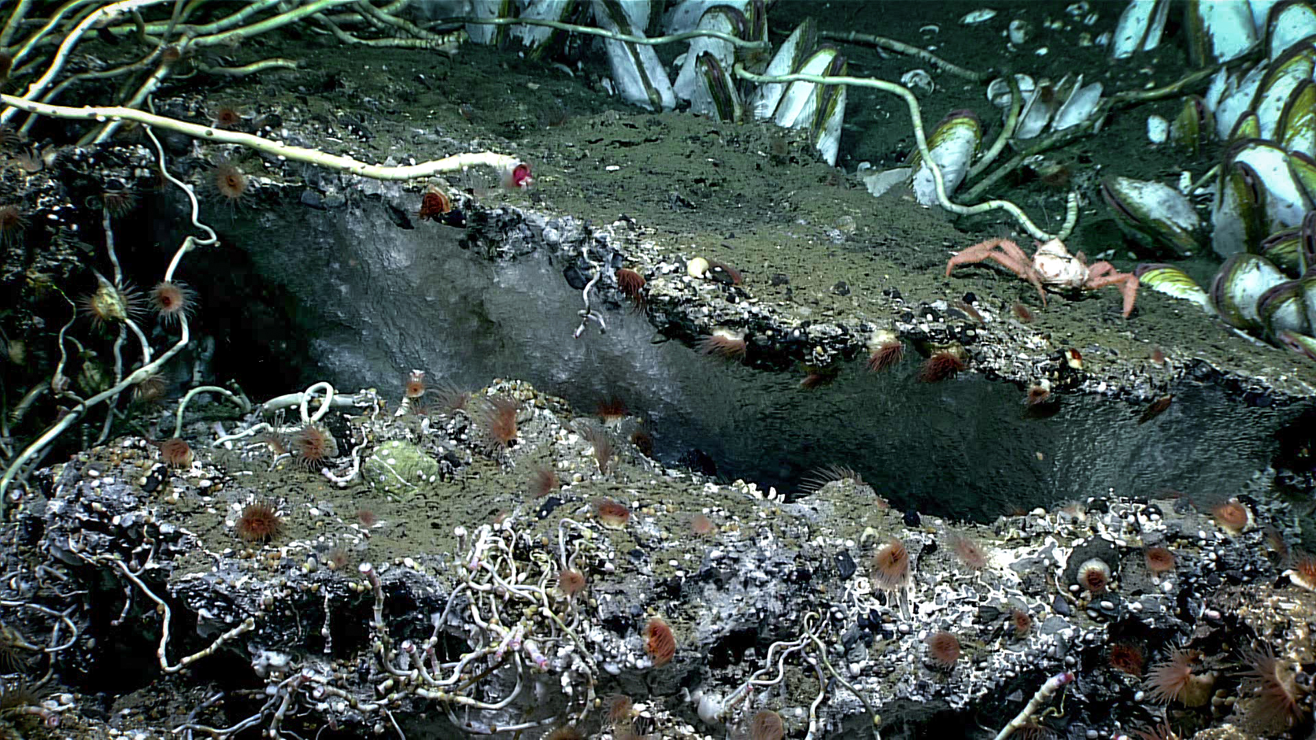
June 15-July 2, 2025
Principal Investigator: Amanda Demopoulos, U.S. Geological Survey
The Aleutian Arc is a volcanic arc that includes a chain of islands extending west from the Alaska Peninsula to international waters. The waters surrounding the Aleutian Islands are vast, and the biological and geological resources within them are ecologically and economically important. But, as of January 2025, only 38% of Alaska’s seafloor has been mapped, and even less has been explored. Much of the deep Aleutian Arc is virtually unknown. To advance our scientific knowledge about this region, where the potential for new discoveries is high, this research team will explore and provide initial characterization of high-priority sites in the central and western Aleutian Islands during a ship- and submersible-based expedition. Research targets for exploration and characterization include coral and sponge communities, volcanoes and other seafloor hazards, gas seeps, hydrothermal vents, and critical mineral deposits. Primary operations will include data collection (e.g., video and biological, geological, and water samples) during submersible dives and seafloor mapping. Results from this expedition will inform natural resource management, protection, and stewardship and hazard assessments, benefitting both Alaskan and national economies as well as human health and safety.
This project is also supported by the Office of Naval Research through the National Oceanographic Partnership Program, the Bureau of Ocean Energy Management, and NOAA Integrated Ocean and Coastal Mapping.
Learn more
June 20-July 16, 2025
After completing work in Hawaiian waters, NOAA Ship Okeanos Explorer will transit to Koror, Palau, setting the stage for NOAA Ocean Exploration and partner operations in the region for much of the remaining calendar year. During the transit, the team will conduct mapping operations, filling gaps in seafloor mapping data along the way in support of the Beyond the Blue: Illuminating the Pacific campaign.
June 30-July 3, 2025 (Second of two expeditions)
Principal Investigator: Oliver Kroemer, Carnegie Mellon University
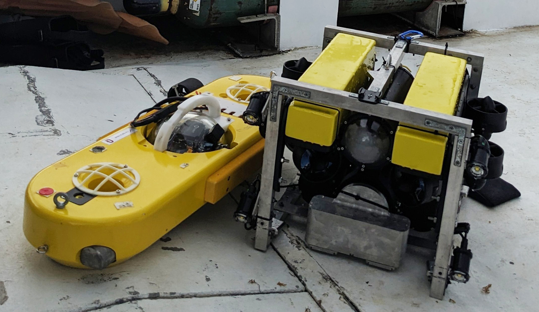
Deep-sea corals provide habitat for a wide variety of marine life. Despite their importance to the environment, little is known about them and the threats to their survival. To help advance the protection of deep-sea coral ecosystems, this team will improve and validate new, low-cost, open-source, autonomous underwater vehicles (AUVs) and develop automatic annotation software. This year, they will test the AUVs and collect data at a site in Hawaiian waters that is known for its high diversity and density of corals. Data collected will be used to generate photometric 3D reconstructions of the seafloor and for the development of the software.
Learn more
July 2-23, 2025
Live Video
Exploration Vessel (E/V) Nautilus will explore maritime heritage sites in the Solomon Islands’ Iron Bottom Sound, where five major naval battles occurred between August and December 1942. Numerous U.S., Japanese, Australian, and New Zealand military ships remain to be located. Live video from remotely operated vehicle dives will be streamed for public viewing. NOAA Ocean Exploration supports expeditions on E/V Nautilus via the NOAA Ocean Exploration Cooperative Institute. This expedition is part of the Beyond the Blue: Illuminating the Pacific campaign.
Learn more
July 22-August 11, 2025; August 18-September 11; September 19-October 8, 2025
NOAA Ocean Exploration and partners will conduct three mapping expeditions on NOAA Ship Okeanos Explorer in waters off Palau. The work will build off expeditions led by Ocean Exploration Trust on Exploration Vessel Nautilus in Palau in 2024. The expeditions will be integral components of the Beyond the Blue: Illuminating the Pacific campaign to increase understanding and appreciation of waters in the Pacific Islands region.
Learn more
July 27-August 18, 2025
Live Video
Exploration Vessel (E/V) Nautilus will map and explore deep-sea priority areas around the Republic of the Marshall Islands, the vast majority of which has never been mapped or surveyed. Features of interest include unexplored seamounts, ridges and escarpments, and World War II maritime heritage sites. Live video from remotely operated vehicle dives will be streamed for public viewing. NOAA Ocean Exploration supports expeditions on E/V Nautilus via the NOAA Ocean Exploration Cooperative Institute. This expedition is part of the Beyond the Blue: Illuminating the Pacific campaign.
Learn more
August 2-12, 2025
Principal Investigator: Russ Green, Wisconsin Shipwreck Coast National Marine Sanctuary
Well preserved by cold freshwater, the Great Lakes possess some of the most extraordinary potential for archaeological investigation of historic shipwrecks anywhere in the world. Many of these shipwrecks have yet to be discovered or explored. This research team will explore and document a collection of nationally significant shipwrecks — 5 unknown and 10 known but minimally documented — in the deep waters (130-480 feet) of Lake Michigan’s Wisconsin Shipwreck Coast National Marine Sanctuary. They will conduct their investigations using a hybrid autonomous underwater vehicle/remotely operated vehicle (AUV/ROV) equipped with acoustic, imaging, and laser scanning sensors, and develop new archaeological methods developed to capitalize on the efficiencies of autonomous and uncrewed vehicles. This project will result in baseline data and information — including still and video imagery and photogrammetric and laser-scan models — that will inform the sanctuary’s monitoring and preservation efforts and contribute to the understanding of the role of the Great Lakes in our nation’s maritime heritage. In addition, it will advance the field of marine archaeology by introducing a new approach that accelerates the exploration, documentation, and management of collections of maritime heritage sites.
Learn more
August 17-September 1, 2025
Principal Investigator: Guangyu Xu, University of Washington
Hydrothermal vents often feature a variety of unique biological communities and metal-rich deposits, making them important to society and economies. However, most hydrothermal vent sites discovered to date are on the deep-ocean floor at great depths below the sea surface. Because of the inherent difficulties of deep-sea exploration and the inadequacy of existing vent-characterization techniques, the majority of the known hydrothermal-vent fields remain poorly studied and many sites are yet to be discovered. To advance our knowledge about hydrothermal vents, this research team will develop an innovative approach to identifying, locating, and characterizing hydrothermal discharge using uncrewed underwater vehicles equipped with coordinated multibeam sonars. After a robust evaluation program, which will include computer simulations and laboratory experiments at an engineering tank facility, the new approach will be demonstrated at an active hydrothermal vent site. Anticipated outputs include seafloor bathymetry, 3D acoustic plume images, quantitative vent maps, and 3D panoramic images of vent sites. By extending the capabilities of uncrewed vehicles, this project will deliver an efficient approach to collecting comprehensive baseline data about hydrothermal activity needed by researchers and policy makers.
Learn more
August 20-September 10, 2025
Exploration Vessel (E/V) Nautilus will map the waters surrounding Wake Atoll, one of the most poorly surveyed ocean areas under U.S. jurisdiction. Data will support the management of the Pacific Islands Heritage Marine National Monument. NOAA Ocean Exploration supports expeditions on E/V Nautilus via the NOAA Ocean Exploration Cooperative Institute. This expedition is part of the Beyond the Blue: Illuminating the Pacific campaign.
Learn more
October 1-21, 2025
Live Video
For the final expedition of 2025, Exploration Vessel (E/V) Nautilus will map and explore priority deep waters around the Cook Islands, one of the most geologically and biologically significant ocean areas in the Pacific. Features of interest include abyssal plains, seamounts, and volcanic ridges. Live video from remotely operated vehicle dives will be streamed for public viewing. NOAA Ocean Exploration supports expeditions on E/V Nautilus via the NOAA Ocean Exploration Cooperative Institute. This expedition is part of the Beyond the Blue: Illuminating the Pacific campaign.
Fall 2025
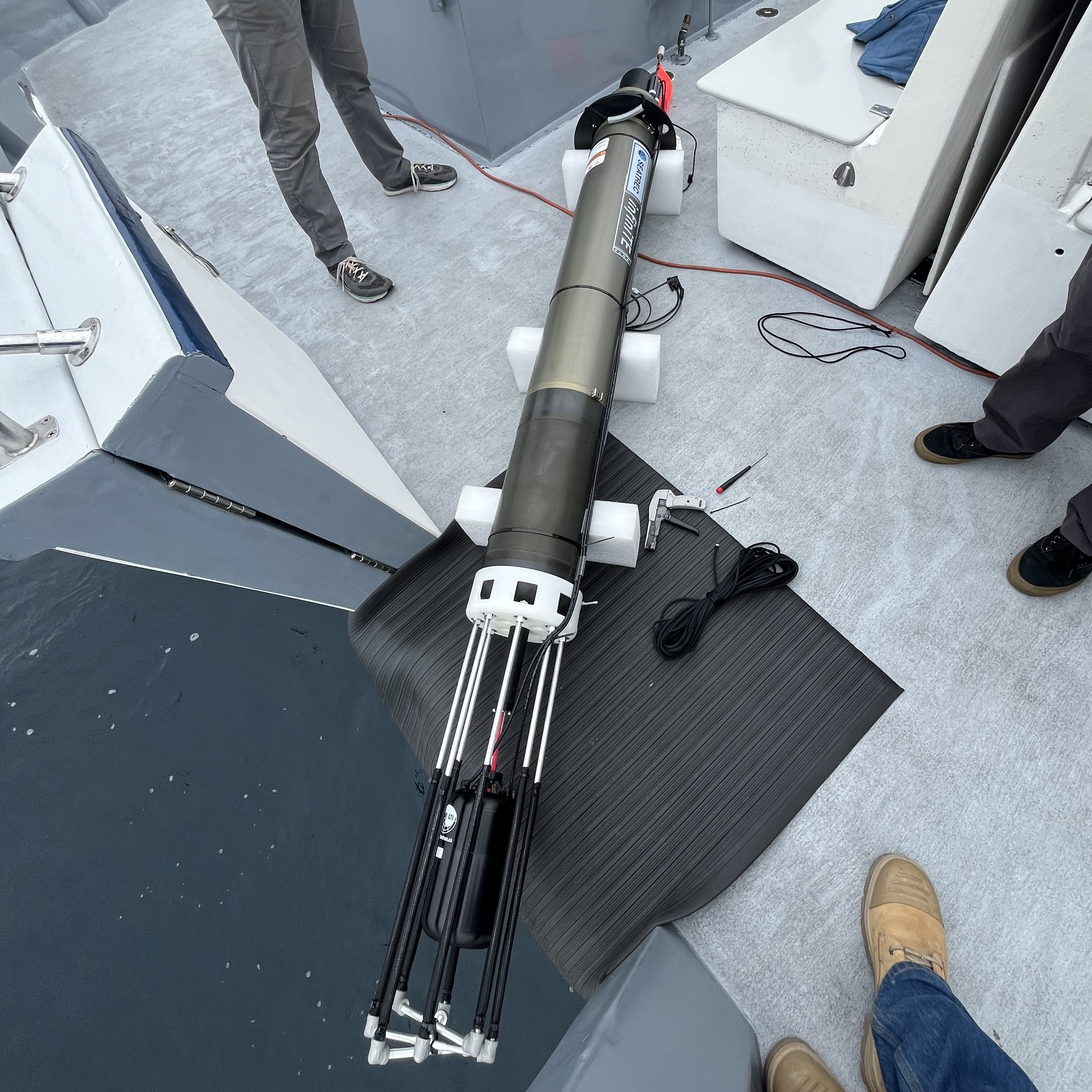
Principal Investigator: Kaustubha Raghukumar, Integral Consulting Inc.
To advance deepwater soundscape exploration, this team of scientists and engineers is developing the first ever autonomous, near-real-time, directional acoustic profiling float powered by marine renewable energy (ocean thermal energy conversion, OTEC). During this second year of fieldwork, they will demonstrate their float during a longer duration and deeper water test off the coast of Oceanside, California. Also as part of this project, the team will develop soundscape analysis tools to provide insights into acoustic events of interest recorded by the float.
Learn more
October 22-23, 2024; January 22, 2025; July 7-11, 2025
Principal Investigator: Kakani Katija, Principal Engineer, MBARI (Monterey Bay Aquarium Research Institute)
We still have much to learn about our ocean and the animals that live within it. Modern robotics, low-cost observation platforms, and other emerging exploration tools are making underwater imaging easier and more accessible. However, processing all this visual data, particularly data with complex scenes and animals that require expert classifications, is quite resource intensive. This research team will use artificial intelligence (AI) to address this significant obstacle to discovery. Specifically, they will develop software for remotely operated and autonomous underwater vehicles to detect, track, and classify seafloor and water column animals in underwater video in real time. They will train this “deployable AI” using FathomNet, a publicly available underwater image training set, which they will expand and augment as part of this project, and test it in the waters of Monterey Bay National Marine Sanctuary. By automating the collection and real-time analysis of large volumes of underwater visual data by uncrewed underwater vehicles and making the imagery available in a global database, this project will enable scientists, policymakers, and the public to better, and more rapidly, understand the life that inhabits our ocean.
Learn more
Last updated January 7, 2026
Published April 10, 2025