by Toni L. Carrell, Ph.D., Chief Scientist and Principal Investigator, Ships of Exploration and Discovery Research
The goals of this project were to locate the scattered material remains of Peleliu’s submerged battlefield, to photogrammetrically record those remains, and to survey the reef to determine if the scars from the UDT mission to blow access ramps into the lagoon were still visible after 73 years.
Because of the environmental characteristics of the invasion beach (deep water quickly rising to a breaking reef and an average of 550 yards of very shallow rocky lagoon leading to a thin sandy beach underlain with broken limestone), we broke the search into four zones:
In each location, we faced some challenges, including large fluctuations in tidal range and longshore current, sometimes helping and other times hindering our search. The heavily overgrown shore made locating defensive positions a challenge. Nonetheless, we successfully examined all of the areas; located several previously unreported sites; and documented sites with photography, 3D photogrammetry, or drone imagery.

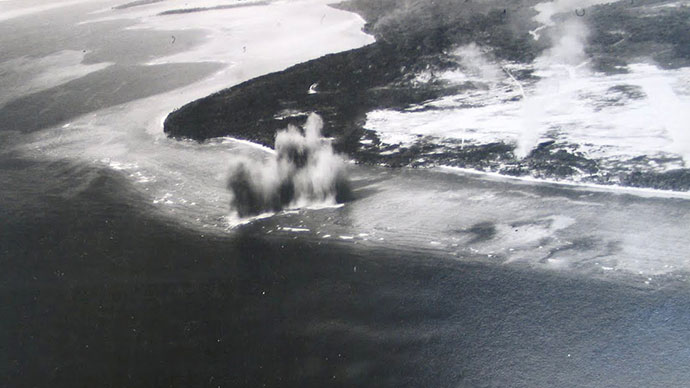
A section of the southern invasion beach with the historic UDT blast zones map overlaying a modern aerial. Two of the blast zones are at the top. Immediately after the invasion, the Seabees extensively modified a shallow coral flat and created a small harbor. Image courtesy of the Ships of Discovery Science Team. Download larger version (3.8 MB).
Our trepidation over identifying the locations of UDT blasting were quickly pushed aside on the first day of diving. Georectifying the original UDT maps over current aerials, we tentatively selected several areas to examine. The results could not have been more dramatic. The pristine reef suddenly gave way to rocks, small boulders, and rubble, only to pop up again on the other side of the blasted channel. The biological characterization exceeded our best expectations.

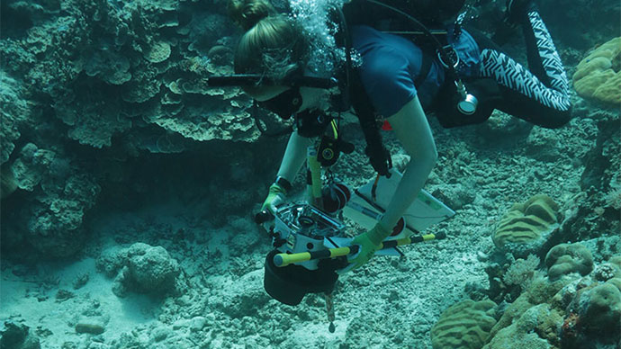
Kailey Pascoe documenting a narrow blast channel between two undamaged areas. Image courtesy of John Burns/Ships of Discovery Science Team. Download larger version (5.2 MB).
According to our coral reef team, the types of corals present on the blast margins today are more hearty than those found at a similar depth in the non-blasted zones. Further, these areas are unlikely to recover in the future because of the dramatic change in the underlying geomorphology of the reef. This is the first time that the UDT blast zones were identified and characterized, but it is unlikely the last effort to document those impacts in the Pacific theater.

The edge of the reef suddenly drops off to a rock and rubble filled channel. Image courtesy of Kailey Pascoe/Ships of Discovery Science Team. Download larger version (jpg, 14.3 MB).

Corals that are more robust predominate in the blast zone. Image courtesy of Kailey Pascoe/Ships of Discovery Science Team. Download larger version (jpg, 5.9 MB).
-4 dumped offshore of Camp Beck.")
Three-dimensional image of an LVT (A)-4 dumped offshore of Camp Beck. Image courtesy of John Burns/Kailey Pascoe/Ships of Discovery Science Team. Download larger version (523 KB).
Among our finds was that a locally well-known LVT site is not a primary deposition of a single vehicle, but more likely a dumpsite with the remains of three vehicles. The sites are heavily coral encrusted and extremely well camouflaged, attesting to the health of the reefs in general and a stark contrast to the UDT blast zones.
We also located the reasonably intact remains of a bulldozer, still with its blade, in about 10 feet of water. Immediately following the invasion, the Seabees used bulldozers to clear the beaches of debris, disabled LVTs, and upended DUKWs (amphibious trucks) before setting to work on rebuilding the airfield.

Bulldozers on the Peleliu shoreline after the successful capture of the southern beaches. Image courtesy of the Seabee Historical Museum. Download larger version (156 KB).

Nearly intact bulldozer off Orange beach. View is from the right rear. Image courtesy of Jennifer McKinnon/Ships of Discovery Science Team. Download larger version (7.4 MB).
As luck would have it, an unusual storm in October 2017 eroded areas of the landing beaches, exposing some material that was partially or completely buried. We identified everything from the tracks of a Sherman tank, wheels and axels to DUKWs, a possible LCM3 (Landing Craft, Mechanized model 3), to the remains of a U.S. aircraft in the lagoon.

Tracks from a Sherman tank exposed at low tide. Image courtesy of Toni Carrell/Ships of Discovery Science Team. Download larger version (jpg, 8.1 MB).

Wheel rims and axels from a DUKW exposed during low tide. Image courtesy of Toni Carrell/Ships of Discovery Science Team. Download larger version (jpg, 7.6 MB).

Drawing of DUKW from U.S. Army Service Manual. Note the dual rear wheels. Image courtesy of ww2db.com. Download image (92 KB).

Aerial view of a possible LCM in the shallow lagoon off the Orange Beaches. The nearly 13-meter by 4-meter remains are barely awash at high tide and completely exposed at low tide. Image courtesy of Jason Raupp/Ships of Discovery Science Team. Download larger version (jpg, 3.5 MB).

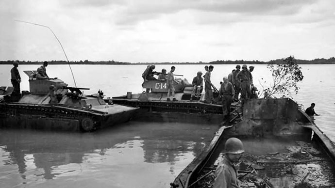
The LCM in Peleliu is likely similar to this LCM3 offloading a bulldozer on Okinawa in April 1945. Image courtesy of NARA. Download larger version (jpg, 214 KB).
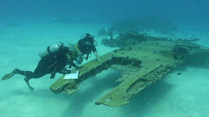
The remains of a U.S. aircraft is among the most enigmatic of our finds. The site consists of a portion of a wing with landing strut. Elsewhere in the lagoon is another strut and a radial engine we believe are associated with the site. It will take some research to resolve the type of aircraft and the circumstances of its loss.

Aerial view of the aircraft wing at low tide in the lagoon. The landing strut is visible. Image courtesy of Jason Raupp/Ships of Discovery Science Team. Download larger version (9.8 MB).

Toni Carrell examining a recently exposed Japanese gun eroding out of a defensive position. An unusual storm in October 2017 unearthed a number of items formerly buried on the shoreline and undermined this location. Image courtesy of the Ships of Discovery Science Team. Download larger version (6.6 MB).
Immediately inshore we re-examined numerous Japanese defensive positions, which were strategically located to direct enfilading fire from the shore out to the reef line, wreaking havoc on the incoming amphibious vehicles and their occupants.

Section of an August 1945 Japanese defensive plan. The red arrows are the presumed U.S. avenues of approach for the invasion. The blue arrows represent the fields of fire of the gun emplacements across the invasion beaches and reef. The blue half-circles on the beaches represent general defensive positions. Image courtesy of the Peleliu State Museum. Download larger version (3.1 MB).
We are only beginning our analysis of the data. There is still a lot to investigate and a lot to learn about this battlefield and larger battlespace. This narrowly defined Phase I survey was designed to be a first look at the offshore components of the primary invasion beaches. It did not include the locations on the opposite side of the island at beaches designated Purple and Scarlet that were used to offload equipment and supplies immediately following D-Day. Nor did we investigate the Ngedebus invasion beach, attacked on D+13, at the north end of the island. We did not visit nearby Angaur, attacked on D+2 (Peleliu), that was an integral part of OPERATION STALEMATE II. There is still the location of LCI(G)-459 to confirm, which hit a mine and sank in deep water in the channel off of Amber Beach north of White 1.
As Memorial Day 2018 approaches, it is important to consider the other reason for doing this project. It is to remember this battle, where 40 percent of the U.S. troops were casualties, 48 percent of the survivors were rotated out of the theater, and nearly 100 percent of the Japanese defenders died. It is also important to remember the Palauan, Korean, and Okinawan non-combatants who lost their lives. Seeing this battlefield firsthand and reflecting on the sacrifices and tremendous loss of life during World War II, we seek to honor those who gave the ultimate. Never Forget.