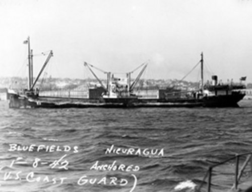

Port side view of Bluefields, photo dated January 8th, 1942, six months prior to being sunk by U-576. Image courtesy of National Archives. Download image (jpg, 33 KB).
The purpose of this expedition is to explore a World War II (WWII) maritime battlefield from the Battle of the Atlantic 35-40 miles off the coast of North Carolina to characterize archaeological and natural resources.
Following America‘s entry into WWII, German U-boat raiders attacked U.S. merchant ships off the east coast of the United States, sinking hundreds of vessels between January and July of 1942 in what is now known as the American theatre of the Battle of the Atlantic.
On the morning of July 14, 1942, 19 U.S. ships in convoy KS-520 left port in Virginia and sailed south. The next day, on July 15, just after 4:00 pm, German Submarine U-576 attacked the convoy off Cape Hatteras, North Carolina, immediately sinking one merchant ship and severely damaging two more before the submarine itself sunk in a counter attack moments later. This battle represents one of the most historically significant naval engagements of the Battle of the Atlantic off America’s shore, marking the end of U-boats as a significant threat on the East Coast.
The final resting place of the vessels lost in this battle was unknown until 2014. After several years of searching, explorers located the remains of both U-576 and the freighter Bluefields in approximately 230 meters of water 35 miles offshore, just 200 meters apart from each other. This discovery is the only known location in U.S. waters with archaeological remains from both sides of the conflict (a German submarine and a merchant ship) in such close proximity. Additionally, the wrecks serve as artificial reefs and provide significant habitat for marine life.

High resolution image of U-576. This is the only depiction of the site to date. Image courtesy of NOAA. Download image (jpg, 66 KB).
At the time the sites were discovered and verified in 2014, only sonar imaging technology was available to explore the wrecks. As a result, very limited information is known about the remains aside from the location and general orientation of the vessels. This expedition will begin to assess the significance of WWII resources off the coast of North Carolina and begin to reconstruct elements of the battlefield.
The expedition will take place in two stages; the first from August 22 to September 6, 2016, and the second from October 27 to November 10, 2016. Explorers will use advanced data acquisition and visualization technologies via two human-occupied submersibles and autonomous underwater vehicles (AUVs) to examine the two wrecks and surrounding battlefield area for their archaeological significance and associated biological habitat.

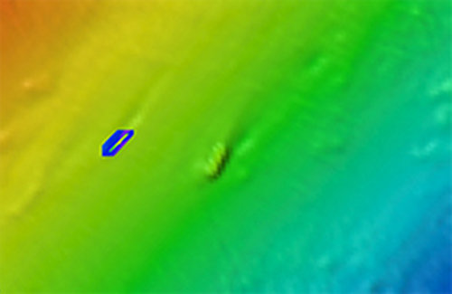
Multibeam imagery collected in 2014 shows the relative positions of U-576 (to the right) and Bluefields (in the center). Image courtesy of NOAA. Download image (jpg, 20 KB).
While the basic narrative of the battle is historically documented, more detailed questions cannot be answered without further investigating the shipwrecks. Visual inspection of the wrecks via human-occupied submersibles may provide clues as to the exact damage and cause of sinking of U-576.
Depending on the level of preservation, it may be possible to distinguish between damage caused in this battle and damage reported from previous attacks sustained prior to its sinking. It may also be possible to determine what was happening in the last moments of the sinking event based on the position of diving planes and whether or not escape hatches were opened or remain closed. Furthermore, a great deal will be learned about the state of preservation of Bluefields.
Benthic habitat mapping of the shipwreck sites, surrounding natural seafloor habitats, as well as the associated water column will help to evaluate the biological cover and fishes that use these sites as habitat.
Aboard the R/V Baseline Explorer scientists will use the following exploration tools for this expedition:
Two Triton 1000/2 manned submersibles will be used on this expedition for visual inspection of the shipwrecks and to record video footage and still imagery of the sites. Both submersibles can dive to a depth of 305 meters for 10 hours a day and can achieve three knots speed. Each submersible can hold two people: one pilot and one scientist. Having two submersibles operating together adds a level of safety as they can assist if technical issues arise with the other. Likewise, dedicating each submersible to a specific recording task increases operational efficiency. There will be continuous verbal communication and telemetry among the two submersibles and the boat.

Triton 1000/2 submersible that will serve as primary instrument platform. Image courtesy of PB/BGL. Download image (jpg, 81 KB).

The Bluefin 12-inch diameter AUV will be used for multibeam data collection. Image courtesy of SRI. Download image (jpg, 7 KB).
The AUV Bluefin will be used to collect high-resolution multibeam sonar data to explore the battlefield area and surrounding habitat. The data will help locate potential debris fields associated with the battle and will be the primary tool for benthic habitat characterization and identifying biological resources in the water column. Bluefin can dive to a depth of 1000 meters for eight hours at a time and at a speed of three to five knots. The relative stability of AUVs in areas of high currents makes them ideal for collecting high-resolution multibeam sonar data.

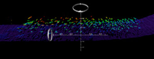
Multibeam image of a school of fish above the seabed. Image courtesy of SRI. Download image (jpg, 18 KB).
A high-resolution multi-beam sonar system will be mounted on the AUV to cover a wide area of the battlefield. The sonar system will send a pulse of sound into the water and will “listen” for the sound’s echo, i.e., the strength of the signal coming back after bouncing off the seafloor or an object in the way. By determining the time between sending and receiving the sound pulse, the system can determine the range of the object, and thus generate bathymetric data and locate potential debris fields on the seafloor. Flying the AUV close to the seafloor will provide great resolution of both bathymetry and detection of fishes associated with shipwrecks and natural hard bottom habitats.
Taken together, these exploration technologies will provide valuable findings for both archaeological and biological research off the coast of North Carolina in the Battle of the Atlantic area.