By Jay Lunden, Principal Investigator - Temple University,
Charles Fisher, Principal Investigator - Pennsylvania State University
and Greg Boland, Biological Oceanographer - Bureau of Ocean Energy Management

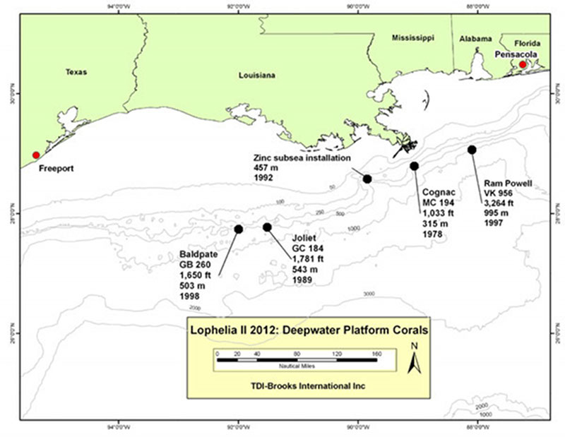
Map displaying Gulf of Mexico deepwater oil and gas platforms targeted for study during the expedition. These platforms, sitting vertically in the water column, provide a suitable structure for deepwater coral larvae to attach and grow. Image courtesy of Lophelia II 2012 Expedition, NOAA-OER/BOEM. Download larger version (jpg, 600 KB).
After four years of work, we are embarking on our fifth and final cruise to the Gulf of Mexico as part of the Lophelia II project, sponsored by the Bureau of Ocean Energy Management (BOEM) and the NOAA Office of Ocean Exploration and Research (OER). Scientists from the U.S. Geological Survey are also participating, continuing their collaboration and complimentary studies since the beginning of the Lophelia II project.
Our overall goal for this project is to explore areas of the Gulf of Mexico that may harbor new coral communities and collect data on their habitat characteristics, ecology, physiology, and population structure. Using this information, we can develop tools to enhance our ability to predict coral occurrence in the Gulf and beyond and to provide critical information necessary to BOEM for managing our nation’s offshore resources in an environmentally responsible way.
This cruise, aboard the Research Vessel Brooks McCall with the remotely operated vehicle (ROV) Kraken II, is different from our previous expeditions to the Gulf. We will be exploring a new realm of habitats for cold-water corals: oil and gas platforms. Oil and gas platforms are found throughout most of the central and western Gulf of Mexico, and the industry has expanded to the deep waters far offshore. Some platforms are supported by large vertical structures that extend to the seafloor while others are floating structures secured in place by anchors. Since corals have a planktonic larval stage, they spend about two weeks in the water column and can settle on the vertical members of these platforms. Over time, the corals can rapidly colonize the members and expand over them.

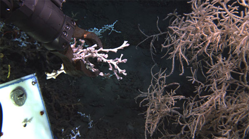
Remotely operated vehicle manipulators are used to collect specimens of corals for use in numerous studies. Image courtesy of Lophelia II 2012 Expedition, NOAA-OER/BOEM. Download larger version (jpg, 500 KB).
Our primary mission on this cruise is to study the corals (particularly Lophelia pertusa)on the vertical members of a series of platforms. To do this, we will use the Kraken II ROV equipped with a series of high-definition cameras and sampling equipment. Since we know the age of each platform, we can use images we collect to calculate the corals’ minimum growth rates. The coral depth distribution patterns will provide important information on coral tolerances to temperature and other environmental variables that change with depth.
During the cruise, we will also collect coral samples for a series of purposes, including to conduct laboratory experiments to determine physiological responses of corals to a variety of variables, to characterize the microbial communities that live in symbiosis with the corals, to isolate coral DNA and determine how these corals are connected with other coral populations in and outside of the Gulf, and to test another method to age the corals using radiocarbon dating of their skeletons.
We will also collect water samples to measure the carbonate chemistry parameters of the water column to contribute to our ongoing studies of ocean acidification. Finally, we will collect push core samples of the sediments near and far from the platforms to investigate the effects of the structures on the mobile animals that live around them and on the communities of very small invertebrates that live in the sediment.
To accomplish all of this work, we will be spending 10 days at sea with a very busy schedule. We will depart from Freeport, Texas, and first head to a group of three platforms about 100 miles offshore of central Louisiana. These platforms range from 14 to 24 years old and are at depths of 400 to 550 meters. After completing our work at these western-most platforms, we will head about 120 miles to the east and start work on the platforms off the coast of eastern Louisiana, Mississippi, and Alabama. The shallowest platform here is in 315 meters of water; installed in 1978, this platform is also the oldest we will visit. The deepest platform we will visit is also in the group; it is about 75 miles off shore of Alabama in water almost one kilometer deep.
We will wrap up the cruise with a short visit to one of the biggest natural deep-water reefs in the Gulf of Mexico to collect a few pieces of coral for laboratory experiments. We will then return to port in Pensacola, Florida. But the work doesn’t end after the cruise – after shipping all of our samples and many terabytes of video and other data back to our labs, we will have experiments to run and lots of images to analyze as we prepare our final report for BOEM and NOAA.