An official website of the United States government
Here’s how you know
Official websites use .gov A
.gov website belongs to an official government
organization in the United States.
Secure .gov websites use HTTPS A
lock (
) or https:// means you’ve safely connected to
the .gov website. Share sensitive information only on official,
secure websites.
Acoustic Mapping and Characterization of Seafloor Hydrothermal Discharge With Multibeam Echosounders on Uncrewed Underwater Vehicles
Completed
Primary Goal
Develop and demonstrate techniques to more efficiently find and characterize hydrothermal vents using uncrewed underwater vehicles equipped with coordinated multibeam sonars
Axial Seamount off the Oregon Coast, the location of the Acoustic Mapping and Characterization of Seafloor Hydrothermal Discharge With Multibeam Echosounders on Uncrewed Underwater Vehicles project. Base map courtesy of General Bathymetric Chart of the Oceans (GEBCO); NOAA National Centers for Environmental Information (NCEI). Download largest version (jpg, 206 KB).
To improve our understanding of hydrothermal vents in areas of national importance, a research team developed acoustic techniques to more efficiently find and characterize these deep-ocean features using uncrewed underwater vehicles equipped with multibeam sonars. In August 2025, they used a remotely operated vehicle (ROV) to collect sonar data at vent sites on Axial Seamount, an underwater volcano about 500 kilometers (311 miles) off the Oregon coast. They are now using these data to refine techniques for creating 3D views of hydrothermal activity.
Tubeworms on the top of the Canadian-American Seamount hydrothermal vent field on Axial Seamount in August 2025. Tubeworms thrive in, and depend on, the extreme conditions created by hydrothermal vents. Image courtesy of UW/NSF-OOI/WHOI J2-1730; V25. Download largest version (jpg, 5.0 MB).
Hydrothermal vents are important to society and economies. They host metal-rich deposits and unique biological communities that may offer clues about the origin of life and the possibility of life beyond Earth. Yet, most known vents are poorly studied, and many more are undiscovered due to the challenges of deep-ocean exploration and inadequate characterization techniques. With their new techniques, this team aims to change that.
A New Way to Explore the Deep Ocean
The team adapted their proven techniques for using multibeam sonar to characterize hydrothermal vents from a stationary platform for use on uncrewed underwater vehicles.
Multibeam sonar systems are used to collect detailed information about the seafloor and the water column, including bathymetric and backscatter data. Backscatter refers to sound waves reflected back to their source after hitting the seafloor or something in the water column that can scatter and distort sound waves, like temperature changes caused by vent fluids and the suspended particles they carry. Analyzing these reflections helps scientists find and characterize hydrothermal discharge.
Schematic illustrating how an autonomous underwater vehicle (AUV) could be used to collect seafloor backscatter data using a multi-sonar imaging system as originally envisioned by the Acoustic Mapping and Characterization of Seafloor Hydrothermal Discharge With Multibeam Echosounders on Uncrewed Underwater Vehicles project team. Image courtesy of Kim Reading, Applied Physics Lab, University of Washington. Download largest version (jpg, 364 KB).
Initially, the team planned to install two Kongsberg M3 sonars and a Kongsberg EM2040 multibeam echosounder on an autonomous underwater vehicle (AUV). The M3 sonars would work together to collect seafloor backscatter data for mapping hydrothermal activity, while the EM2040 would collect water column backscatter data and high-resolution seafloor bathymetric data.
Together, these data allow scientists to:
Locate vent-field structures, like chimneys, and other features (seafloor bathymetric data);
Generate acoustic images of hydrothermal plumes above vent structures (water column backscatter data); and
Locate active hydrothermal sources (seafloor backscatter data).
Their original plan for collecting seafloor backscatter data was to mount two separated sonars on an AUV. As the vehicle moved forward, the forward unit would “ping” first, followed by the rear unit, both scanning and recording backscatter from the same patch of seafloor. In the absence of variations in water column properties — particularly temperature — between the sonars and the seafloor, the data should be nearly identical. Differences could indicate temperature anomalies associated with hydrothermal discharge.
After each M3 ping sequence, the EM2040 would collect bathymetric and water column backscatter data. When a vent is present, the M3 and EM2040 data can be combined to create a detailed 3D panoramic image of the site.
Following computer simulations and tank experiments, the team was ready for field deployment.
Adaptation and Demonstration
The team originally planned to demonstrate their techniques on Woods Hole Oceanographic Institution’s (WHOI’s) AUV Sentry in September 2024. However, a water leak irreparably damaged one of the M3s. To proceed with a single M3, the team shifted their efforts to WHOI’s ROV Jason, which offers better speed and movement control than an AUV like Sentry.
Remotely operated vehicle (ROV) Jason being lowered into the water from the ship for a dive to the summit caldera of Axial Seamount. Jason was built and operated by the National Deep Submergence Facility, Woods Hole Oceanographic Institution. It was used by the Acoustic Mapping and Characterization of Seafloor Hydrothermal Discharge With Multibeam Echosounders on Uncrewed Underwater Vehicles project team to demonstrate their techniques for finding and characterizing hydrothermal vents. Image courtesy of UW/NSF-OOI/WHOI J2-1727; V25. Download largest version (jpg, 2.14 MB).
Remotely operated vehicle (ROV) Jason before launch for dive J1733 during the Ocean Observatories Initiative RCA VISIONS 25 expedition. The Kongsberg M3 used to collect seafloor backscatter data for the Acoustic Mapping and Characterization of Seafloor Hydrothermal Discharge With Multibeam Echosounders on Uncrewed Underwater Vehicles project is shown on the front of the port side of the vehicle. Image courtesy of UW/NSF-OOI/WHOI J2-1733; V25. Download largest version (jpg, 1.83 MB).
In August 2025, they joined the Ocean Observatories Initiative’s VISIONS’25 expedition on the Office of Naval Research’s Research Vessel Atlantis (operated by WHOI). Using Jason equipped with an EM2040 and the remaining M3, they collected mapping and backscatter data during two dives on Axial Seamount at the ASHES (Axial Seamount Hydrothermal Emission Study) vent field off Oregon’s coast.
Since the dual-M3 system was now a single-M3 system, they modified their plans, collecting data in two modes:
In continuous mode, the ROV moved slowly, collecting sonar data at a high ping rate.
In “stop-and-hop” mode, the ROV hovered over specific points on the seafloor, collecting sonar data for about 20 seconds.
Maps showing seafloor backscatter intensity (top) and decorrelation (ping-to-ping variation, bottom) generated from data collected at the ASHES (Axial Seamount Hydrothermal Emission Study) vent field for the Acoustic Mapping and Characterization of Seafloor Hydrothermal Discharge With Multibeam Echosounders on Uncrewed Underwater Vehicles project. The Mushroom vent is labeled in the backscatter intensity map. The “hot spots” in the bottom map are anomalies indicating potential hydrothermal sources. Image courtesy of UW/NSF-OOI/WHOI J2-1733; V25. Download largest version (jpg, 1.58 MB).
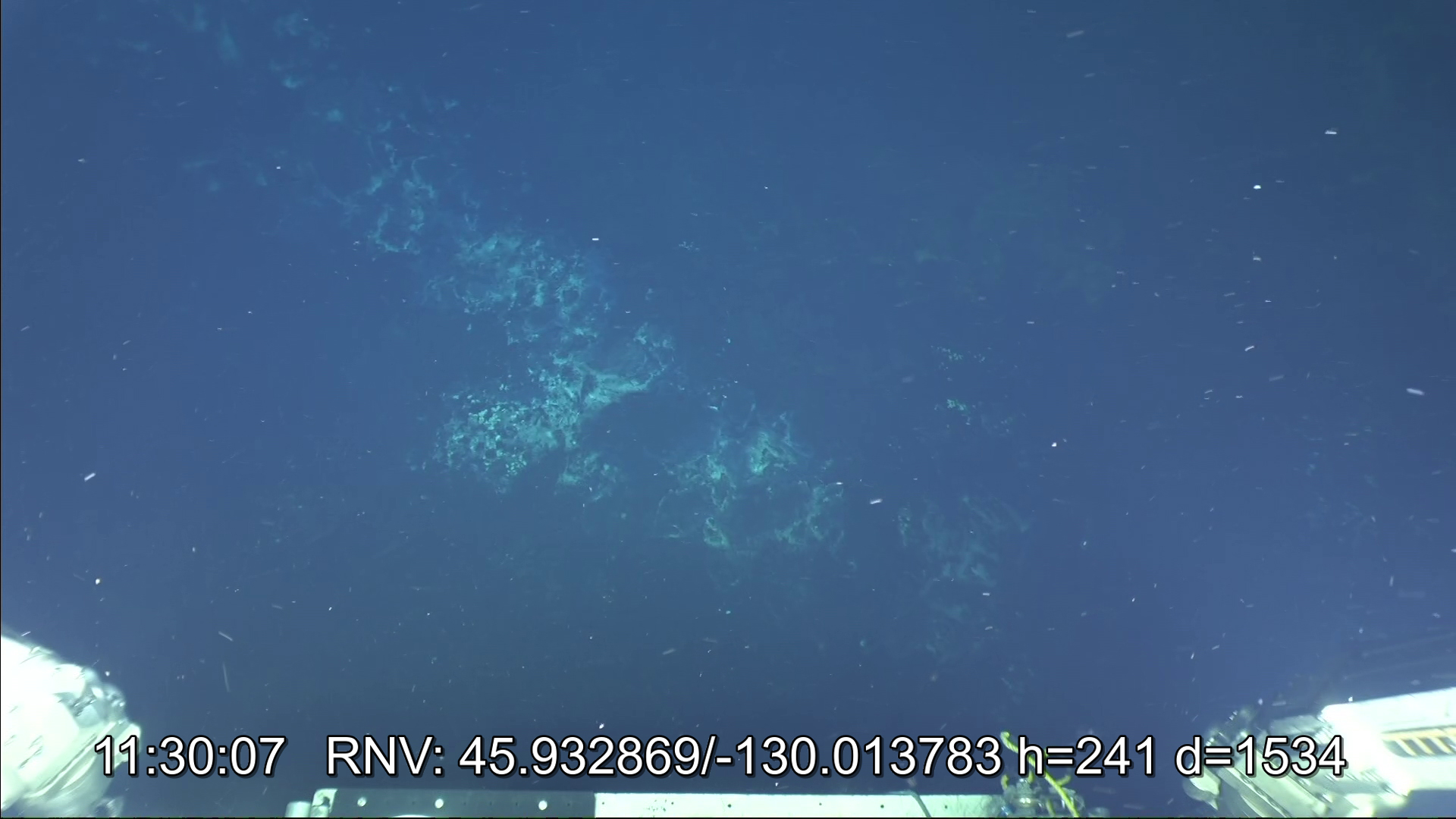
Hydrothermal activity on the Canadian-American Seamount hydrothermal vent field on Axial Seamount captured by remotely operated vehicle Jason: A water column backscatter image of a hydrothermal plume rising from a vent (top) and an animation of water column backscatter images of hydrothermal plume(s) rising from a large sulfide structure (bottom). Similar data were collected during the Acoustic Mapping and Characterization of Seafloor Hydrothermal Discharge With Multibeam Echosounders on Uncrewed Underwater Vehicles project team’s exploration of the ASHES (Axial Seamount Hydrothermal Emission Study) vent field during the same expedition. Image and animation courtesy of UW/NSF-OOI/WHOI J2-1730; V25. Download largest version of image(jpg, 1.25 MB). , Download largest version of animation (gif, 13.5 MB).
The seafloor backscatter data showed areas of high variability, likely associated with vent fluids. These areas aligned with visual imagery from Jason’s cameras and plumes seen in the water column backscatter data from the EM2040, validating the approach.
Diffuse hydrothermal discharge at the ASHES (Axial Seamount Hydrothermal Emission Study) vent field on Axial Seamount. The white patches are mineral deposits and/or bacterial mats where active venting is occurring. This activity was also seen in the seafloor backscatter data collected at the site during the Acoustic Mapping and Characterization of Seafloor Hydrothermal Discharge With Multibeam Echosounders on Uncrewed Underwater Vehicles project. Image courtesy of UW/NSF-OOI/WHOI J2-1731; V25. Download largest version (jpg, 513 KB).
What’s Next?
The team’s adaptability led to a successful field operation and effective data collection for the next step in the project. They are now analyzing and combining the sonar datasets to create a detailed 3D view of hydrothermal activity at the ASHES vent field.
By enhancing the capabilities of uncrewed underwater vehicles to find and characterize hydrothermal sources, this project can help us better understand hydrothermal vents and their role in oceanic and geological processes to inform research and management decisions, as well as the study and exploration of other seafloor emissions, like methane seeps.
A plume rising from a smoker on the Inferno hydrothermal sulfide structure within the ASHES (Axial Seamount Hydrothermal Emission Study) vent field on Axial Seamount in August 2025. The instrument is a temperature logger that measured fluid temperature inside the smoker. Image courtesy of UW/NSF-OOI/WHOI J2-1729; V25. Download largest version (jpg, 2.5 MB).
Multimedia
The images and videos from this project add context and help bring the project to life. Click on a preview image below to view the full image and get more information.
Ocean Science for Educators provides the best of what the NOAA Ocean Exploration website has to offer to support educators in the classroom. Each theme page includes lessons, fact sheets, ocean facts, exploration notes, multimedia, and related past expeditions and projects. Below are the top education themes related to this project.