


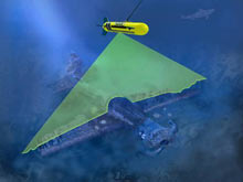
The laser line scan (LLS) systems utilize a sweeping blue-green laser to reflect light across the seafloor to generate a gray-scale image similar to a black and white photography. Click image for larger view and image credit.
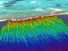
Figure 1. An example of a seafloor map made from multibeam echosounder data. The data illustrated here were collected by the NOAA Pacific Islands Fisheries Science Center at Kure Atoll in July 2006, and are overlain on satellite imagery of the atoll. The multibeam data are color-coded by depth (reds are shallow, blue colored areas are deeper) and clearly illustrate the spur-and-groove morphology often found in coral reef ecosystems. Click image for larger view and image credit.
Mission Plan
John Rooney
Chief Scientist
Joint Institute for Marine and Atmospheric Research
The world’s coral reefs are in serious jeopardy, as a result of a wide and increasing array of threats. In response to this growing environmental crisis the U.S. Coral Reef Task Force (CRTF) was established, and released the National Action Plan for Coral Reef Conservation, the first comprehensive U.S. strategy to conserve coral reefs. The first of 13 goals outlined in the plan call for mapping of U.S. coral reefs. Accurate and detailed maps are essential for effective management and protection of coral reefs. It is difficult to protect and manage a living resource if you don’t know where it is and of what organisms the community is comprised.
Very detailed and accurate maps of seafloor depth are being made of coral reef ecosystems at U.S. and U.S.-affiliated islands across the Pacific, using sophisticated multibeam echosounder systems. However, still or video photography or direct observation is required to confirm the presence of absence of corals and other organisms living on or near the seafloor. To accurately census coral reefs and identify the organisms living in an area, the camera or observer must be very close to them, even in the clear waters typically found around remote tropical islands. This means that the portion of the seafloor being photographed or observed is quite small, so a large number of photographs or observations must be collected to effectively map even a small area. Diver-based methods have proven to be reasonably effective method to collect imagery in shallow marine environments. At depths below about 25 m to 30 m (80-90 ft) logistical challenges begin to increase dramatically, making this method unfeasible for collecting enough imagery for effective mapping. A number platforms have been used for photographing the seafloor, including drop and towed camera systems, remote operated vehicles (ROVs), autonomous underwater vehicles (AUVs), submersibles, divers, and more. Unfortunately, they are all limited by the requirement to be close to the reef being photographed or observed.
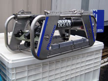
Figure 2. An underwater camera sled used by the NOAA Pacific Island Fisheries Science Center for collecting photographs and videos of coral reefs. Click image for larger view and image credit.
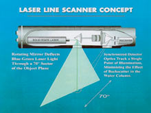
Figure 3. The Laser Line Scan (LLS) concept. Click image for larger view and image credit.
To solve this problem a different tool is required that can collect high-quality, accurately geo-registered visual data in large quantities. It must provide high-resolution seafloor habitat information, along with its associated marine life. Finally, it must cover a large enough area to capture rare habitats and be statistically useful. Laser line scan (LLS), an electro-optic imaging technique, is an excellent candidate because it combines the efficiency and spatial coverage of a remote survey system with an image resolution approaching that of visual observations. These optical images can resolve centimeter sized objects at two to five times the range of conventional video and photographic systems. LLS technology may be especially well suited for the clear waters typically found around tropical Pacific Islands, since image resolution and scanning area are adversely affected by poor water clarity. This will allow the survey vehicle to be towed high above the seafloor where necessary, greatly reducing the risks to the vehicle.
Although it has been in use for decades, laser line scanning is much less common that underwater photography, and there is only one laser line scan system commercially available in the world today. That system, called the SM-2000, was built by Northrop Grumman, and is owned and operated by Scientific Applications International Corporation (SAIC). The SM-2000 consists of a solid state blue-green laser that is aimed at a rotating mirror assembly. The mirrors quickly sweep the laser light across a downward pointing arc, while detector optics record the light reflected back from the seafloor. Variations in the reflected light are used to generate a gray scale image of the seafloor – essentially a black and white photograph of a strip of the ocean bottom that may be about 100 ft wide and could extend for miles.
The system is typically used to survey pipelines on the seafloor, wreckage of aircraft or ships, and other relatively small areas. It has also been used to survey crab populations in the Gulf of Alaska, archaeological ruins off the coast of Italy, and for benthic habitat mapping in the Big Creek Ecological Reserve in Monterey Bay, California. Despite its wide use in a number of marine environments and for a wide range of missions, the system has never before been used to map coral reefs. The purpose of this expedition is to test the ability of laser line scan technology to map coral reef organisms.
The LLS system will be installed on the NOAA Ship Hi’ialakai on November 6-7, 2006. On November 8th, the ship will get underway and make the approximately 80 nautical mile transit to the Hawaiian Island of Maui. Once there, a conductivity-temperature-depth (CTD) instrument will be lowered over the side of the Hi’ialakai to a depth of approximately 1,000 ft. Data from the CTD enable us to accurately compute the the speed of sound at depths throughout the water column. These data are critical for accurate miltibeam mapping of the seafloor. The multibeam echosounders on the Hi’ialakai will be operated during the cruise to warn of us any obstructions on the seafloor that may be hazardous to the LLS such as uncharted shipwrecks. They will also collect higher-resolution data than are currently available for the areas we will be surveying. After the CTD is completed, the LLS will be deployed to begin surveying.
During the next six days we will survey 24 hours per day, with two teams of scientists standing watch 12 hours a day. Scientists from SAIC, the NOAA Pacific Islands Fisheries Science Center, the Hawaii Mapping Research Group at the University of Hawaii, the NOAA Biogeography Program, the Hawaii Undersea Research Laboratory, the Hawaii Division of Aquatic Resources, and the NOAA Office of Ocean Exploration will help with this effort. Survey targets for the cruise will include:
- Habitat for commercially important groundfish, and a potential nursery area for them.
- Deep scleratinian (stony) coral reef areas.
- Beds of black coral, which are another commercially-harvested living marine resource in the area.
- A World War II era U.S. Navy aircraft wreck of historical interest.
- Deep beds of the endemic calcareous algae Halimeda kanaloana.
A handful of questions about the ability of the LLS system will be addressed for each of the survey targets, such as what is the highest altitude at which we can still identify the fish, corals etc. that we are surveying. We want to know how well we will be able to identify different organisms. For example, can we identify individual coral or fish species? We will also learn as much as possible about how to deploy and effectively survey with the LLS. Since it is an optical system, sunlight may add noise rather than clarity to the imagery we generate. So we’d like to know how shallow we can operate the system during the day in clear tropical waters and still collect good data. While we’re answering these questions, we’ll also be collecting data to assist with ongoing research and management of living marine resources around Maui.
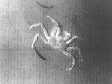
Figure 4. Laser line scan image of an Alaskan Red King Crab. Click image for larger view and image credit.
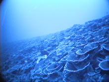
Figure 5. The deep stony coral reef off the island of Maui, which may be the deepest known reef in the US. Click image for larger view and image credit.
Perhaps the most exciting aspect of this cruise is that we will see high-resolution imagery from parts of the seafloor than have never been photographed or observed, and there is the potential for encountering new and unexpected discoveries. Two years ago, the luxuriant deep coral reef we will survey was discovered by Tony Montgomery of the Hawaii Division of Aquatic Resources, while he and his team were surveying black coral beds. Such discoveries have the potential to literally change the way we think about the underwater world.