


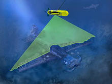
The laser line scan (LLS) system uses a sweeping blue-green laser to reflect light across the sea floor and to generate a gray-scale image similar to a black-and-white photograph. Click image for larger view and image credit.
Operation Laser Line 2006
November 8 - 13, 2006
Mapping the coral reefs has been identified as one of the first and most important steps needed to address the increasing decline of the world’s coral reefs. Either photography or direct observation is required to identify corals and other coral-reef community organisms, but only small areas can be covered with these techniques. Laser line scanning has been suggested as an alternative method that can provide high-resolution imagery of the sea floor over a much wider area than conventional photography. Laser line scan (LLS) systems sweep a blue-green laser across the ocean bottom and use the reflected light to generate a gray-scale image of the sea floor, similar to black-and-white photography.
The NOAA Pacific Island Fisheries Science Center, in collaboration with partners from the NOAA Office of Ocean Exploration, the Hawaii Undersea Research Laboratory, the Hawaii Division of Aquatic Resources, and the University of Hawaii Botany Department will embark on a six- day research cruise, from November 8 to 13, 2006. The only commercially available LLS system in the world will be deployed at a handful of sites off the coast of Maui. Expedition survey targets include beds of commercially harvested black coral; a recently discovered, deep, hard-coral reef; an important nursery area and fishing site for commercially harvested groundfish; deep algae beds; and a World War II aircraft wreck. This wide range of targets will enable us to thoroughly evaluate LLS technology, and hopefully provide the impetus to design less expensive and more capable LLS systems to meet the management and research needs of our coral reef ecosystems.
Mission Facts
- Although laser line scan (LLS) systems have been in existence for decades, there is only one system in the world — Scientific Applications International Corporation’s Northrop-Grumman SM-2000 — that is commercially available.
- The SM-2000 LLS system uses blue-green laser light to image the ocean bottom. The combination of a blue-green light source and laser light enables the system to image objects at up to five times the range of conventional photography.
- LLS sends and receives the laser light by bouncing it off of two separate four-sided, pyramid-shaped rotating mirrors.
- The LLS system generates data so detailed that operators have captured images of individual crabs, strands of kelp, and even the Nike "Swoosh" logo on a shoe lying on the ocean bottom.
- Deep algae beds being surveyed with the LLS during this expedition are composed of the endemic algae Halimeda kanaloana. In general, over 25% of Hawaiian reef organisms are endemic (found nowhere else in the world).
- The laser beam generated by the LLS moves along the sea floor at speeds on the order of 10 m in a few milliseconds, or approximately 2 mi per hr.
- The deep scleractinian (stony) coral reef complex off Maui that researchers will survey during this expedition is among — and may, in fact, be — the deepest reef with almost complete coverage of the sea floor by hard corals, in United States waters.
- Because the LLS system can be towed at much higher altitudes above the sea floor and doesn’t need the bright light systems typically found on remotely operated vehicles, drop camera systems, etc., the LLS has a minimal impact on marine organism behavior. As a result of these characteristics, LLS technology appears to offer great promise as a means of accurately sampling populations of fish and other organisms that live on or near the sea floor.
- The entire LLS system requires two to three 20-ft shipping containers to hold all the equipment needed to install it on a research or survey vessel.
- Black corals in Hawaii are typically harvested by individual scuba divers who descend to depths of between 150 and 200 ft, or deeper. Using a hatchet, they cut off black coral “trees” meeting the minimum size requirements and send them in bunches to the surface with lift bags. As their air runs low, the divers ride the last bag up to a depth of 60 ft or so to decompress. Many divers have been seriously injured or killed following this risky protocol.
Updates & Logs
Click images or links below for detailed mission logs and updates.
 Mission Summary Although the Operation Laser Line 2006 did not go as planned, the team collected enough laser data to evaluate the effectiveness of the laser line scanner in coral reef ecosystems.

 November 13 The Operation Laser Line team adapts to the new circumstances and begins underwater mapping off Hawaii's Big Island.
 November 11 For Chief Scientist John Rooney and the Laser Line team, high hopes have ended in disappointment.
 November 10 "We lost the 'fish'!" The tow sled accidentally strikes an escarpment, which leads to the loss of the laser line scanner.
 November 9 The team tests the laser line scanner and creates near photographic maps of the sea floor and its inhabitants, including small white sea fans living at 250 m depth.