


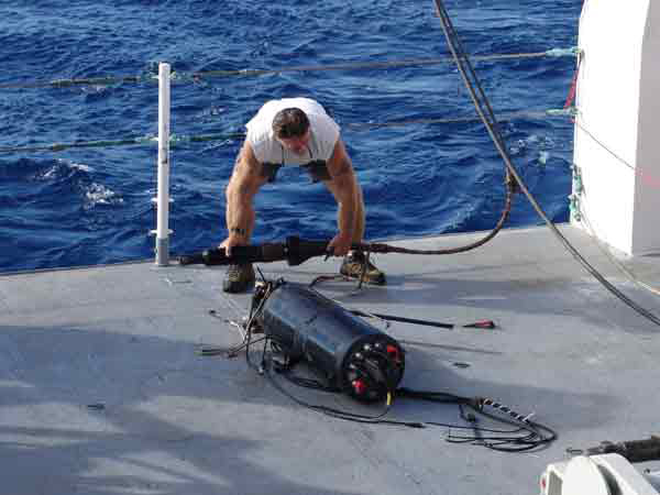
Laser line scan (LLS) survey team member John Stange examines the tow-sled control body after it was retrieved. Click image for larger view and image credit.
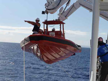
The NOAA research vessel (R/V) Hi'ialakai deploys a small boat with three crew members aboard in an attempt to recover the detached equipment. Click image for larger view and image credit.
"We Lost the 'Fish'!"
November 10, 2006
David Sallis
Web Coordinator
General Dynamics
National Coastal Data Development Center
Scott Ferguson
Lead Logistics Coordinator
NOAA Coral Reef Ecosystems Division
Pacific Islands Fisheries Science Center
After losing nearly a full day's survey time due to communication problems with the laser line scanner, the science party aboard the research vessel (R/V) Hi'ialakai was in better spirits once the issue was resolved and the scanner re-deployed to the bottom late Thursday night. As the tow sled neared the bottom, the image on the topside monitor resolved from "chaotic noise" to a coherent picture, providing the scientists with high-resolution images of the sea floor off the northwest coast of Maui. After experimenting a little to find the optimum altitude of the scanner above the bottom, the survey team settled in for a night of work monitoring the scanner and recording data.
At 8:30 the next morning, as we drank coffee in the ship's dry lab and watched imagery from the scanner scroll down the monitor screen, we suddenly lost the signal from the scanner. Puzzlement quickly turned into "that sinking feeling" as data from the side scan sonar (which was mounted on the scanner's tow sled) showed the altitude of the scanner above the sea floor had quickly turned to zero. "Zero altitude" meant that the tow sled had collided with the bottom. In fact, what had happened was that the ship had traversed from an area with a relatively flat bottom to an area with more vertical relief, and the tow sled struck an escarpment as the ship passed over.
The tow cable was reeled in and our worst-case scenario was confirmed: the only thing on the end of the tow cable was the sled's "control body," the package of electronics that enables the operator on the surface to "fly" the sled above the bottom by remotely manipulating the sled's dive planes, much like flying an aircraft. The tow sled, and the precious laser line scanner it carried, had been sheared away from the control body by the force of the impact. The ship quickly turned around to attempt to recover the tow sled, pieces of which could be seen in the distance bobbing on the surface. As we neared the area where we saw debris, the ship deployed one of her small boats with three crew members aboard, who raced off toward the rapidly disappearing pieces of tow sled. In the end, only a few pieces of flotation material were recovered. Of the sled and the scanner: there was no sign.
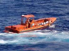
The R/V Hi'ialakai crew members search for debris. Click image for larger view and image credit.
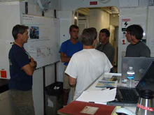
The LLS survey team discusses recovery options. Click image for larger view and image credit.
Back on the R/V Hi'ialakai, survey team members discussed recovery options. The sled's transponder had been located on the sea bottom via the ship's sonar, and its location was pinpointed. A plan to bring a remotely operated vehicle from Honolulu was briefly pondered, then abandoned as impractical and time-consuming. Reluctantly, the team decided to wait to attempt recovery of the scanner until next week, when another survey team would be back in the area. Before we left the area, though, the ship traversed the area, scanning the bottom with her high-resolution multibeam bathymetry sonar, to thoroughly map the the sea bottom as an aid in recovery planning.
The fall-back plan for the remainder of the cruise is to traverse to the Big Island of Hawai'i and perform some bathymetry surveys. The reason for this is that newly collected high-resolution bathymetry data is being assembled by the University of Hawaii to construct a more accurate map of the seabed surrounding the Hawaiian Islands. Since some of the high-priority outstanding areas are near the west coast of the Big Island, and Hi'ialakai's multibeam sonars are the perfect tools for this type of survey, the scientific party decided to spend the remaining time collecting data there.
After we scanned the accident site with the multibeam sonar, Hi'ialakai set course for the Big Island, eight hrs away from her present location.
Why We Need the Laser Line Scanner
November 10, 2006
Tony Montgomery
Marine Biologist
Hawaii Department of Land and Natural Resources
Division of Aquatic Resources
After awaking from a few hours sleep, I was disappointed to hear that the laser line scan towfish had experienced some difficulties earlier with a steep incline in the northern Au'au Channel. This was particularly disappointing to me as the area where the towfish was lost is a hotspot for the alien invasion by the "snowflake" coral in Maui’s deep black-coral bed. We were really hoping to see if the laser line scan (LLS) technology would allow us to distinguish black coral colonies from colonies with snowflake coral overgrowth. The difficult terrain that the towfish was scanning makes this habitat ideal for both black coral and snowflake coral.
We are still left with the question of how well this technology can let us describe large areas of black coral habitat. However, based on preliminary observations last night, Dr. Chris Kelley and I were able to analyze some rough LLS data and debate on the species of corals observed below 200 m. The laser-generated data gave us a very positive identification, and we determined that the laser is ideally suited to view the entire black coral population in prime habitats. In addition, I am positive we would be able to generate density estimates and even some size estimates of colonies in the scanned areas.
Clearly, we need to look further at this technology in order to study and understand deep-water coral habitats and ecology. If we were able to map out large areas of deep-water corals at the resolution provided by the LLS, then we could begin to understand more about individual populations and their distributions.
Sign up for the Ocean Explorer E-mail Update List.