Multibeam Sonar
Multibeam sonar is a type of active sonar system used to map the seafloor and detect objects in the water column or along the seafloor. The multiple physical sensors of the sonar – called a transducer array – send and receive sound pulses that map the seafloor or detect other objects. A multibeam array is usually mounted directly on the ship’s hull.

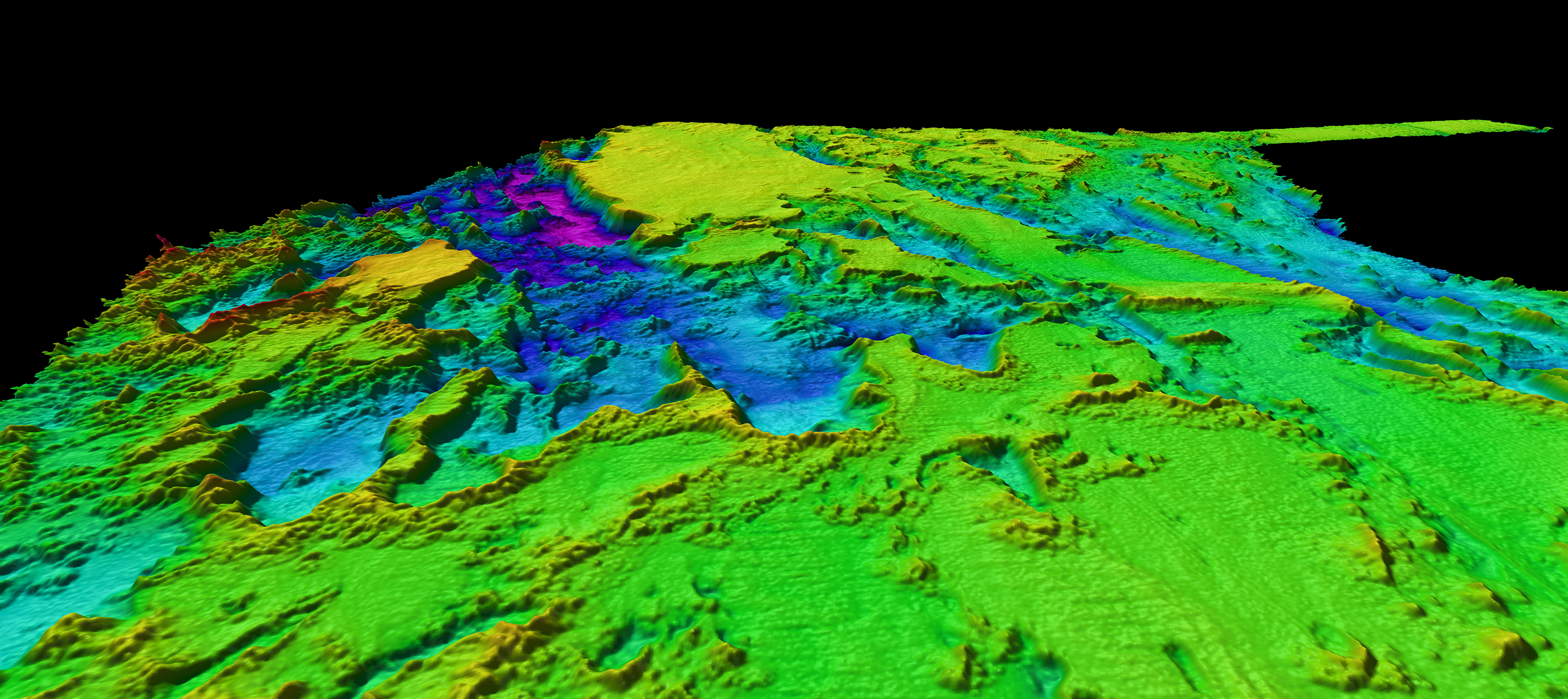
Multibeam bathymetry collected during Leg 1 of the Windows to the Deep 2019 expedition offshore the southeastern United States revealed several interesting features that were investigated via remotely operated vehicle exploration during Leg 2 of the expedition. Image courtesy of NOAA Ocean Exploration, Windows to the Deep 2019. Download larger version (jpg, 2.8 MB).
How does it work?
Unlike single-beam sonar, which uses just one transducer to map the seafloor, a multibeam sonar sends out multiple, simultaneous sonar beams (or sound waves) at once in a fan-shaped pattern. This covers the space both directly under the ship and out to each side. Multibeam collects two types of data: seafloor depth and backscatter. The seafloor depth, or bathymetry, is computed by measuring the time it takes for the sound to leave the array, hit the seafloor, and return to the array. Scientists onboard the ship take measurements of the speed of sound in the water where they are surveying so they can translate the two-way travel time from the ship to the seafloor and back as a depth measurement. Backscatter is a measurement of the intensity of the sound echo that reflects back to the multibeam array.
Video courtesy of NOAA.
Backscatter results can provide scientists with information about the geological makeup of the seafloor or objects on it. For example, hard, rocky materials will generally reflect more sound than a softer material like mud.
Multibeam sonars also can collect backscatter measurements for features that reflect sound in the water column. Water column backscatter data can be used to reveal objects in the water column, such as three-dimensional structures associated with shipwrecks, bubble plumes emanating from the seafloor, and dense layers of biology.
What happens next?
Computers on the ship collect these data and hydrographers process the data to create colorful two- or three- dimensional bathymetric (water depth) maps that help visualize the seafloor. In the bathymetric map example shown below, the warmer colors (red and orange) correspond to shallower areas, while the cooler colors (yellow and green) indicate deeper areas.
 is shown rising from the seafloor at Vailulu’u Seamount in a single ping of midwater multibeam sonar data, collected during the 2017 American Samoa expedition.")
A plume of bubbles (light green and yellow) is shown rising from the seafloor at Vailulu’u Seamount in a single ping of midwater multibeam sonar data, collected during the 2017 American Samoa expedition. Image courtesy of NOAA Ocean Exploration, 2017 American Samoa. Download larger version (jpg, 359 KB).
Why is it important?
Multibeam sonar is useful for both water column and seafloor characterization. For example, in the water column multibeam backscatter data can pick up on plumes of bubbles. This may indicate the presence of a cold seep, which is an area where gas escapes from the seafloor. Bubble plumes can also be associated with hydrothermal vents that support unique biological communities.
When mapping the seafloor, a multibeam survey does a broad sweep of the area, and is therefore an efficient way to systematically map large regions. However, the deeper the water depth, the lower resolution this map of the seafloor will be. In order to map the seafloor in very high resolution, it is necessary to have mapping sonars close to the seafloor, which can mean towing them from ships or mounting them on remotely operated vehicles (ROVs) or autonomous underwater vehicles (AUVs). Thus, multibeam mapping is sometimes used in tandem with side scan sonar systems towed close to the seafloor, which provide higher resolution imagery of seafloor features.
A multibeam sonar survey is often one of the first steps in exploring a new area. After determining the depth, shape, and character of the seafloor, scientists can plan more comprehensive dives for ROVs. The character of sediment identified by multibeam, and verified with ROV video imagery, also gives clues to what organisms may live in the area and aids in the process of habitat suitability mapping. Initial multibeam mapping lays the foundation for answering more specific exploration and research questions about our ocean.
The text of this article is adapted from How Multibeam Sonar Works and How does backscatter help us understand the seafloor (from the National Ocean Service.)?
SONAR, short for SOund NAvigation and Ranging, is a tool that uses sound waves to explore the ocean. Scientists primarily use sonar to develop nautical charts, located underwater hazards to navigation, search for and identify objects in the water column or seafloor such as archaeology sites, and to map the seafloor itself. With a sonar survey, a platform is equipped with a group of physical sensors, called a transducer array. This array emits an acoustic signal or pulse of sound into the water. If an object is in the path of the sound pulse, it bounces off the object and returns an “echo” to the array. The array can then measure the strength of the signal. By determining the time between the emission of the sound pulse and its reception, the range and orientation of the object can be determined.


