

Photogrammetry
Photogrammetry is a method of approximating a three-dimensional (3D) structure using two dimensional images. Photographs are stitched together using photogrammetry software to make the 3D model and other products like photomosaic maps. It has become an efficient way to rapidly record underwater archaeological sites, and can also be used to characterize seafloor features, such as coral reefs.
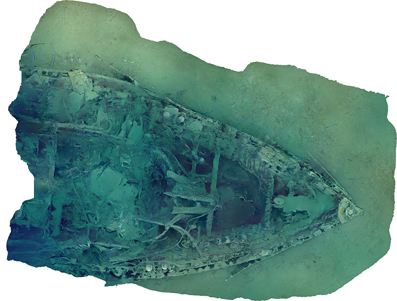
Orthophoto looking down (plan view) on the wreck of the tugboat New Hope. Image courtesy of the Bureau of Ocean Energy Management, Gulf of Mexico 2018. Download largest version (jpg, 1.7 MB).
How does it work?
Photogrammetry consists of collecting images using either a remotely operated vehicle (ROV) or a team of divers. A camera moves over the site in a pre-planned route, taking hundreds or thousands of still shots from the top, sides, and inside of the structure. It is important for the photos to overlap so that every inch of the site is recorded at more than one distance and angle. Video footage can also be used for photogrammetry by creating still images through video capture.
What happens next?
Once the divers or ROV have finished collecting imagery, the photos are merged into one large file and corrected for color balance and exposure. Next, the images are processed through photogrammetry software. The program uses an algorithm to create a photo mosaic, which retains the detail of each individual image, and then searches for common landmarks within the photos such as a ship hull fragment. Each landmark is oriented on the landscape using data about its size, surface area, and spatial position; all of this information creates what is called a data point cloud. This point cloud is used to map nodes or vertices onto a solid surface, resulting in a 3D model of the site. At this point, the model is completely colorless, so the software uses color data from the original images in order to “paint” in the pixel of every feature.

The steps of producing a basic photogrammetric model. From left to right is the initial alignment of images and point cloud generation. Next is the dense point cloud, followed by blank mesh interpolated from the dense points. The textured mesh uses the pixel values from the original images to assign color values across the surface of the solid mesh. Image courtesy of Thunder Bay National Marine Sanctuary/NOAA. Download largest version (jpg, 4.2 MB).
Why is it important?
Models created with photogrammetry are an important part of digital preservation. Over time, an archaeological site or a seafloor feature can be physically altered by factors like the natural process of deterioration, salinity, the pH of the water, erosion from sand, ocean currents, and human disturbance. A 3D model acts as a highly detailed snapshot in time and lets scientists explore a site without worrying about deterioration or physically disturbing the site. These models can also reveal characteristics of a site that may have been missed on an initial visit, and can help with planning future excavations. Additionally, NOAA and partners use photogrammetry to make maritime heritage sites accessible to the public .
Photogrammetry is also important for the study of biology and marine life. Scientists have recently started using this process to document coral reefs. In the past, two-dimensional documentation was used to assess the health of coral, but 3D models can give new insights into a reef’s biodiversity, nutrient recycling, and how ocean events may affect its health.

A photogrammetric model of the tugboat New Hope, which sank in 1965 during Tropical Storm Debbie. The model was developed by Bureau of Ocean Energy Management (BOEM) Marine Archaeologist Scott Sorset and features the bow section of the shipwreck. Image courtesy of the Bureau of Ocean Energy Management, Gulf of Mexico 2018. Download largest version (jpg, 590 KB).
This text was adapted from a 2017 Thunder Bay National Marine Sanctuary expedition log.