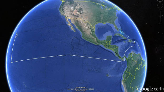
Proposed track lines for the ship during this expedition. Leg I is in the Caribbean Sea between San Juan, Puerto Rico, and Panama City, Panama. Leg II is in the eastern Pacific Ocean between Panama City, Panama, and Pearl Harbor, Hawaii, along the Clipperton Fracture Zone. Image courtesy of Google Earth. Download larger version (jpg, 158 KB).
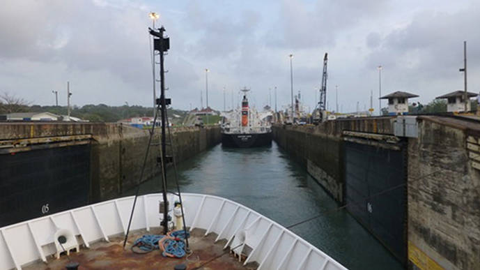
From May 8 to June 12, NOAA Ship Okeanos Explorer will journey from the Atlantic Ocean to the Pacific Ocean, exploring along the way. After her latest expedition in the Caribbean, Okeanos Explorer will leave port in San Juan, Puerto Rico, in order to traverse the Western Caribbean, Panama Canal, and Eastern Pacific. In addition to exploratory mapping, the ship will pursue several projects that contribute to NOAA’s mission and goals.
Okeanos Explorer will map the seafloor 24 hours a day for 33 days (except in foreign waters where permission has not been granted to do so), creating an approximately 7,000-nautical-mile-long (13,000 kilometer) swath bathymetry map of the seafloor. Several other datasets will be collected in addition to bathymetry, including seafloor backscatter, water column backscatter, split-beam sonar, and subbottom profiles. XBT casts will also be conducted at regular intervals.
The expedition provides a unique opportunity to map along the Clipperton Fracture Zone, which was identified as a priority feature to map during the 2014 Ocean Exploration Trust Eastern Pacific Planning Workshop. Extending across the eastern Pacific Rise for thousands of kilometers, this prominent bathymetric feature has never been mapped with a high-resolution multibeam system. By opportunistically mapping this feature, the Okeanos Explorer increases the possibility of discovering new seafloor features, such as gaseous seeps or manganese-nodule deposits. Furthermore, new bathymetric data of the feature may provide new insight into the complex geological history of the Pacific Plate.

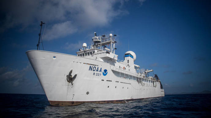
NOAA Ship Okeanos Explorer, the only federal vessel dedicated to ocean exploration, set sail on a 7,000-nautical-mile-long journey from the Caribbean to the Pacific on May 8. Image courtesy of NOAA Ocean Exploration and Research. Download image (jpg, 36 KB).
The Pacific Ocean contains a majority of the world’s seamounts, but large portions of this ocean, and many of its seamounts, remain largely unexplored by high-resolution sonar. During this expedition, over 8,500 square nautical miles (30,000 square kilometers) of the Pacific Ocean will be mapped with multibeam sonar.
In addition to mapping, several partner projects will leverage the ship’s track through remote parts of the Pacific to pursue ocean exploration and research goals. These include a survey of opportunity conducted on behalf of the NASA Maritime Aerosol Network where mission personnel will use a sun photometer to collect measurements of the marine aerosol layer. Three other projects will be conducted on behalf of NOAA’s Pacific Marine Environmental Lab on Leg II of the expedition, including the deployment of a dozen ARGO floats, which are part of a global ocean observation network; the recovery of two Pico-Prawler ocean observation moorings; and the deployment of an instrument called the seasnake, which will be used to measure surface salinity values. All of these projects will provide valuable oceanographic data to the scientific community; the Pico-Prawler moorings and the seasnake support climate change/climate modeling research.
Both legs of the expedition (San Juan–Panama City and Panama City–Pearl Harbor) will also be used to train new personnel in data collection and processing, including mapping watch leads and mapping interns, and to test new and modified hardware and software.