Kelley Elliott, Operations Lead - NOAA Office of Ocean Exploration and Research

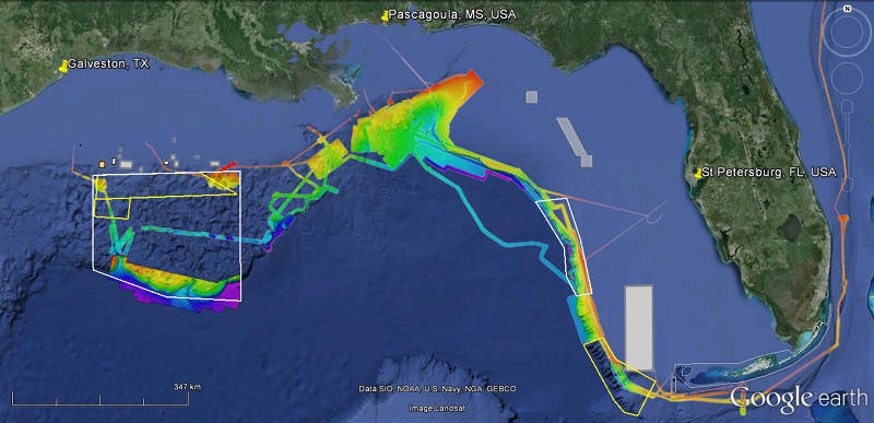
Expedition overview map showing bathymetry data acquired by NOAA Ship Okeanos Explorer from 2011-2012 and Law of the Sea Extended Continental Shelf Data on the Sigsbee Escarpment (courtesy UNH CCOM). Yellow boxes are priority mapping areas for cruise Legs 1 and 2. White boxes are priority areas for focused daytime ROV exploration and overnight mapping during cruise Leg 3. Image courtesy of the NOAA Office of Ocean Exploration and Research. Download larger version (jpg, 371 KB).

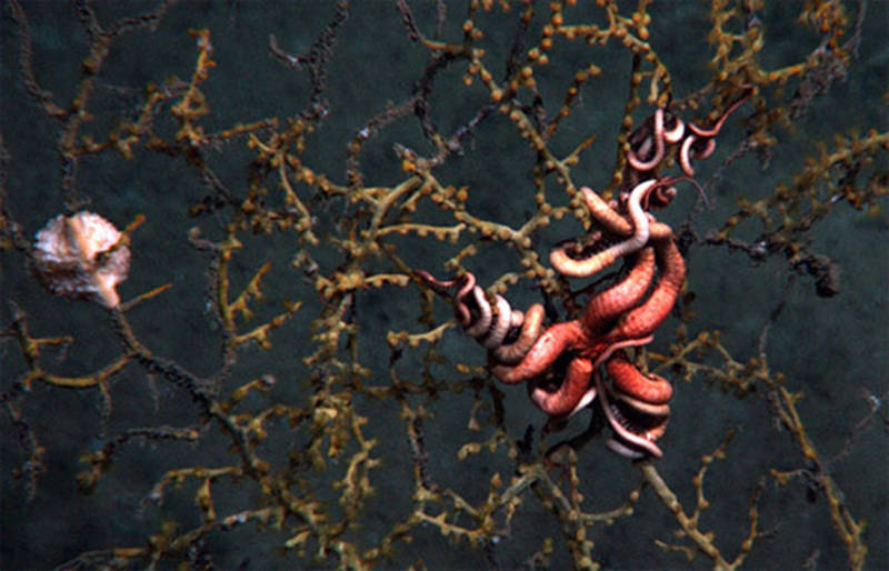
In 2010, cameras on the Jason ROV captured images of a seafloor site about seven miles downstream from a plume of hydrocarbons flowing from the Deepwater Horizon/Macondo well. Scientists found deep-sea corals showing signs of recent and severe impact. DWH clearly raised the need for more baseline data and information in the Gulf. Image courtesy of Lophelia II 2010 Expedition, NOAA-OER/BOEM. Download image (jpg, 76 KB).
“America’s Ship for Exploration,” NOAA Ship Okeanos Explorer is the nation’s first and only federal vessel with a mandate to explore our mostly unknown ocean for the purpose of discovery. Okeanos conducts community-driven systematic ocean exploration, working with the broader ocean science community to identify priority areas for exploration with a high potential for discovery. These areas are typically identified through community-driven workshops.
The first community-driven workshop to identify priority areas for exploration was held in 2007. Designed and organized by the Ocean Exploration Advisory Working Group, hosted by the National Geographic Society , and funded by the Richard Lounsbery Foundation , the ocean science community was invited to submit white papers identifying priority areas for exploration in the Pacific Ocean. White papers were received, and a workshop convened to discuss the submissions and identify priority areas for systematic ocean exploration. The results from this workshop, combined with input from other NOAA management groups, informed operating areas for Okeanos operations in the Pacific from 2008-2010.
By the end of 2011, Okeanos Explorer had sailed through the Panama Canal and arrived at her home port in North Kingstown, Rhode Island. In preparation for her arrival to the Atlantic Basin and the future arrival of the Ocean Exploration Trust’s E/V Nautilus (supported largely by OER), another community workshop was held at the University of Rhode Island to identify priority areas for exploration in the Atlantic Ocean Basin, including the Gulf of Mexico, that could be addressed using the capabilities of the two telepresence-enabled exploration vessels.
Since commencing Okeanos operations in 2008, the political climate in the U.S. had changed. The Deepwater Horizon (DWH) incident occurred in April 2010, spilling millions of gallons of crude oil into the Gulf of Mexico. Impacts on the ecosystem were tremendous, and the impacts on sensitive ecosystems in deep water were largely unknown, due in part to limited pre-spill information. Much of the public, non-industry data on deep-sea ecosystems in the Gulf of Mexico prior to DWH was conducted with support from OER and partners.
DWH clearly raised the need for more baseline data and information in the Gulf, and more generally in deep-water areas of the U.S. Exclusive Economic Zone (EEZ). In response, NOAA’s Okeanos ExplorerProgram conducted a mapping campaign from 2011-2013 acquiring baseline mapping data in key thematic areas identified during the 2011 Atlantic workshop in both the U.S. Gulf of Mexico and Atlantic Continental Shelf break.
Leveraging this mapping data, the Okeanos Explorer Program then took the next step in systematic exploration in each region. Working with the community to identify priority targets for investigation using a deep-water remotely operated vehicle (ROV), two telepresence-enabled ROV cruises were conducted in the Gulf of Mexico in March-April 2012 and addressed three of the priority exploration areas identified during the 2011 workshop.
During the summer of 2013, an expedition focused on the Northeast U.S. Canyons. U.S. submarine canyons were identified as a priority exploration theme during the 2011 Workshop and to further narrow which canyons to investigate, OER reached out to other NOAA programs, management agencies, and regional councils to identify priority canyon areas and targets for investigation. Both expeditions were successful and acquired critical environmental intelligence supporting current and future management needs.

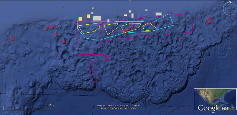
Interest in deepwater areas in the Northwest Gulf of Mexico was expressed by a range of organizations. Image courtesy of the NOAA Office of Ocean Exploration and Research. Download larger version (jpg, 368 KB).
Planning to return to the Gulf of Mexico in 2014 for continued targeted deepwater exploration in the U.S. EEZ, we modified our approach to cruise planning. Three of five exploration areas identified by the 2011 community workshop in the U.S. Gulf of Mexico were addressed during the 2012 Expedition. The Southwest Florida Escarpment and Florida Straits remained – two areas notoriously difficult for conducting ROV operations.
In order to identify priority exploration areas and data needs of highest priority to NOAA and the ocean science and management communities for the 2014 Field Season and beyond, the Okeanos Explorer Program reached out to NOAA Programs, Offices, and Labs and related management councils and revisited the results of the Atlantic Basin Workshop for input on priority areas for exploration that could be addressed with Okeanoscore capabilities.
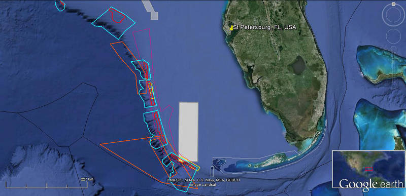
We received a tremendous amount of input! OER and OkeanosSenior Science and Program Advisors reviewed the input and identified operating areas for each cruise based on the aforementioned sources; gaps in contemporary, high-resolution mapping data; and areas identified by OER that will support future partnerships and operations. Several areas rose to the top as priority areas in need of further exploration for both mapping and ROV exploration – the west and southwest Florida escarpment and an area of the Northwest Gulf of Mexico (south and southeast of the Flower Garden Banks National Marine Sanctuary).

Interest in the West Florida Escarpment was expressed by a range of organizations. Image courtesy of the NOAA Office of Ocean Exploration and Research. Download larger version (jpg, 359 KB).
After NOAA and the fisheries management councils were polled to provide input on priority exploration areas or “boxes,” OER again reached out to the management community to identify specific targets for investigation with our deep-water ROV. Input was received from multiple NOAA programs, including Flower Garden Banks National Marine Sanctuary (FGBNMS), the National Centers for Coastal and Ocean Science (NCCOS), the National Systematics Laboratory, and OER; the Gulf of Mexico Fisheries Management Council (GMFMC); and federal agencies including the Bureau of Ocean Energy Management, Bureau of Safety and Environmental Enforcement, and U.S. Geological Survey.
Exploration targets ranged from historically significant shipwrecks to sensitive habitats including deep-sea corals and oil and gas seeps hosting communities of chemosynthetic life. Dives at all of these sites will help inform future management discussions and actions.
Leg 2 of this Expedition focused on acquiring high-resolution mapping data of deep water areas (500 meters and deeper) to support follow-on exploration activities and complement existing FGBNMS capabilities. NOAA’s FGBNMS Research Vessel (R/V) Manta is equipped with multibeam sonar optimized for acquiring data in relatively shallow water and can acquire mapping data to fill in gaps connecting Sanctuary-protected banks to deep water. Their mid-depth ROV Mohawk can also be outfitted and operated from aboard R/V Manta to conduct seafloor investigations down to 1,000 meters. With this in mind, Leg 3 ROV operations focused on investigating seafloor targets 1,000 meters and deeper.
Cruise Leg 1 conducted a focused mapping survey over a high-priority area of the southwest Florida escarpment to provide baseline mapping data and support future efforts. Cruise Leg 3 will leverage Okeanos-acquired mapping data from previous years to conduct ROV dives on priority sites identified by the management community on the central-west Florida Escarpment. These priority sites include dives at possible deep-sea coral sites near a small, golden crab fishery where past work has shown evidence of destructive fishing practices. The GMFMC is in the process of recommending areas for protection, and some of these dives will directly support their recommendations. Dives at all of these sites will help inform future management discussions and actions.
By working hand-in-hand with ocean managers and interested scientists to plan and execute exploration missions, NOAA’s Okeanos Explorer Program ensures that the data and information acquired meets the current and future needs of as many stakeholders as possible. The value of the data acquired during our exploration missions then becomes greater than the sum of the individual interests and parts: partnerships are forged and resources and intellectual capital leveraged to enable highly efficient and effective operations that provide baseline characterization to stimulate follow-on exploration, research, and management activities.