By Elizabeth “Meme” Lobecker, NOAA Ship Okeanos Explorer Physical Scientist/Mapping Team Lead
April 4, 2012

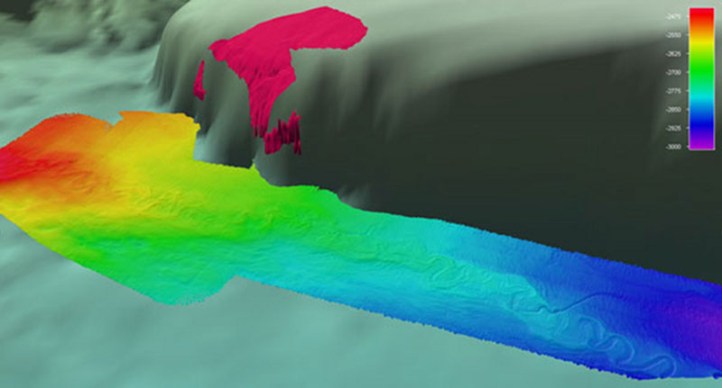
Fledermaus screenshot showing detail of multibeam coverage of the leveed meandering channel. Dashed white oval highlighting possible new channel branch. Additional background data shown courtesy of Sandwell and Smith2. Color scale bar showing depth in meters. Image courtesy of the NOAA Office of Ocean Exploration and Research, Gulf of Mexico Expedition 2012. Download larger version (jpg, 395 KB).
In the afternoon of March 27, when I laid out the lines to extend existing Okeanos Explorer multibeam coverage of the flat muddy bottom just west of the base of the West Florida Escarpment, I was not expecting the resulting data to generate very much excitement.

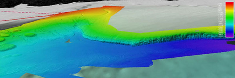
A Fledermaus screenshot showing overview of multibeam coverage surrounding leveed meandering channel. Dashed yellow oval highlighting extent of meandering channel as of 7 April 2012. The West Florida Escarpment is clearly shown in background EM 302 multibeam data. Additional background data shown courtesy of Sandwell and Smith. Color scale bar showing depth in meters. Image courtesy of the NOAA Office of Ocean Exploration and Research, Gulf of Mexico Expedition 2012. Download larger version (jpg, 325 KB).
At dinner time, with the remotely operated vehicle Little Hercules and camera platform Seirios securely fastened to the deck, the mapping department jumped to action, starting the sonar systems and conducting the evening’s first expendable bathythermograph (XBT). I stayed up late to examine the previous day’s data, going to bed around 0200 ship time.
When I woke up the next morning, the mapping watchstanders were excited: “We mapped a river!” Having not consumed any coffee since rising eight minutes prior, I didn’t have the foggiest idea what they were talking about; my mental pistons were most definitely not firing yet. I grabbed some high-octane coffee and viewed the gridded data first in our processing software, CARIS, and then our 3-D visualization software, Fledermaus.
Indeed, it appeared we had mapped a river, or rather a very long, very meandering feature on the seabed that looked very similar to a terrestrial river. Luckily, Dr. James Gardner, Dr. Larry Mayer, and Dr. Robert Carney were quick to share their expertise with the crew onboard to identify the feature we had mapped was a meandering leveed channel system.

A graphic from Wood and Mize-Spanzky showing measured features of a meandering channel including meander and channel characteristics. Image courtesy of the NOAA Office of Ocean Exploration and Research, Gulf of Mexico Expedition 2012. Download larger version (jpg, 119 KB).
The channel was impressive at first glance, having large, loopy meanders, well-defined channel walls, and sediment levees on either side. It has likely been created over time by turbidity currents flowing south, extending from the Mississippi River Fan. The channel is surrounded by a nearly perfectly flat bottom, and sits in about 2,400 to 2,700 meters of water, and is generally about 500 meters wide from channel wall to channel wall is sitting on a pile of sediments approximately 30 meters higher than the basin floor. The meanders are distinct and well formed. Shore based experts all quickly pointed out that there appears to be a new branch forming outward from the main channel.
The data were beautiful and mysterious, with a sinuous channel that looked well defined and continued off the edge of the EM 302 multibeam’s swath, leaving the mapping team eager to map it as far as it goes, or until it enters Cuban, and off-limits waters.
Is this a new feature to the science of the Gulf of Mexico? Unknown. Levee-channel systems have been found and studied in offshore areas around the world, including in the West Indies, the Gulf of Alaska, and even by the Okeanos Explorer near Mendocino Ridge off of northern California (pdf, 15.0 MB). Studies of these channels have varied, including focusing on sinuosity of meanders, and grain size and sorting at different points along the channel.
At the time of writing this log, no reference to the channel mapped by the Okeanos Explorer during this cruise was found in the scientific literature. There appears to be a single line of publically available multibeam data in the vicinity, collected in 1990 by the Maurice Ewing and its Atlas Hydrosweep DS multibeam system.
To date, over 144 kilometers of the length of the levee-channel system have been mapped by the Okeanos Explorer. The final leg of this cruise in the Gulf of Mexico will provide the mapping team the opportunity to continue mapping this interesting feature as we conduct exploration activities from Galveston, Texas, to Norfolk, Virginia. It is the hope of the team that these data will spur further scientific research, possibly including analysis of the geologic and sedimentary processes that lead to the particular characteristics of the levees, comparative studies of the slopes and sinuosity of the meanders, and if the potentially new branch is, in fact, new, and the implications of why it is forming at this particular time in geologic history.
All data collected by NOAA Ship Okeanos Explorer is made publically available via the national data archives within 90 days of the end of each cruise.
Wood, Lesli J., K. L. Mize-Spansky, 2009, Quantitative seismic geomorphology of a Quaternary leveed-channel system, offshore eastern Trinidad and Tobago, northeastern South America: The American Association of Petroleum Geologists Bulletin, v. 93, No. 1, pp. 101 – 125.
Smith, W. H. F., and D. T. Sandwell, Global seafloor topography from satellite altimetry and ship depth soundings, Science, v. 277, p. 1957-1962, 26 Sept., 1997.
The mapping department would like to thank the following for their shoreside support in analyzing the multibeam data: