By Robert S. Carney, Prof. Dept Oceanography and Coastal Sciences - Louisiana State University

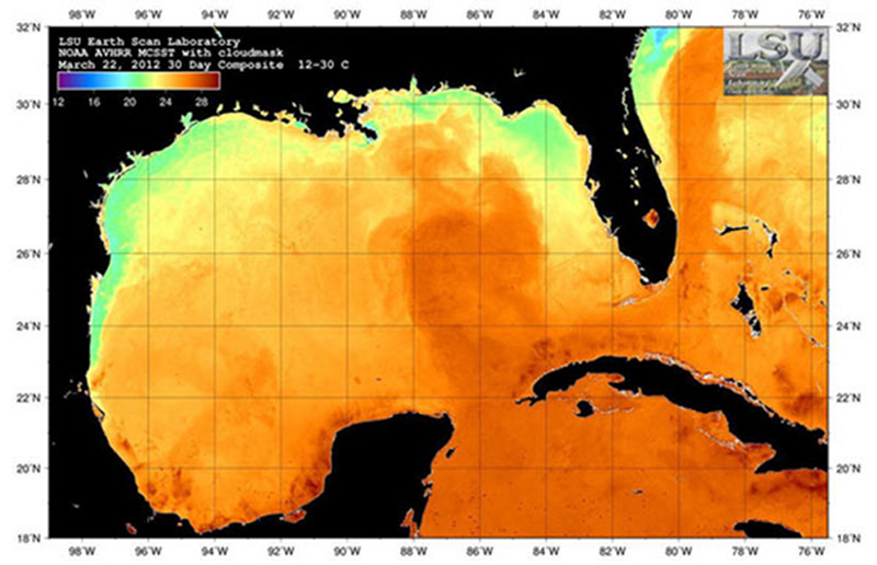
Currents also create hills and depressions in the ocean surface as they flow. Only a few tens of centimeters high over distances of hundreds of kilometers, these sea surface altitude changes can also be measured and mapped from space. Image courtesy of Louisiana State University. Download image (jpg, 84 KB).
There are many technical challenges to controlling seafloor exploration at 3,000 meters by the Seirios/Little Herc from the R/V Okeanos Explorer far above on the surface. Sometimes the challenges of surface and bottom conditions cannot be overcome and a particular location has to be considered to be undiveable.

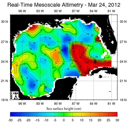
Gulf of Mexico sea-surface altitude indicating where water has been piled up by strong currents. Image courtesy of Louisiana State University. Download image (jpg, 86 KB).
The R/V Okeanos Explorer on the surface must hold a position and heading within narrow limits even as it is pushed by currents, winds, and waves. Deep below the remotely operated vehicle (ROV) is probably experiencing weaker currents, but possibly in a different direction than at the surface. And, the entire length of the cable is being pushed and pulled according to different currents at depth. At planned dive sites along the southern portion of the West Florida Escarpment (WFE), the dynamic positioning system cannot always beat all the forces of a unique current system, the Gulf of Mexico Loop Current.
The surface to bottom water of the WFE is a very tiny part of a global circulation system which is very different at the top of the ocean than at the bottom. Propelled by the uneven solar heating between poles and equator, the atmosphere and ocean are linked systems perpetually in motion. The surface water of ocean basins in the northern and southern hemispheres are driven in great rotating current systems called gyres.
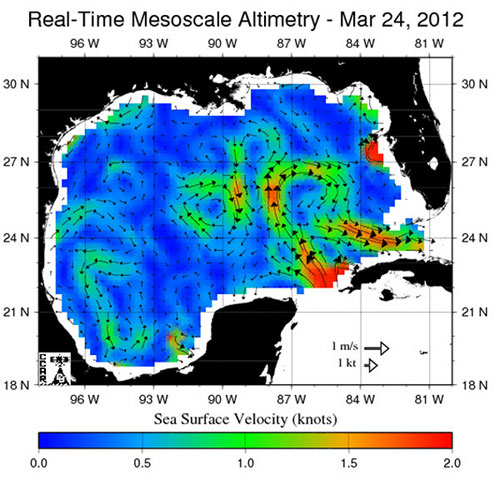
The WFE is washed by the Loop Current, an unusual part of the western edge of the North Atlantic Gyre. The Loop Current can be especially fast, especially deep, and especially unpredictable. It may flow as fast as 200 centimeters/second (3.89 knots) at the surface and still be flowing at 0.1 meters/sec (0.194 knots) at 1,000 meters. It can elongate and retract along its route from the Caribbean into the Atlantic with an irregular period of 6 to 20 months.

Gulf of Mexico Sea-surface altitude indicating surface current speed Image courtesy of Louisiana State University. Download image (jpg, 83 KB).
The western edge of all gyres is a region where the rotation of the Earth compresses and speeds up current flow. Although part of the whole gyre it has been a maritime tradition to name the local segments. The nature of 32 such local segments can be found at the Cooperative Institute for Marine and Atmospheric Studies . The Gulf Loop is the segment of the intensified western boundary current which flows into the Gulf of Mexico through the straits of Yucatan and exits through the Straits of Florida. Sometimes its path is confined to the coast of Cuba. At other times, it flows along a long loop to the North before turning south and eventually exiting through the Straits of Florida. This elongated loop is unstable and pinches off large eddies that spin clockwise as they drift westward. The eddies eventually spin down in the western Gulf. Because of the north-south extension and retraction, the WFE experiences different flow regimes which can make ROV deployment impossible some time. As the expedition moves north, it will escape the unfavorable impact of the Loop.
Deep currents have not been as well known as surface currents, but recent increases in current measurement technology are now providing much greater information. Geologists have long been aware that the deep Gulf has current-carved features associated with fast flow.
At the base of the Sigsbee Escarpment where we will be on Leg III, there are current-excavated deep and long furrows. Explorers in submersibles and ROVs have seldom experienced the strong currents which must exist periodically. It appears that deep circulation is linked to the energy from the Loop Current and its gyres. Bottom currents that may be periodically strong are to be expected where the ocean intersects with steep slopes like the West Florida and Sigsbee Escarpments.