
By Meme Lobecker, Expedition Coordinator, Physical Scientist, NOAA Office of Ocean Exploration and Research
Adam Skarke, Physical Scientist - NOAA Office of Ocean Exploration and Research
Frank Cantelas, Maritime Archaeology Program Officer - NOAA Office of Ocean Exploration and Research
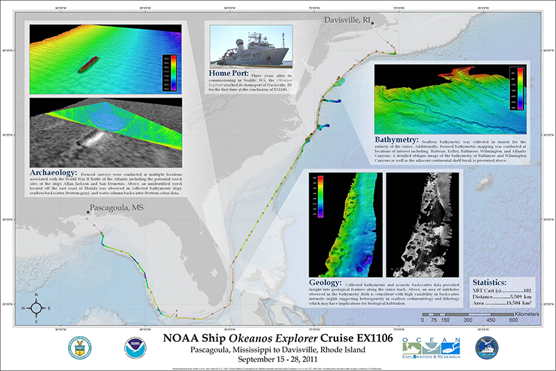
Overall Cruise Map created in ArcMap showing all EM 302 multibeam mapping data collected during EX1106. Image courtesy of the NOAA Office of Ocean Exploration and Research. Download larger version (jpg, 2.0 MB).
EX1106 was the final cruise of the 2011 field season for the NOAA Ship Okeanos Explorer. Prior to this cruise, the ship spent the year making her way from San Francisco, California, through the Panama Canal, across the Caribbean Sea, into the Gulf of Mexico, and finally up the U.S. east coast to its new permanent home port in Davisville, Rhode Island. In all, greater than 143,000 km sq of seafloor were mapped throughout the year, ranging from depths of less than 100 meters when coming into and out of ports of call, to over 6000 meters in the Cayman Trough.
With the mapping department fully staffed for 24-hour data collection, the EX commenced EX1106 on September 15th, departing Pascagoula, Mississippi for a strategically planned offshore route to Rhode Island. Our trackline brought us adjacent to the data collected during the previous cruise EX1105, where the mapping team worked with UNH scientists to successfully demonstrate the hull-mounted EM 302 multibeam sonar’s ability to detect and map gaseous seeps in the water column, notably near the Deep Water Horizon oil spill incident. The ship then continued a strategic transit along the Atlantic Shelf Break, again overlapping with data collected during the previous cruise, until rounding Florida to steam north and map through the shallow Florida Strait.
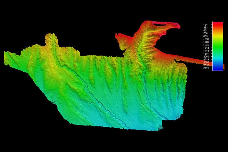
Plan view looking west, showing EM 302 multibeam bathymetry of South Wilmington (right) and Baltimore (left) Canyons. Image courtesy of the NOAA Office of Ocean Exploration and Research. Download larger version (jpg, 387 KB).
After mapping an as-yet unidentified possible WWII shipwreck off the southeast coast of Florida, we headed offshore to the Atlantic continental shelf break in order to map along an 800 kilometer long transect. The data collected will be used by the Department of the Interior’s Bureau of Offshore Energy Management (BOEM) when considering potential offshore energy development of the U.S Mid-Atlantic coast that may impact sensitive cultural and natural resources, and will compliment shallower adjacent data collected by the NOAA Ship Nancy Foster. Significant portions of six shelf-breaking canyons were mapped, including Pamlico, Keller, South Wilmington, Baltimore, Block, and Atlantis Canyons. A portion of Hatteras Channel was also mapped.
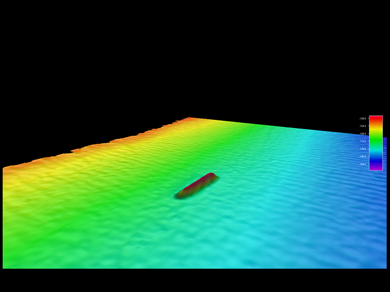
Image courtesy of the NOAA Office of Ocean Exploration and Research. Download larger version (jpg, 569 KB).
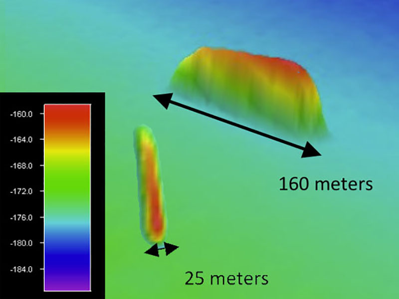
Image courtesy of the NOAA Office of Ocean Exploration and Research. Download image (jpg, 60 KB).
Two screen grabs showing EM 302 multibeam bathymetry data collected off the Florida east coast over the surveyed wreck area.
Three focused mapping surveys were conducted over underwater cultural heritage areas, again in partnership with BOEM and ONMS. One survey was conducted just south of Pamlico Canyon (see image below) in support of the Monitor National Marine Sanctuary’s (MNMS) multi-year study of the history and archaeology of the WWII Battle of the Atlantic (BOTA). The area was chosen based on GIS analysis conducted by ONMS. While naval actions between Axis and Allied powers occurred across the entire Atlantic basin from 1939 to 1945, a significant portion took place off the U.S. East Coast, including the area around Cape Hatteras, NC. In the U.S., most of the merchant ship losses to German U-boats occurred at the beginning of America’s involvement in the war, from January to July of 1942. There are 125 known losses from both sides during BOTA off North Carolina. During this period, Germany brought the war to the America, engaging in battle within sight of those ashore. The loss of merchant shipping impacted our ability to wage war. Collectively, the ships lying on the bottom are historically significant, representing a crisis period in American history.
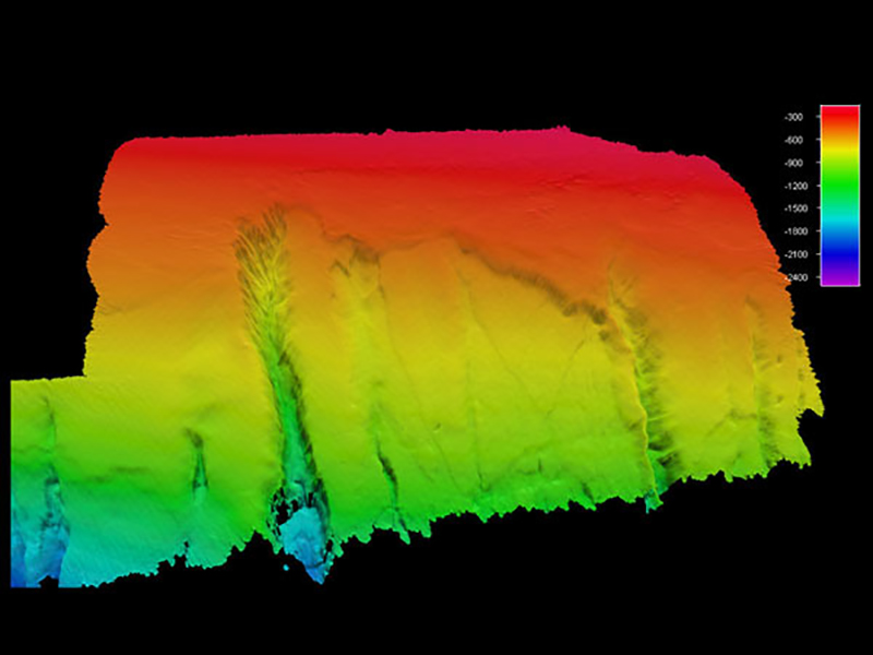
Bathymetry from the survey conducted just south of Pamlico Canyon. Image courtesy of the NOAA Office of Ocean Exploration and Research. Download image (jpg, 181 KB).
Two wreck investigations were conducted to search for WWII maritime casualties. The Allan Jackson (132.6 meters long x 17 meters abeam), one of the first victims of Allied Germany’s Operation Drumbeat, was lost on January 18, 1942, approximately 128 kilometers off Cape Hatteras, NC, in 2400 meters of water. The San Demetrio (146 meters long x 18.59 meters abeam) was lost on March 17, 1942, approximately 208 kilometers off the Virginia coast in 2700 meters of water. This wreck is a key subject of BOEM’s Mid-Atlantic Canyons study, and was also identified as an exploration target of interest during the 2011 Ocean Exploration Advisory Working Group’s Atlantic Basin Workshop. 200% coverage searches were conducted over the reported positions of the wrecks using the hull-mounted EM 302 multibeam. Although neither wreck was definitively located, each general location was determined to be uniform in sediment type and show an overall slope of less than 1°.
The exciting 2011 field season came to an end when the EX transited up Narragansett Bay, throwing the inaugural lines at its new berth at Quonset Development Corporation in Davisville, Rhode Island. She will spend the winter there getting a few upgrades to ship systems, including new mapping data processing computers!